File:Triangulation primordiale de la Suisse, 1838 (Swisstopo-000-450-765).tiff

Original file (4,488 × 2,703 pixels, file size: 34.73 MB, MIME type: image/tiff)
Captions
Captions
Summary
edit| Title |
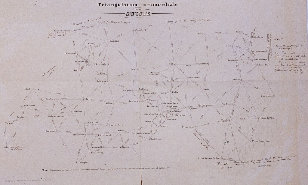
Français : Triangulation primordiale de la Suisse
Deutsch: Triangulationskarte der Schweiz von 1838 |
| Date | |
| Source | File:Swisstopo-000-450-765-Triangulationskarte der Schweiz von 1838.tiff |
| Geotemporal data | |
| Map location | Switzerland |
| Map type | trig point diagram |
| Scale | 1:625,000 |
| Georeferencing | If inappropriate please set warp_status = skip to hide. |
| Other versions |
|

.jpg)
.jpg)


| Triangulationskarte der Schweiz von 1838 | |||
|---|---|---|---|
| Photographer |
Mitarbeitende Bundesamt für Landestopografie swisstopo |
||
| Title |
Triangulationskarte der Schweiz von 1838 |
||
| Description |
Triangulation primordiale de la Suisse, 1838: Lithographie von Schweizer und Grimminger in Zürich, Massstab ca. 1:625 000. Diese mittels Triangulation erstellte Karte bildet die Vermessungsgrundlage für die Topographische Karte der Schweiz, auch Dufourkarte genannt. |
||
| Depicted place | Switzerland | ||
| Date | 2003 | ||
| Medium | Celluloseacetat farbig | ||
| Dimensions | 24 x 36 mm | ||
| Collection | Bundesamt für Landestopografie - Bildsammlung | ||
| Current location |
Bildsammlung swisstopo
|
||
| Accession number |
000-450-765 / TnA40228r |
||
| References | |||
| Source | Swisstopo | ||
Licensing
editThe data made publicly available by swisstopo may be used, distributed and made accessible. Furthermore, they may be enriched and processed and also used commercially. A reference to the source is mandatory. In the case of digital or analogue representations and publications, as well as in the case of dissemination, one of the following source references must be attached in any case:
Terms of use for free geodata and geoservices (OGD) from swisstopo
|
.svg) |
File history
Click on a date/time to view the file as it appeared at that time.
| Date/Time | Thumbnail | Dimensions | User | Comment | |
|---|---|---|---|---|---|
| current | 20:53, 12 October 2023 |  | 4,488 × 2,703 (34.73 MB) | Enhancing999 (talk | contribs) | File:Swisstopo-000-450-765-Triangulationskarte der Schweiz von 1838.tiff cropped 21 % horizontally, 50 % vertically using CropTool with precise mode. |
You cannot overwrite this file.
File usage on Commons
The following 2 pages use this file:
File usage on other wikis
The following other wikis use this file:
- Usage on de.wikipedia.org