File:UBBasel Map 1568 Kartenslg Schw Ca 1.tif

Size of this JPG preview of this TIF file: 800 × 353 pixels. Other resolutions: 320 × 141 pixels | 640 × 283 pixels | 1,024 × 452 pixels | 1,280 × 565 pixels | 2,560 × 1,130 pixels | 23,302 × 10,289 pixels.
Original file (23,302 × 10,289 pixels, file size: 1.32 GB, MIME type: image/tiff, 2 pages)
Captions
Captions
Add a one-line explanation of what this file represents
Summary edit
| Warning | The original file is very high-resolution. It might not load properly or could cause your browser to freeze when opened at full size. |
|---|
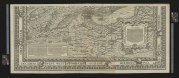
| Title |
Eigendtliche und grundtliche Verzeichnung aller Stetten, Graffschafften, Herrschafften, Landen, Gerichten und Gebieten so einer Statt Zürych zugehörig sind |
||||||||||||||||||||||||||
| Description |
Eigendtliche und grundtliche Verzeichnung aller Stetten, Graffschafften, Herrschafften, Landen, Gerichten und Gebieten so einer Statt Zürych zugehörig sind / dise Landtaffelen ist gerissen und in truck verfertiget durch Josen Murer |
||||||||||||||||||||||||||
| Date | |||||||||||||||||||||||||||
| Source | 10.3931/e-rara-12919 : Info: Kartenportal.CH | ||||||||||||||||||||||||||
| Creator |
|
||||||||||||||||||||||||||
| Permission (Reusing this file) |
|
||||||||||||||||||||||||||
| Geotemporal data | |||||||||||||||||||||||||||
| Scale | Ca. 1:56 000 | ||||||||||||||||||||||||||
| Bounding box |
|
||||||||||||||||||||||||||
| Georeferencing | If inappropriate please set warp_status = skip to hide. | ||||||||||||||||||||||||||
| Bibliographic data | |||||||||||||||||||||||||||
| Language | ger | ||||||||||||||||||||||||||
| Printed by |
Zu Zürych, by Christoffel Froschower |
||||||||||||||||||||||||||
| Archival data | |||||||||||||||||||||||||||
| Collection |
|
||||||||||||||||||||||||||
| Accession number |
Basel UB, Kartenslg Schw Ca 1 |
||||||||||||||||||||||||||
| Dimensions | 105 × 125 cm (41.3 × 49.2 in) | ||||||||||||||||||||||||||
| Medium | Holzschnitt | ||||||||||||||||||||||||||
| Notes | Titelkartusche oben links; weitere Kartuschen oben rechts, sowie rechts und links unten | ||||||||||||||||||||||||||


File history
Click on a date/time to view the file as it appeared at that time.
| Date/Time | Thumbnail | Dimensions | User | Comment | |
|---|---|---|---|---|---|
| current | 01:30, 12 September 2015 |  | 23,302 × 10,289, 2 pages (1.32 GB) | Basel University Library (talk | contribs) | =={{int:filedesc}}== {{Map | accession number = Basel UB, [http://aleph.unibas.ch/F/?local_base=DSV01&con_lng=GER&func=find-b&find_code=SYS&request=002633073 Kartenslg Schw Ca 1] | author = Jos Murer | date = 1568 | demo = | description = Eigendtli |
You cannot overwrite this file.
File usage on Commons
The following 2 pages use this file: