File:UBBasel Map 1582 Kartenslg Schw A 66 Helvetia.tiff

Size of this JPG preview of this TIF file: 747 × 600 pixels. Other resolutions: 299 × 240 pixels | 598 × 480 pixels | 957 × 768 pixels | 1,275 × 1,024 pixels | 2,551 × 2,048 pixels | 13,560 × 10,888 pixels.

Original file (13,560 × 10,888 pixels, file size: 422.43 MB, MIME type: image/tiff, 2 pages)
Captions
Captions
Add a one-line explanation of what this file represents
Summary edit
| Warning | The original file is very high-resolution. It might not load properly or could cause your browser to freeze when opened at full size. |
|---|
| Title |
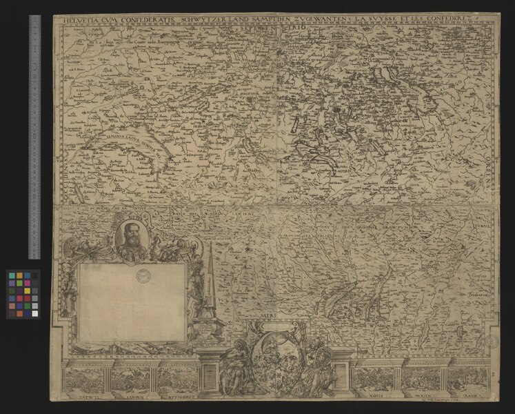
Helvetia cum Confederatis |
|||||||||||||||||||||||
| Description |
Helvetia cum Confederatis = Schwytzerland sampt den Zugewanten = Suysse et les confederez / Christoff Murer Tiguri |
|||||||||||||||||||||||
| Date | ||||||||||||||||||||||||
| Source | 10.3931/e-rara-12947 : Info: Kartenportal.CH | |||||||||||||||||||||||
| Creator |
Christoph Murer (1558-1614) |
|||||||||||||||||||||||
| Permission (Reusing this file) |
|
|||||||||||||||||||||||
| Geotemporal data | ||||||||||||||||||||||||
| Scale | Ca. 1:500 000 | |||||||||||||||||||||||
| Bounding box |
|
|||||||||||||||||||||||
| Georeferencing | If inappropriate please set warp_status = skip to hide. | |||||||||||||||||||||||
| Bibliographic data | ||||||||||||||||||||||||
| Language | lat | |||||||||||||||||||||||
| Printed by |
Zürich?, s.n. |
|||||||||||||||||||||||
| Archival data | ||||||||||||||||||||||||
| Collection |
|
|||||||||||||||||||||||
| Accession number |
Basel UB, Kartenslg Schw A 66 |
|||||||||||||||||||||||
| Dimensions | height: 55 cm (21.6 in); width: 72 cm (28.3 in) | |||||||||||||||||||||||
| Medium | Kupferstich | |||||||||||||||||||||||
| Notes | Unten rechts: Kartusche mit Portrait von Wilhelm Tugginer Ritter; Ansonsten ist die Kartusche leer / Massstab in graph. Form ("Ein Schwyzer Mill.") / Unterhalb des Kartenbildes: Ansichten der Schlachten von: Tatwyl, Loupen, Butisholtz, Naefels, Murten, Granse / Beilage: Artikel in der NZZ vom 13. Dezember 1942: "Die Schweizerkarte des Christoph Murer von 1582" | |||||||||||||||||||||||


File history
Click on a date/time to view the file as it appeared at that time.
| Date/Time | Thumbnail | Dimensions | User | Comment | |
|---|---|---|---|---|---|
| current | 17:46, 18 August 2015 |  | 13,560 × 10,888, 2 pages (422.43 MB) | Basel University Library (talk | contribs) | GWToolset: Creating mediafile for Basel University Library. |
You cannot overwrite this file.
File usage on Commons
The following 2 pages use this file: