File:VFR Terminal Area Chart for San Diego, 6th Edition - DPLA - 80b07c1ba6ca1575d4ecd741cc3b6151 (page 2).pdf

Size of this JPG preview of this PDF file: 800 × 457 pixels. Other resolutions: 320 × 183 pixels | 640 × 366 pixels | 1,024 × 585 pixels | 1,575 × 900 pixels.
Original file (1,575 × 900 pixels, file size: 3.37 MB, MIME type: application/pdf)
Captions
Captions
Add a one-line explanation of what this file represents
Summary
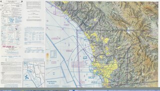
edit| VFR Terminal Area Chart for San Diego, 6th Edition
( |
||||||||||||||
|---|---|---|---|---|---|---|---|---|---|---|---|---|---|---|
| Creator | Department of Commerce. National Oceanic and Atmospheric Administration. National Ocean Service. (1983) | |||||||||||||
| Title |
VFR Terminal Area Chart for San Diego, 6th Edition |
|||||||||||||
| Date | May 1983 | |||||||||||||
| Collection |
|
|||||||||||||
| Source/Photographer |
|
|||||||||||||
| Permission (Reusing this file) |
|
|||||||||||||
| Standardized rights statement |
|
|||||||||||||


File history
Click on a date/time to view the file as it appeared at that time.
| Date/Time | Thumbnail | Dimensions | User | Comment | |
|---|---|---|---|---|---|
| current | 20:16, 9 November 2022 |  | 1,575 × 900 (3.37 MB) | DPLA bot (talk | contribs) | Uploading DPLA ID 80b07c1ba6ca1575d4ecd741cc3b6151 |
You cannot overwrite this file.
File usage on Commons
The following page uses this file: