File:Vienna basin.png

Size of this preview: 696 × 600 pixels. Other resolutions: 279 × 240 pixels | 557 × 480 pixels | 892 × 768 pixels | 1,189 × 1,024 pixels | 2,194 × 1,890 pixels.
Original file (2,194 × 1,890 pixels, file size: 2.1 MB, MIME type: image/png)
Captions
Captions
Add a one-line explanation of what this file represents
Summary
edit
| Description |
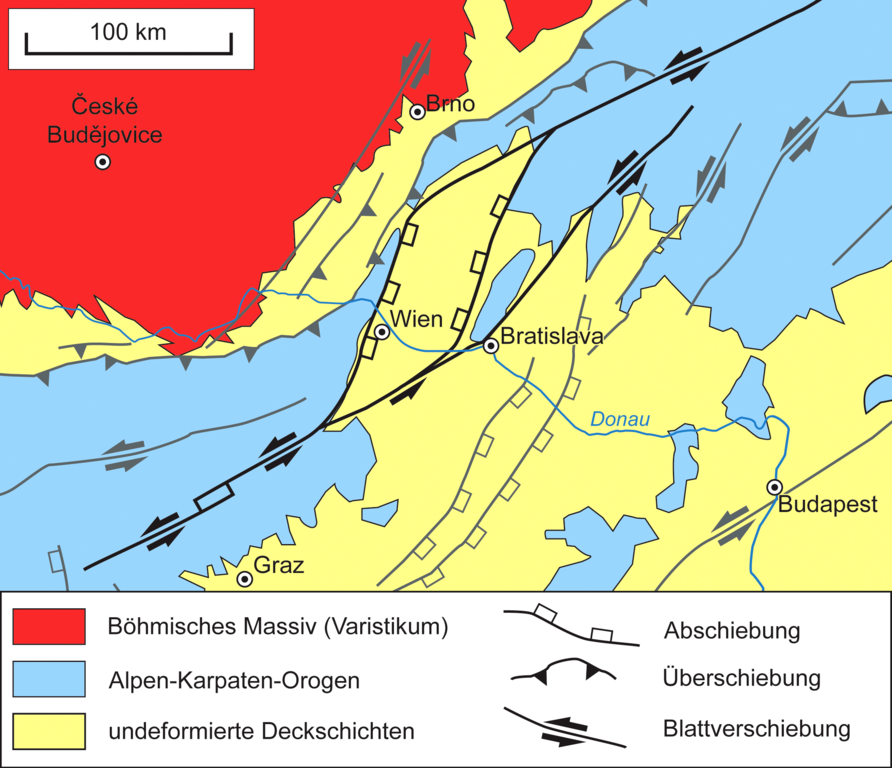
English: Simplified geological map of Vienna Basin and adjacent areas. The tectonic features immediately related to the Vienna Basin are shown in black; all other tectonic features are shown in grey. Redrawn from map (Abb. 3) in Piller et al. (1996)[1]
Deutsch: Vereinfachte geologische Karte des Wiener Beckens und Umgebung. Die Strukturen, die unmittelbar mit dem Wiener Becken in Zusammenhang stehen, sind schwarz eingezeichnet; alle übrigen Strukturen sind grau dargestellt. Nach Karte (Abb. 3) in Piller et al. (1996)[1] |
| Date | |
| Source | Own work |
| Author | Gretarsson |
References
edit
- ↑ a b Werner E. Piller, Kurt Decker, Margit Haas: Sedimentologie und Beckendynamik des Wiener Beckens. Field Guide SEDIMENT '96 (11th Meeting of Sedimentologists, Vienna, 1996), online (PDF, 6.0 MB)
Licensing
edit
I, the copyright holder of this work, hereby publish it under the following licenses:

|
Permission is granted to copy, distribute and/or modify this document under the terms of the GNU Free Documentation License, Version 1.2 or any later version published by the Free Software Foundation; with no Invariant Sections, no Front-Cover Texts, and no Back-Cover Texts. A copy of the license is included in the section entitled GNU Free Documentation License. |
This file is licensed under the Creative Commons Attribution-Share Alike 3.0 Unported, 2.5 Generic, 2.0 Generic and 1.0 Generic license.
- You are free:
- to share – to copy, distribute and transmit the work
- to remix – to adapt the work
- Under the following conditions:
- attribution – You must give appropriate credit, provide a link to the license, and indicate if changes were made. You may do so in any reasonable manner, but not in any way that suggests the licensor endorses you or your use.
- share alike – If you remix, transform, or build upon the material, you must distribute your contributions under the same or compatible license as the original.
You may select the license of your choice.
File history
Click on a date/time to view the file as it appeared at that time.
| Date/Time | Thumbnail | Dimensions | User | Comment | |
|---|---|---|---|---|---|
| current | 23:39, 13 February 2013 | | 2,194 × 1,890 (2.1 MB) | Gretarsson (talk | contribs) | {{Information |Description ={{en|1=Simplified geological map of Vienna Basin and adjacent areas}} {{de|1=Vereinfachte geologische Karte des Wiener Beckens und Umgebung}} |Source ={{own}} |Author =Gretarsson |Date ... |
You cannot overwrite this file.
File usage on Commons
The following page uses this file:
File usage on other wikis
The following other wikis use this file:
- Usage on de.wikipedia.org
- Usage on ro.wikipedia.org