File:View looking s.e., showing Keating channel at left -a.jpg

Size of this preview: 800 × 172 pixels. Other resolutions: 320 × 69 pixels | 1,920 × 413 pixels.
Original file (1,920 × 413 pixels, file size: 247 KB, MIME type: image/jpeg)
Captions
Captions
Add a one-line explanation of what this file represents
| Description |
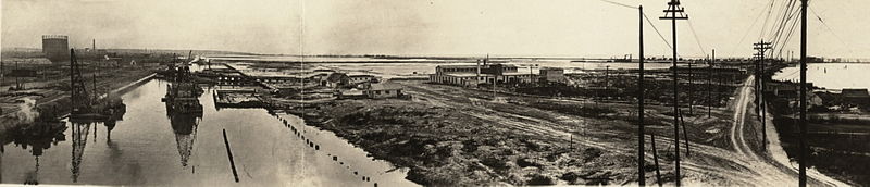
A panorama of the Keating Channel, the infill of Ashbridges Bay, and a dirt track roughly where the southmost portion of Cherry Street will be laid. This photo was probably taken by someone who climbed the bridge over the Keating Channel, while it was in its raised position.
|
|||
| Date | ||||
| Source | http://www.torontopubliclibrary.ca/detail.jsp?Entt=RDMDC-PICTURES-R-1397&R=DC-PICTURES-R-1397 Courtesy of Toronto Public Library | |||
| Author | Unknown author | |||
| Permission (Reusing this file) |
|


File history
Click on a date/time to view the file as it appeared at that time.
| Date/Time | Thumbnail | Dimensions | User | Comment | |
|---|---|---|---|---|---|
| current | 03:53, 20 January 2013 | 1,920 × 413 (247 KB) | Geo Swan (talk | contribs) | {{Information |Description=View looking s.e., showing Keating channel at left *{{original caption|Cf. Toronto Board of Harbour Commissioners annual report, 1921-22, p.9. Inscribed in the photograph l.l.: 1914. TEC 690Ab}} |Source=http://www.torontopub... |
You cannot overwrite this file.
File usage on Commons
The following page uses this file: