File:Voivodship and Serbia.png

Size of this preview: 457 × 599 pixels. Other resolutions: 183 × 240 pixels | 366 × 480 pixels | 724 × 949 pixels.
Original file (724 × 949 pixels, file size: 75 KB, MIME type: image/png)
File information
Structured data
Captions
Captions
Add a one-line explanation of what this file represents
The factual accuracy of this map or the file name is disputed.
Reason: Please see the relevant discussion on the talk page. |  |
| DescriptionVoivodship and Serbia.png |
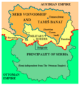
English: Political situation in 1849-1860: Serb Voivodeship and Banat of Temeschwar (Voivodeship of Serbia and Banat of Temeschwar) within Austrian Empire and Principality of Serbia within Ottoman empire.
Српски / srpski: Politička situacija 1849-1860. godine: Vojvodstvo Srbija i Tamiški Banat u okviru Austrijskog carstva i Kneževina Srbija u okviru Otomanskog carstva. |
|||
| Date | (UTC) | |||
| Source | ||||
| Author |
|
|||
| Permission (Reusing this file) |
|
|||
| Other versions |
|
Original upload log edit
This image is a derivative work of the following images:
- File:Serbia02.png licensed with PD-user
- 2009-06-01T18:50:11Z PANONIAN 717x944 (74592 Bytes)
- 2008-02-13T22:19:56Z Imbris 522x557 (28980 Bytes) The image must be free of POV. The image I'am proposing is using different colours for the Principality of Serbia and Serb Voivodship and Tamiš Banate.
- 2007-05-01T11:58:09Z Tene 522x613 (71735 Bytes) Optimised (0)
- 2006-12-21T21:40:49Z Electionworld 522x613 (88596 Bytes) {{ew|en|PANONIAN}} Self-made map by [[user:PANONIAN|PANONIAN]] {{PD-user|PANONIAN}} [[Category:Maps of Serbia]]
Uploaded with derivativeFX
File history
Click on a date/time to view the file as it appeared at that time.
| Date/Time | Thumbnail | Dimensions | User | Comment | |
|---|---|---|---|---|---|
| current | 15:18, 8 October 2013 |  | 724 × 949 (75 KB) | PANONIAN (talk | contribs) | aesthetics, uploader is free to revert if he does not agree with this change |
| 11:19, 5 December 2010 |  | 717 × 944 (74 KB) | 123iti (talk | contribs) | Reverted to version as of 11:13, 24 December 2009 This version looks better and more accurate | |
| 06:42, 19 January 2010 |  | 522 × 557 (28 KB) | Bidgee (talk | contribs) | Per Commons:Administrators' noticeboard/User problems#User:PANONIAN, Do not upload over other editors work. | |
| 11:13, 24 December 2009 |  | 717 × 944 (74 KB) | PANONIAN (talk | contribs) | aesthetics | |
| 10:46, 21 November 2009 |  | 717 × 944 (74 KB) | PANONIAN (talk | contribs) | this is proposed compromise version, please do not revert without discussion | |
| 18:49, 20 November 2009 |  | 522 × 557 (28 KB) | Tm (talk | contribs) | Reverted to version as of 17:30, 20 November 2009 (corrected atribution source to file version) | |
| 18:31, 20 November 2009 |  | 717 × 944 (72 KB) | PANONIAN (talk | contribs) | Reverted to version as of 10:45, 20 November 2009 this is map in serbian language, english versiom already exist, so please stop with your disruprive edits | |
| 17:30, 20 November 2009 |  | 522 × 557 (28 KB) | Mladifilozof (talk | contribs) | older version. please, do not replace this file without discussion. | |
| 10:45, 20 November 2009 |  | 717 × 944 (72 KB) | PANONIAN (talk | contribs) | new version - translated into Serbian with Latin script, since English language version already exist | |
| 08:09, 20 November 2009 |  | 717 × 944 (73 KB) | PANONIAN (talk | contribs) | this user uploaded an outdated version of map originally created by me, so I now would upload improved version of this map |
You cannot overwrite this file.
File usage on Commons
There are no pages that use this file.
File usage on other wikis
The following other wikis use this file:
- Usage on en.wikipedia.org

