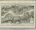
File:Wörth (Donauinsel) Joseph Walcher 1791 map.jpg

Size of this preview: 800 × 560 pixels. Other resolutions: 320 × 224 pixels | 640 × 448 pixels | 1,024 × 716 pixels | 1,280 × 895 pixels | 1,927 × 1,348 pixels.
Original file (1,927 × 1,348 pixels, file size: 737 KB, MIME type: image/jpeg)
File information
Structured data
Captions
Captions
Add a one-line explanation of what this file represents
Summary edit
| DescriptionWörth (Donauinsel) Joseph Walcher 1791 map.jpg |
Deutsch: Karte der Donauinsel Wörth, mit Hausstein, Strudel, Wirbel und Umgebung |
|||||||||||||||||||||||
| Date | ||||||||||||||||||||||||
| Source |
Aus der Monographie: Joseph Walcher: Nachrichten von den bis auf das Jahr 1791 an dem Donau-Strudel zur Sicherheit der Schiffahrt fortgesetzten Arbeiten nebst Anhang von der physikalischen Beschaffenheit des Donau-Wirbels. Wien, Kurzbeck 1791, Anhang. http://digital.slub-dresden.de/werkansicht/dlf/26676/47/ |
|||||||||||||||||||||||
| Author |
creator QS:P170,Q15821835 |
|||||||||||||||||||||||
| Other versions |
|
|||||||||||||||||||||||
| Object location | 48° 13′ 50″ N, 14° 53′ 13″ E | View this and other nearby images on: OpenStreetMap |
|---|
Licensing edit
| Public domainPublic domainfalsefalse |
|
This work is in the public domain in its country of origin and other countries and areas where the copyright term is the author's life plus 100 years or fewer. | |
| This file has been identified as being free of known restrictions under copyright law, including all related and neighboring rights. | |
https://creativecommons.org/publicdomain/mark/1.0/PDMCreative Commons Public Domain Mark 1.0falsefalse
File history
Click on a date/time to view the file as it appeared at that time.
| Date/Time | Thumbnail | Dimensions | User | Comment | |
|---|---|---|---|---|---|
| current | 11:19, 12 August 2015 |  | 1,927 × 1,348 (737 KB) | Thgoiter (talk | contribs) | Cropped 4 % horizontally and 21 % vertically using CropTool with lossless mode. |
| 06:44, 11 August 2015 |  | 2,000 × 1,697 (809 KB) | Ratzer (talk | contribs) | Reverted to version as of 06:38, 11 August 2015: map shows more, contrast can be improved | |
| 06:42, 11 August 2015 |  | 1,021 × 732 (340 KB) | Ratzer (talk | contribs) | Ausschnitt, Kontrastumfang | |
| 06:38, 11 August 2015 |  | 2,000 × 1,697 (809 KB) | Ratzer (talk | contribs) | {{Information |Description ={{de|1=Karte der Donauinsel Wörth, mit Hausstein, Strudel, Wirbel und Umgebung}} |Source =http://digital.slub-dresden.de/werkansicht/dlf/26676/47/ |Author =Joseph Walcher |Date =1791 |Permission... |
You cannot overwrite this file.
File usage on Commons
There are no pages that use this file.
File usage on other wikis
The following other wikis use this file:
- Usage on de.wikipedia.org

