File:Wacht am Rein Map HE.svg

Size of this PNG preview of this SVG file: 371 × 599 pixels. Other resolutions: 148 × 240 pixels | 297 × 480 pixels | 475 × 768 pixels | 634 × 1,024 pixels | 1,267 × 2,048 pixels | 557 × 900 pixels.
Original file (SVG file, nominally 557 × 900 pixels, file size: 660 KB)
Captions
Captions
Add a one-line explanation of what this file represents
Summary edit
| Description |
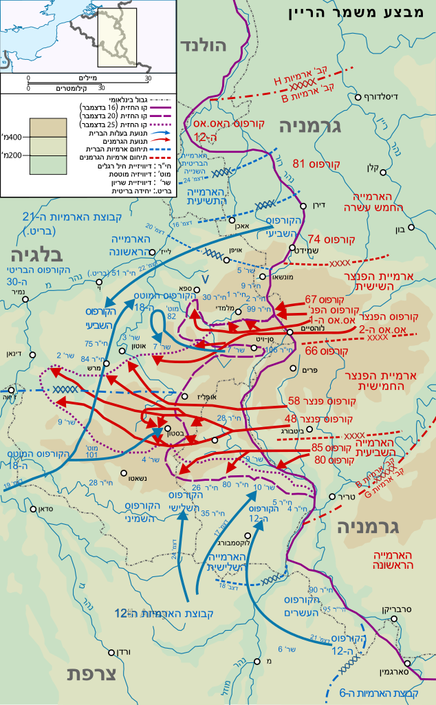
English: Map of the opening of the salient, the start of the Battle of the Bulge עברית: מפת מבצע משמר הריין, קרב הבליטה 25-16 בדמצבר 1944. |
| Date | (UTC) |
| Source |
This file was derived from: Wacht am Rhein map (Opaque).svg: .svg) |
| Author |
|
| This is a retouched picture, which means that it has been digitally altered from its original version. Modifications: hebrew. The original can be viewed here: Wacht am Rhein map (Opaque).svg:
|
Licensing edit
I, the copyright holder of this work, hereby publish it under the following license:
This file is licensed under the Creative Commons Attribution-Share Alike 3.0 Unported license.
- You are free:
- to share – to copy, distribute and transmit the work
- to remix – to adapt the work
- Under the following conditions:
- attribution – You must give appropriate credit, provide a link to the license, and indicate if changes were made. You may do so in any reasonable manner, but not in any way that suggests the licensor endorses you or your use.
- share alike – If you remix, transform, or build upon the material, you must distribute your contributions under the same or compatible license as the original.
Original upload log edit
This image is a derivative work of the following images:
- File:Wacht_am_Rhein_map_(Opaque).svg licensed with Cc-by-sa-3.0
- 2012-03-07T02:55:11Z Matthewedwards 557x900 (222071 Bytes) better
- 2012-03-07T02:46:01Z Matthewedwards 557x900 (215231 Bytes) Fixed line spacing on "NINTH ARMY", "FIRST ARMY", "FIFTEENTH ARMY", etc
- 2012-03-06T23:25:49Z Grandiose 557x900 (221286 Bytes) Remove stroke on lettering.
- 2012-03-06T01:51:23Z Matthewedwards 557x900 (222640 Bytes) Smoothed arrows, adjusted colour of Allied arrows
- 2012-03-04T12:20:54Z Grandiose 557x900 (221310 Bytes) Adjust key to new/oldest arrow style.
- 2012-03-04T12:13:40Z Grandiose 557x900 (220982 Bytes) Tweak frontlines in the Monschau-Malmedy-Prum area, demonstrating a German advance, per, for example, http://www.defense.gov/home/Specials/bulge/images/indexb_10a.jpg.
- 2012-02-14T06:09:51Z Matthewedwards 557x900 (220527 Bytes)
Uploaded with derivativeFX
File history
Click on a date/time to view the file as it appeared at that time.
| Date/Time | Thumbnail | Dimensions | User | Comment | |
|---|---|---|---|---|---|
| current | 05:38, 23 June 2015 | | 557 × 900 (660 KB) | קרלוס הגדול (talk | contribs) | . |
| 05:34, 23 June 2015 |  | 557 × 900 (630 KB) | קרלוס הגדול (talk | contribs) | Reverted to version as of 13:11, 26 April 2012 | |
| 20:15, 22 June 2015 |  | 557 × 900 (719 KB) | קרלוס הגדול (talk | contribs) | . | |
| 20:02, 22 June 2015 |  | 557 × 900 (630 KB) | קרלוס הגדול (talk | contribs) | Reverted to version as of 13:11, 26 April 2012 | |
| 17:47, 22 June 2015 |  | 557 × 900 (660 KB) | קרלוס הגדול (talk | contribs) | . | |
| 17:41, 22 June 2015 |  | 557 × 900 (630 KB) | קרלוס הגדול (talk | contribs) | Reverted to version as of 13:11, 26 April 2012 | |
| 20:32, 21 June 2015 |  | 557 × 900 (661 KB) | קרלוס הגדול (talk | contribs) | . | |
| 13:11, 26 April 2012 |  | 557 × 900 (630 KB) | InfidelHE (talk | contribs) | == {{int:filedesc}} == {{Information |Description={{en| Map of the opening of the salient, the start of the Battle of the Bulge }} {{he|1=מפת מבצע משמר הריין, קרב הבליטה 25-16 בדמצבר 1944.}} |Source={{Derived from|Wacht_a... |
You cannot overwrite this file.
File usage on Commons
The following page uses this file:
File usage on other wikis
The following other wikis use this file:
- Usage on he.wikipedia.org