File:War of the Pacific LOC map-fr.png

Size of this preview: 392 × 599 pixels. Other resolutions: 157 × 240 pixels | 314 × 480 pixels | 503 × 768 pixels | 670 × 1,024 pixels | 1,648 × 2,517 pixels.
Original file (1,648 × 2,517 pixels, file size: 274 KB, MIME type: image/png)
Captions
Captions
Add a one-line explanation of what this file represents
Translation of Image:War_of_the_Pacific_LOC_map.png by --Kimdime69 23:41, 1 January 2007 (UTC)
Summary edit
| Description |
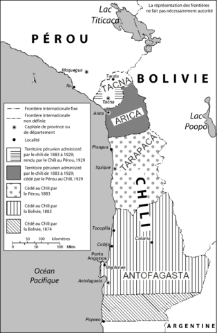
English: Map showing changes of territory due to the War of the Pacific
Español: Mapa que muestra cambios de territorio debido a la Guerra del Pacífico |
| Date | |
| Source | United States Library of Congress Country Studies. This is used as an illustration in the country studies on both Peru and Chile. |
| Author | United States Fedreal Government |
| Permission (Reusing this file) |
Public domain |
Licensing edit
This work is in the public domain in the United States because it is a work prepared by an officer or employee of the United States Government as part of that person’s official duties under the terms of Title 17, Chapter 1, Section 105 of the US Code.
Note: This only applies to original works of the Federal Government and not to the work of any individual U.S. state, territory, commonwealth, county, municipality, or any other subdivision. This template also does not apply to postage stamp designs published by the United States Postal Service since 1978. (See § 313.6(C)(1) of Compendium of U.S. Copyright Office Practices). It also does not apply to certain US coins; see The US Mint Terms of Use.
|
 | |
| This file has been identified as being free of known restrictions under copyright law, including all related and neighboring rights. | ||
File history
Click on a date/time to view the file as it appeared at that time.
| Date/Time | Thumbnail | Dimensions | User | Comment | |
|---|---|---|---|---|---|
| current | 16:12, 27 May 2017 | | 1,648 × 2,517 (274 KB) | Janitoalevic (talk | contribs) | Fixed Tacna borders, Tarata name and location |
| 23:39, 1 January 2007 |  | 1,648 × 2,517 (275 KB) | Kimdime (talk | contribs) | Translation of Image:War_of_the_Pacific_LOC_map.png |
You cannot overwrite this file.
File usage on Commons
The following page uses this file:
File usage on other wikis
The following other wikis use this file:
- Usage on ca.wikipedia.org
- Usage on fr.wikipedia.org
- Usage on ru.wikipedia.org