File:Washoe Lake, Nevada (21384150108).jpg

Original file (4,000 × 3,000 pixels, file size: 3.23 MB, MIME type: image/jpeg)
Captions
Captions
Summary
edit.jpg&action=edit§ion=1)
| Description |
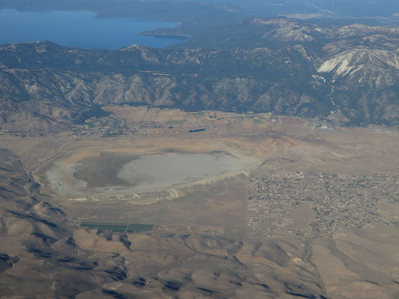
Washoe Lake is a lake located in the Washoe Valley of Washoe County, Nevada. It is between Reno and Carson City (nearer to Carson City). It is a very shallow lake, and the surface area can vary greatly from year to year. Washoe Lake is fed by several small streams which issue from the Carson Range to the west as well as ephemeral streams which flow from the Virginia Range to the east. At its northern end, Washoe Lake narrows and connects to Little Washoe Lake, at whose northernmost end issues Steamboat Creek. From the Carson Range, Washoe Lake receives (from south to north) Franktown Creek, Ophir Creek, Davis Creek and Winters Creek. Steamboat Creek receives Browns and Galena Creeks in Pleasant Valley, Nevada, and then runs north to meet the Truckee River on the eastern outskirts of Reno, Nevada. Much of the water from the Steamboat Creek/Washoe Lake Watershed is diverted for irrigation use. Washoe Lake is known for its high wind speeds. Mark Twain wrote: "A Washoe wind is by no means a trifling matter. It blows flimsy houses down, lifts shingle roofs occasionally, rolls up tin ones like sheet music, now and then blows a stage-coach over and spills the passengers; and tradition says the reason there are so many bald people there is, that the wind blows the hair off their heads while they are looking skyward after their hats." The same high wind speeds have remained to this day and are capable of overturning commercial vehicles traveling along Interstate 580/U.S. Highway 395, which runs along the western shore of Washoe Lake. en.wikipedia.org/wiki/Washoe_Lake en.wikipedia.org/wiki/Wikipedia:Text_of_Creative_Commons_... |
| Date | |
| Source | Washoe Lake, Nevada |
| Author | Ken Lund from Reno, Nevada, USA |
| Camera location | | View this and other nearby images on: OpenStreetMap |
|---|
.jpg¶ms=039.276130_N_-119.649637_E_globe:Earth_type:camera_source:Flickr_&language=en)
Licensing
edit.jpg&action=edit§ion=2)
- You are free:
- to share – to copy, distribute and transmit the work
- to remix – to adapt the work
- Under the following conditions:
- attribution – You must give appropriate credit, provide a link to the license, and indicate if changes were made. You may do so in any reasonable manner, but not in any way that suggests the licensor endorses you or your use.
- share alike – If you remix, transform, or build upon the material, you must distribute your contributions under the same or compatible license as the original.
| This image was originally posted to Flickr by Ken Lund at https://flickr.com/photos/75683070@N00/21384150108. It was reviewed on 4 December 2015 by FlickreviewR and was confirmed to be licensed under the terms of the cc-by-sa-2.0. |
File history
Click on a date/time to view the file as it appeared at that time.
| Date/Time | Thumbnail | Dimensions | User | Comment | |
|---|---|---|---|---|---|
| current | 04:43, 4 December 2015 | | 4,000 × 3,000 (3.23 MB) | INeverCry (talk | contribs) | Transferred from Flickr via Flickr2Commons |
You cannot overwrite this file.
File usage on Commons
There are no pages that use this file.
.jpg&oldid=930469815)