File:Wels - Ledererturm.JPG

Size of this preview: 399 × 599 pixels. Other resolutions: 160 × 240 pixels | 320 × 480 pixels | 512 × 768 pixels | 682 × 1,024 pixels | 1,365 × 2,048 pixels | 2,755 × 4,134 pixels.
Original file (2,755 × 4,134 pixels, file size: 8.98 MB, MIME type: image/jpeg)
Captions
Captions
Add a one-line explanation of what this file represents
Summary
edit| Description |
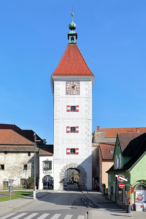
Deutsch: Westansicht des Ledererturmes in der oberösterreichischen Stadt Wels und links der sogenannte Schalenturm.
Der Ledererturm ist das Wahrzeichen der Stadt. Er blieb als einziger der vier Stadttürme erhalten, die im 13. Jahrhundert beim Bau der mittelalterlichen Stadtbefestigung errichtet wurden. Der urkundlich erstmals am 24. Juli 1326 erwähnte Turm wurde 1610 beim Angriff des „Passauer Kriegsvolkes“ schwer beschädigt und in der heutigen Form in den Jahren von 1616 bis 1619 durch den Maurermeister Marx Martin Spaz aus Linz wiederinstandgesetzt und umgebaut. Der fast 38 m hohe Turm hatte ursprünglich einen Zwiebelhelm, der jedoch beim Stadtbrand 1771 zerstört und durch ein Zeltdach ersetzt wurde. |
| Date | |
| Source | Own work |
| Author | C.Stadler/Bwag |
| Permission (Reusing this file) |
Deutsch: Hallo, du darfst mein Foto kostenlos nutzen, aber nenne mich bitte als Fotograf, beispielsweise „Foto: C.Stadler/Bwag“ oder © C.Stadler/Bwag; CC-BY-SA-4.0. Auf mehr Angaben bestehe ich nicht - im Gegensatz zu manch anderen, die die Vorgaben der unten angeführten Lizenzierung auf Punkt und Beistrich einfordern. English: Feel free to use my photos, but please mention me as the author like © C.Stadler/Bwag or © C.Stadler/Bwag; CC-BY-SA-4.0 (that's good enough) and if you want send me a message: bwag@gmx.net. |
| Other versions |
|
.JPG)
| Camera location | | View this and other nearby images on: OpenStreetMap |
|---|
Licensing
edit
I, the copyright holder of this work, hereby publish it under the following license:
This file is licensed under the Creative Commons Attribution-Share Alike 4.0 International license.
- You are free:
- to share – to copy, distribute and transmit the work
- to remix – to adapt the work
- Under the following conditions:
- attribution – You must give appropriate credit, provide a link to the license, and indicate if changes were made. You may do so in any reasonable manner, but not in any way that suggests the licensor endorses you or your use.
- share alike – If you remix, transform, or build upon the material, you must distribute your contributions under the same or compatible license as the original.
File history
Click on a date/time to view the file as it appeared at that time.
| Date/Time | Thumbnail | Dimensions | User | Comment | |
|---|---|---|---|---|---|
| current | 10:51, 2 November 2016 | | 2,755 × 4,134 (8.98 MB) | Bwag (talk | contribs) | c |
| 10:38, 2 November 2016 |  | 4,011 × 4,280 (15.08 MB) | Bwag (talk | contribs) | r | |
| 09:38, 2 November 2016 |  | 4,036 × 4,251 (15.17 MB) | Bwag (talk | contribs) | {{Information |Description= {{de|1= Westansicht des Ledererturmes in der oberösterreichischen Stadt Wels und links der sogenannte Schalenturm.<br/>Der Ledererturm ist das Wahrzeichen der Stadt. Er blieb als ei... |
You cannot overwrite this file.
File usage on Commons
The following page uses this file:
File usage on other wikis
The following other wikis use this file:
- Usage on be.wikipedia.org
- Usage on de.wikipedia.org
- Usage on de.wikivoyage.org
- Usage on en.wikipedia.org
- Usage on et.wikipedia.org
- Usage on hu.wikipedia.org
- Usage on la.wikipedia.org
- Usage on lld.wikipedia.org
- Usage on mn.wikipedia.org
- Usage on sv.wikipedia.org
- Usage on yi.wikipedia.org
- Usage on zh.wikipedia.org