File:Wien - Floridsdorfer Brücke.JPG

Size of this preview: 800 × 478 pixels. Other resolutions: 320 × 191 pixels | 640 × 382 pixels | 1,024 × 611 pixels | 1,280 × 764 pixels | 2,560 × 1,529 pixels | 4,724 × 2,821 pixels.
Original file (4,724 × 2,821 pixels, file size: 9.77 MB, MIME type: image/jpeg)
Captions
Captions
Add a one-line explanation of what this file represents
Summary
edit
| Description |
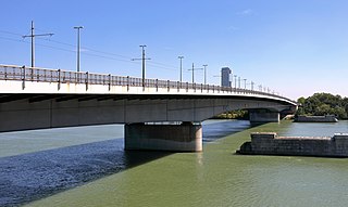
Deutsch: Die Floridsdorfer Brücke vom rechten Donauufer und flussaufwärts gesehen im 20. Wiener Gemeindebezirk Brigittenau. Rechts im Bild noch die zwei Brückenpfeiler der Vorgängerbrücke und im Hintergrund der Florido Tower. Die erste Floridsdorfer Brücke wurde 1872 errichtet und als Kaiser-Franz-Joseph-Brücke bezeichnet. Ab 1913 erfolgte die Errichtung einer neuen Brücke (als Umbau bezeichnet) und am 25. Juni 1924 als Floridsdorfer Brücke eröffnet. Ab April 1977 wurde stromaufwärts und knapp neben der alten Brücke die jetzige Brücke gebaut und am 3. Oktober 1978 eröffnet. Die Brücke gliedert sich in vier Teile: Die Kaibrücke, sie ist ca. 95 Meter lang, überbrückt den Handelskai sowie die Donauuferbahn und ist als Spannbetontragwerk mit Hohlkästen ausgeführt, die Strombrücke mit einem Stahltragwerk mit 332,5 Meter Länge, die Flutbrücke (über die Neue Donau), ebenfalls mit einem Stahltragwerk mit 215 Meter Länge, und die Kreuzungsplatte über der Donauuferautobahn A22. |
| Date | |
| Source | Own work |
| Author | C.Stadler/Bwag |
| Permission (Reusing this file) |
Deutsch: Hallo, du darfst mein Foto kostenlos nutzen, aber nenne mich bitte als Fotograf, beispielsweise „Foto: C.Stadler/Bwag“ oder © C.Stadler/Bwag; CC-BY-SA-4.0. Auf mehr Angaben bestehe ich nicht - im Gegensatz zu manch anderen, die die Vorgaben der unten angeführten Lizenzierung auf Punkt und Beistrich einfordern. English: Feel free to use my photos, but please mention me as the author like © C.Stadler/Bwag or © C.Stadler/Bwag; CC-BY-SA-4.0 (that's good enough) and if you want send me a message: bwag@gmx.net. |
| Object location | | View this and other nearby images on: OpenStreetMap |
|---|
| Camera location | | View this and other nearby images on: OpenStreetMap |
|---|
Licensing
edit
I, the copyright holder of this work, hereby publish it under the following license:
This file is licensed under the Creative Commons Attribution-Share Alike 4.0 International license.
- You are free:
- to share – to copy, distribute and transmit the work
- to remix – to adapt the work
- Under the following conditions:
- attribution – You must give appropriate credit, provide a link to the license, and indicate if changes were made. You may do so in any reasonable manner, but not in any way that suggests the licensor endorses you or your use.
- share alike – If you remix, transform, or build upon the material, you must distribute your contributions under the same or compatible license as the original.
File history
Click on a date/time to view the file as it appeared at that time.
| Date/Time | Thumbnail | Dimensions | User | Comment | |
|---|---|---|---|---|---|
| current | 17:29, 13 December 2019 | | 4,724 × 2,821 (9.77 MB) | Bwag (talk | contribs) | {{Information |Description= {{de|1= Die Floridsdorfer Brücke vom rechten Donauufer und flussaufwärts gesehen im 20. Wiener Gemeindebezirk Brigittenau. Rechts im Bild noch die zwei Brückenpfeiler der Vorgängerbrücke und im Hintergrund der Florido Tower<br/>Die erste Floridsdorfer Brücke wurde 1872 errichtet und als Kaiser-Franz-Joseph-Brücke bezeichnet. Ab 1913 erfolgte die Errichtung einer neuen Brücke (als U... |
You cannot overwrite this file.
File usage on Commons
The following page uses this file:
File usage on other wikis
The following other wikis use this file:
- Usage on de.wikipedia.org
- Usage on en.wikipedia.org
- Usage on fr.wikipedia.org
- Usage on www.wikidata.org