File talk:Map AP dist all shaded.png
Latest comment: 5 years ago by Jeff G. in topic Update to Map
Update to Map edit
-
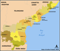 Map as per this file (outdated)
 -
 Andhra Pradesh Districts map with updated border


Should I overwrite the file with the new version? Is there any other alternative to replace in all the pages linking to this file by the new version.--Arjunaraoc (talk) 12:00, 3 April 2019 (UTC)
- I started Commons:Graphic Lab/Illustration workshop#Maps of districts of Andhra Pradesh to spur production of more scalable versions in svg format. — Jeff G. ツ please ping or talk to me 12:45, 4 April 2019 (UTC)