Hövelhof
municipality of Germany
Deutsch: Hövelhof ist eine Gemeinde in Nordrhein-Westfalen, Deutschland und gehört zum Kreis Paderborn.
Nederlands: Hövelhof is een plaats in de Duitse deelstaat Noord-Rijnland-Westfalen, gelegen in het district Paderborn.
municipality of Germany     | |||||
| Upload media | |||||
| Pronunciation audio | |||||
|---|---|---|---|---|---|
| Instance of |
| ||||
| Location |
| ||||
| Located in or next to body of water | |||||
| Head of government |
| ||||
| Population |
| ||||
| Area |
| ||||
| Elevation above sea level |
| ||||
| official website | |||||
 | |||||
Karten und Diagramme edit
English: maps and diagrammes
Lagekarten edit
-
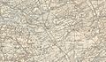
 Lage der Gemeinde Hövelhof im Kreis Paderborn
 -
 Lage der Gemeinde Hövelhof im Kreis Paderborn
 -
 Lage der Gemeinde Hövelhof im Kreis Paderborn
 -
 geothermische Karte


Alte Karten edit
-
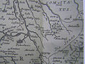
 1620
1620 -
 1672
1672 -
 1805
1805 -
 1843
1843 -
 1848
1848 -
 1909
1909
.jpg)

.jpg)


Hoheitszeichen edit
English: Insignia
Wappen edit
English: Coats of arms
-
 Gemeindewappen
Geschichte, Kultur und Sehenswürdigkeiten edit
English: history, culture and sites
Historische Gebäude edit
English: historical buildings
-
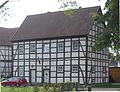
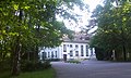
 ehemals fürstbischöfliches Jagdschloss,
heute Pastorei -
 Küsterhaus, ehemalige Schlossküche
 -
 Der Hövelhof (Wichmannhof), 1903 abgebrand


Kirchen und religiöse Gebäude edit
English: churches and religious buildings
-
 Ev. Johanneskirche
 -
 Kath. Kirche St. Johannes Nepomuk
 -
 Herz Jesu Kirche in Hövelriege
 -
 Herz Jesu Kirche in Espeln
 -
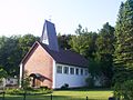
 Bredemeiers Kapelle


Kulturelle Gebäude edit
English: culture buildings
-
 Heimathaus Hövelhof

Wirtschaft und Infrastruktur edit
English: economy and infrastructure
Öffentliche Einrichtungen edit
English: Public utilities
-
 Rathaus
 -
 JVA Hövelhof, Pforte


Verkehr edit
English: traffic


Natur und Parks edit
English: nature and parks
Flüsse und Bäche edit
-
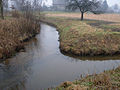
 Ems in der Moosheide
 -
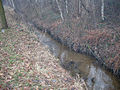
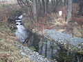
 Haustenbach bei Staumühle
 -
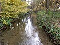 Furlbach bei Espeln
 -
 Krollbach in der Moosheide
 -
 Krollbach-Bifurkation
 -
 Mündung des Schwarzwasserbaches in die Ems
 -
 Holtebach
 -
 Hallerbach


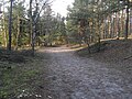
Moosheide edit
-
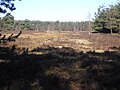 Heidefläche im März
 -
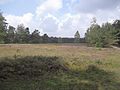 Heidefläche im August
 -
 Düne
Düne -
 Rosenlake – Quellgebiet des Hallerbachs
 -


Naturdenkmäler edit
-
 Friedenseiche
 -
 Findling am Ehrenmal
 -
 Franzosenstein


Gemälde und Zeichnungen edit
English: Paintings and Drawings
-
 „Niendorp“ in der Monumenta Paderbornensia
 -
 Das Emstal in der Monumenta Paderbornensia
 -
Der Hövelhof (Wichmannhof)


Postkarten edit
English: postcards
-
 1905: Gasthof Josef Nehler, Pastorat, Bahnhof
 -
 1910: Villa Wichmann, Pastorat (Schloss), Kirche, Gasthof Josef Nehler
 -
 1910: Staumühle


