Krafla (volcanic system)
Maps edit
-
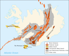 Volcanic systems of Iceland with Krafla in the North Volcanic Zone
 -
 The lake Mývatn with some volcanic features of Krafla


The central volcano: Krafla caldera edit
Krafla caldera edit
-

-
 The caldera in the background seen from the south


Víti crater edit
The Víti crater is a maar from the 18th century.


Leirhnjúkur edit
The volcano Leirhnjúkur was last active during the Krafla Fires in the 1970s and 1980s.
.jpg)
.jpg)

Hlíðarfjall edit
Hlíðarfjall is a hyaloclastic ridge near the western caldera rim.

Jörundur edit
Jörundur is a hyaloclastic ridge near the eastern caldera rim.


Around the lake Mývatn edit
Many volcanic features in connection with the Krafla volcanic system are to be found in and around the lake Mývatn.


Vindbelgjarfjall edit
Vindbelgjarfjall is a volcanic cone of subglacial origin.


Hverfjall edit
The volcano Hverfjall is a tuff ring.
.jpg)

Grjótagjá edit
The volcano-tectonic fissure Grjótagjá contains caves filled with hot water.
.jpg)
_by_DerHexer.jpg)
Jarðbaðshólar and the Mývatn Natural Bath edit
-
 Steaming crater row Jarðbaðshólar
 -
 Bathing facilities nearby

.jpg)
Námafjall and Hverarönd edit
The hyaloclastic ridge Námafjall and its high temperature area Hverarönd
-
 Hverarönd on the eastern side of Námafjall
 -
 The view to the west in direction of Mývatn


Geothermal power plants edit
Two geothermal power plants are situated within the Krafla volcanic system.
Bjarnarflag edit
The geothermal power plant of Bjarnarflag is situated not far from Mývatn and the village of Reykjahlíð.
-
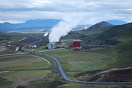
 Bjarnarflag Geothermal Power Plant
 -
 Bjarnarflag borehole
 -


Krafla Geothermal Power Plant edit
The Krafla Geothermal Power Plant is located directly to the south of the caldera rim.
-
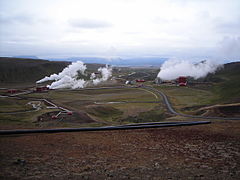
 Krafla Power Plant
 -
 Krafla Power Plant and some boreholes
.jpg)
