Maps and atlases from Koninklijke Bibliotheek


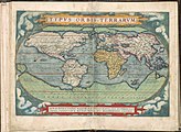
Atlas Ortelius 1571, collection KB edit
Theatrum Orbis Terrarum ("Theatre of the World") is considered to be the first true modern atlas. Written by Abraham Ortelius and originally printed on May 20, 1570, in Antwerp, it consisted of a collection of uniform map sheets and sustaining text bound to form a book for which copper printing plates were specifically engraved. The Ortelius atlas is sometimes referred to as the summary of sixteenth-century cartography.
-
 Voorplat
 -
 Titelpagina
 -
 001av-001br
 -
 002av-002br
 -
 003av-003br
 -
 004av-004br


Atlas De Wit 1698, collection KB edit
The Atlas De Wit (also: Town and city atlas De Wit) is unique, historic atlas by Dutch cartographer Frederick De Wit containing 158 city maps, city views and engravings from the northern and southern Netherlands (the current Netherlands, Belgium and French-Flanders).
-
 Voorplat
 -
 pl017 - Leiden
 -
 pl018a - Amsterdam, Dam
 -
 pl035-'s - Gravenhage
 -
 pl070 - Brussel
 -
 pl071 - Antwerpen


Admirandorum quadruplex spectaculum edit
Around 1700 Johannes van Call made some 70 drawings of Rhine landscapes and Dutch cities. The Amsterdam publisher and engraver Petrus Schenk loved these views and selected 71 to be published in a book: Admirandorum quadruplex spectaculum. The prints shown here are the result of an experiment of early multi-colour printing as invented by Jan Teyler of Nijmegen. With this so called à la poupée-technique, the printing plates are inked in different colours and then printed in multi-colours in one print run. See also: https://web.archive.org/web/20210627211328/https://www.kb.nl/themas/atlassen/viervoudig-schouwspel-van-wonderen (description in Dutch)
The atlas consists of 4 sets of prints:
- 19 prints of the Rhine river and the cities/villages bordering this river
- 19 prints of the palaces and houses of William III of England
- 10 prints of The Hague (Binnenhof surroundings)
- 17 prints of Amsterdam
-
 Titelpagina / Title page
 -
 18 - Bonn opwaarts trekkende naar het Zevengebergte / Bonn migrating upwards to the Seven Mountains
 -
 21 - Paleis Het Loo het koninklijk hof op het Loo, van voren / Paleis Het Loo the royal court on Het Loo, from the front
 -
 42 - Sorgvliet, gelegen aan de Scevelinger weg, het lusthuis van de Graaf van Portland / Sorgvliet, located on Scevelinger road, the pleasure house of the Earl of Portland
 -
 48 - Den Haag, het Binnenhof en galerij naar de Franse kerk / The Hague, the Binnenhof and gallery to the French church
 -
 62 - Amsterdam, Herengracht, ziende van de Spiegelstraat naar de Leidsche straat. / Amsterdam, Herengracht, looking from Spiegelstraat to Leidsche Straat


.jpg)
_(2).jpg)
_(2).jpg)
_(2).jpg)
Atlas van Dirk van der Hagen (volledig, collectie KB) edit
The Atlas Van der Hagen is a so-called composite atlas. This means that the term ‘atlas’ should not be interpreted in the modern sense of the word, as a ‘book of maps’, but taken in the wider sense: a collection of maps and topographical pictures, with additional portraits, pictures of animals and plants, mythological scenes, etc.
It is not exactly known who composed this atlas, but recent research regards the Amsterdam merchant and map collector Dirk van der Hagen as its compositor. Van der Hagen had brought together a considerable collection of drawings and prints and it seems that he choose the most beautiful ones to be colored by hand by the famous artist Dirk Jansz van Santen.
The atlas consists of four volumes bound in parchment:
- I. World map, North and East Europe
- II. United Kingdom, Netherlands, Belgium
- III. Spain, France, Italy, Greece
- IV. Asia, Africa, America, South Pole
These contain 446 maps and prints, in various formats, beautifully colored and decorated with gold: maps of Joan Blaeu and his father Willem Jansz Blaeu, Nicolaas Visscher II, Frederik de Wit and Jan Janssonius, and prints by Romeyn de Hooghe and others, all dating from the period up to 1689. This leads to the assumption that the atlas was composed around 1690. It has been held by the Koninklijke Bibliotheek since 1887, originating from the bequest of P.J.B.C. Robidé van der Aa.
-
 Volume 1 - 002 - NOVISSIMA TOTIUS TERRARUM ORBIS TABULA -Wereldkaart in 2 hemisferen
 -
 Volume 1 - 067 - NOBILISSIMI ALBIS FLUVII OSTIA, nec non HAMBURGENSE et alia Territoria adjacentia
 -
 Volume 2 - 055 - Novissima et accuratissima XVII PROVINCIARUM GERMANIAE INFERIORIS Delineatio
 -
 Volume 3 - 068 - Stadsprofiel van- VENETIA
 -
 Volume 4 - 056 - AFRICAE ACCURATA TABULA
 -
 Volume 4 - 100 - Kaart van de Zuidpool


Volume 1: Arctico Norwegia ... et Helvetiae - Atlas Van der Hagen (1) edit
-
 001 - Arctico Norwegio Succia Dania Russia Polonia Ukraniae Hung-a Germania et Helvetia
 -
 022 - Tabula exactissima Regnorum SUECIAE et NORVEGIAE nec non MARIS UNIVERSI ORIENTALIS, Terrarumq- adjacentium summo studio ab
 -
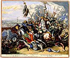 51 6A - Veroveren der groote Standaert en Nederlaeg der Turken = Prise du grand Estendart et defaicte entiere des Turcqs
 -
 073 - TYPVS FRISIAE ORIENTALIS.
 -
 085 - CAPTUM PHILIPSBURGUM A.o 1676 9-17
 -
 099 - ARGOW cum parte merid. ZVRICHGOW


Volume 2: Angliæ Scotiæ Hiberniæ et Germania Inferior sive XVII Provinciarum - Atlas Van der Hagen (2) edit
-
 002 - ACCURATISSIMA ANGLIAE SCOTIAE ET Hiberniae TAB. De ... in lucem edita à CAROLO ALLARD
 -
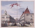
 015 - RECEPTIE VAN HARE K.H. M de PRINC. VAN ORANGIE. als koningin van gr- Britange = RECEPTION OF HER ROIAL HIGH. THE PRINCESSE OF ORANGE as queene of great Brittain
 -
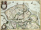 071 - t Meerderdeel van t OOST-VRYE in VLAENDEREN vertoonende doprechte gelegenh- der Landen, Fortressen, Schansen ende de nieuw bedijckte Polders
 -
 075 1 - LE PARC D ANGUIEN = HET PERK VAN ANGUIEN
 -
 083 - COMITATUS HOLLANDIAE TABULA PLURIBUS LOCIS RECENS EMENDATA A NICOLAO VISSCHER
 -
 091 - EXACTISSIMA AMSTELODAMI VETERIS ET NOVISSIMA DELINEATO PER F. DE WIT


Volume 3: Hispaniae, Galliae, Italiae et Graeciae - Atlas Van der Hagen (3) edit
-
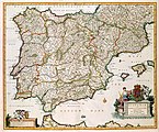 002 - HISPANIAE ET PORTUGALIAE REGNA
 -
 Vol 3 - 021 - LUTETIA PARISIORUM Vulgo PARIS
 -
 023 - Veue et perspective du Chateau et Jardin de Versailles, comme il est apresant
 -
 049 - TOTIUS ITALIAE TABULA
 -
 062 - Stadsprofiel van- GENOA
 -
 095 - PELOPON- NESVS sive MOREA


Volume 4: Asiae. Novus atlas sinensis a Martino Martinio descriptus ... - Atlas Van der Hagen (4) edit
-
 002 - ASIAE NOVA DELINEATIO
 -
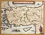 004 - NATOLIA, quae olim ASIA MINOR
 -
 026 - T WEESHUYS op BATAVIA
 -
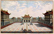 035 2 - Interior aulae Imperatoriae facies T KEYSERS HOF VAN BINNEN
 -
 072 - Novissima et Accuratissima TOTIUS AMERICAE DESCRIPTIO
 -
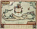 086 - Mappa AESIVARVM Insularum alias BARMVDAS dictarum, ad Ostia Mexicani aestuarij jacentium in latitudine Graduum 32 Minutorium 25 Ab Anglia


Atlas Schoemaker edit
The Atlas Schoemaker displays 2579 images of topographical drawings, descriptions and prints of Dutch towns, villages and hamlets in the early 18th century.
Andries Schoemaker (1660-1735) was an Amsterdam textile merchant whose passion was collecting historical and topographic information on towns and villages, and churches and castles in the Netherlands. In the 1720s, he visited almost all the towns, villages and hamlets in the Netherlands, often accompanied by his son Gerrit Schoemaker (1692-1736). He described the places he visited during these trips, including historical and cultural details.
Schoemaker often illustrated his descriptions by means of drawings, many in color, that he either made himself or had made by contemporary artists, such as Cornelis Pronk (1691-1759) and his apprentice Abraham de Haen II (1707-1748). At times he also made use of prints previously published to show the topographic situation in earlier periods. He either redrew these prints or he pasted them in his books. Occasionally he also made his own sketch maps or used existing maps in his work.
.jpeg)


Atlas of Mutual Heritage edit
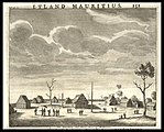
The Atlas of Mutual Heritage (AMH) contains more than 8.000 maps, drawings, prints and paintings of locations related to the Dutch East India Company (Verenigde Oost-Indische Compagnie, VOC) and the Dutch West India Company (West-Indische Compagnie, WIC). The vast majority of these images are in the public domain.
902 AMH images from the collection of the Koninklijke Bibliotheek have been uploaded to Commons
-
 Residence of the governor general within the walls of the castle at Batavia
 -
 Traitors in Jaffnapatnam being executed in 1658
 -
 View of the royal court at Tananarivo on Madagascar
 -
 View of the battle between the Dutch and the Portuguese for the city of San Salvador in the Bay of All Saints in 1624
 -
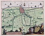 Map of Batavia and environs (1682)
 -
 Map of the northern part of India and the Himalayas


