DrRandomFactor
Dr. Random Factor, Ph.D - Vector Graphics, Election Maps, Legislature Diagrams, & Political Logos
A lifelong political enthusiast & amateur cartographer, I am a frequent uploader of election maps and other maps. My first election maps were for Canadian provinces and they were less than impressive. Since then I have expanded my skills and now consider myself a skilled cartographer. The program I use for making all of my maps is Adobe Illustrator. Data for the election maps is often sourced from news sources and Wikipedia.
My very good buddy/business partner is Mr.Election, and we frequently work together on election maps. Several of the following maps are co-authored between me and Mr.Election. I highly suggest giving his page a view as well, he makes many amazing election maps and he's even won a Wikimedia award!
I do take requests for election maps. If you would like to request an election map from me, send me a message on Wikimedia and I will get back to you as soon as I can. Or you can message me on Wikimedia. Whatever works best. Email is preferable however and I will provide my email address if asked. There is an FAQ section at the bottom of this page.
Below is a gallery of maps, legislature diagrams, and political logos I have created. Maps me and Mr.Election have co-authored are denoted with a Red Flag ("🚩") below.
Awards
edit
|
The Original Barnstar |
| Amazing job on all of these maps, your work is appreciated! Tyanc13and7 talk 23:25, 27 September 2017 (UTC) |

|
The Graphic Designer's Barnstar |
| Your maps are the best. Good job! Yilku1 (talk) 15:27, 31 October 2017 (UTC) |

|
The Brilliant Idea Barnstar |
| Mr.Election just informed me that you were the one who composed the map for the 2016 state house elections in Michigan. I am blown away by the detail; the map shows not just which party one each district, but the relative voter intensity. VERY good job! I'd love to see you do a few more for a few additional recent elections in the state since 2010 including the gubernatorial races by county and maybe post-redistricting (which would start in 2012) state legislative races. Criticalthinker (talk) 01:18, 4 December 2017 (UTC) |

|
The Surreal Barnstar |
| I think your election maps are some of the best on Wikimedia Commons! MB298 (talk) 03:59, 14 December 2017 (UTC) |
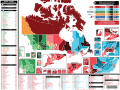
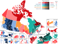
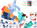
Canada & Canadian Provincial Maps
editMaps of Canada
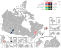
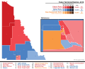
editCanadian Federal Election 2019 Maps
edit-
 Canadian federal election 2015 - Winning party vote by riding (PNG ONLY)

Canadian Federal Election 2015 Maps
edit-
 Canadian federal election 2015 - Winning party vote by riding (PNG ONLY)
 -
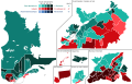
 Canadian federal election 2015 - Winning party vote by riding
 -
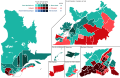
 Canadian federal election 2015 - Winning party colour map
 -
 By-Elections to the Canadian 42nd Canadian Parliament (2015-2019) (🚩co-authored by Mr.Election)
 -
 Blank Map of Canada's 338 ridings, as used in the 2015 federal election


.svg)


Canadian Federal Election 2015 - Party Vote Strength Maps
edit-
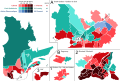
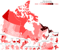 Canadian federal election 2015 - Liberal Party Vote Strength By Riding (🚩co-authored by Mr.Election)
 -
 Canadian federal election 2015 - Conservative Party Vote Strength By Riding
 -
 Canadian federal election 2015 - New Democratic Party Vote Strength By Riding (🚩co-authored by Mr.Election)
 -
 Canadian federal election 2015 - Bloc Quebecois Vote Strength By Riding (🚩co-authored by Mr.Election)
 -
 Canadian federal election 2015 - Green Party Vote Strength By Riding (🚩co-authored by Mr.Election)


Canadian Federal Election 2011 Maps
edit-
 Canadian federal election 2011 - Winning party vote by riding
 -
 Canadian federal election 2011 - Winning party colour map

.svg)
Previous Canadian Federal Election Maps
edit-
 Canadian federal election 1867 - Winning party vote by riding
 -
 Canadian federal election 1993 - Winning party vote by riding
 -
 Canadian federal election 2004 - Winning party vote by riding (🚩co-authored by Mr.Election)
 -
 Canadian federal election 2006 - Winning party vote by riding (🚩co-authored by Mr.Election)
 -
 Canadian federal election 2008 - Winning party vote by riding


Conservative Party Leadership Election 2017 Maps
edit-
 Canadian Conservative Party Leadership Election 2017 - First Round Vote By Riding
 -
 Canadian Conservative Party Leadership Election 2017 - 13th (Final) Round Vote By Riding ('🚩'co-authored by Mr.Election)
.svg)
.svg)
Canadian Senate Maps
edit-
 Senate of Canada - Seats by Province

Canadian Member of Parliament (MP) Voting Maps
edit-
 Bill C-45 (Cannabis Act) Nov. 27, 2017 - Final Reading Voting Results By Member of Parliament (MP)
 -
 Bill C-45 (Cannabis Act) Nov. 27, 2017 - Final Reading Voting Results By Member of Parliament (MP) (Simple Colours)
_-_Voting_Results_by_MP.svg)
_-_Voting_Results_by_MP_(Simple_Map).svg)
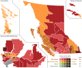
Maps of British Columbia
editBritish Columbia Provincial Election Maps
edit-
 British Columbia general election 2001 - Winning party vote by riding
 -
 British Columbia general election 2005 - Winning party vote by riding (🚩co-authored by Mr.Election)
 -
 British Columbia general election 2009 - Winning party vote by riding
 -
 British Columbia general election 2013 - Winning party vote by riding
 -
 British Columbia general election 2017 - Winning party vote by riding
 -
 British Columbia general election 2020 - Winning party vote by riding


British Columbia Referendum Maps
edit-
 British Columbia electoral reform referendum 2005 - Vote by riding
 -
 British Columbia electoral reform referendum 2009 - Vote by riding
 -
 British Columbia electoral reform referendum 2018 - Vote by riding


Other British Columbia Provincial Election Maps
edit-
 By-Elections to the British Columbia 40th Legislature (2013-2017)
 -
 Blank map of British Columbia's provincial ridings used from the 2017 election to present.

.svg)
British Columbia Party Leadership Elections
edit-
 British Columbia Liberal Party Leadership Election 2011 - First Preference & Final Preference by Riding

Maps of Alberta
editAlberta Provincial Election Maps
edit-
 Alberta general election 1905 - Winning party vote by riding
 -
 Alberta general election 1971 - Winning party vote by riding
 -
 Alberta general election 1975 - Winning party vote by riding
 -
 Alberta general election 2004 - Winning party vote by riding (🚩co-authored by Mr.Election)
 -
 Alberta general election 2008 - Winning party vote by riding
 -
 Alberta general election 2012 - Winning party vote by riding
 -
 Alberta general election 2015 - Winning party vote by riding
 -
 Alberta general election 2019 - Winning party vote by riding
_-_Results_by_riding_(simple).svg)


Maps of Saskatchewan
editSaskatchewan Provincial Election Maps
editTo see additional maps of Saskatchewan, please visit Mr.Election's Wikimedia page.
-
 Saskatchewan general election 2003 - Winning party vote by riding (🚩co-authored by Mr.Election)
 -
 Saskatchewan general election 2007 - Winning party vote by riding (🚩co-authored by Mr.Election)
 -
 Saskatchewan general election 2011 - Winning party vote by riding
 -
 Saskatchewan general election 2016 - Winning party vote by riding


Maps of Manitoba
editManitoba Provincial Election Maps
edit-
 Manitoba general election 1999 - Winning party vote by riding (🚩co-authored by Mr.Election)
 -
 Manitoba general election 2003 - Winning party vote by riding
 -
 Manitoba general election 2007 - Winning party vote by riding
 -
 Manitoba general election 2011 - Winning party vote by riding
 -
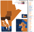
 Manitoba general election 2016 - Winning party vote by riding
 -
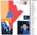
 Manitoba general election 2019 - Winning party vote by riding
 -
 Manitoba general election 2023 - Winning party vote by riding


Maps of Ontario
editOntario Provincial Election 2018
edit-
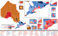
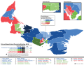
 Ontario general election 2018 - Results by Riding

Ontario Provincial Election 2018 - Party Vote Strength Maps
edit-
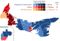
 Ontario general election 2018 - Progressive Conservative vote strength by Riding
 -
 Ontario general election 2018 - NDP vote strength by Riding
 -
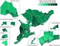
 Ontario general election 2018 - Liberal vote strength by Riding


Ontario Provincial Election 2014
edit-
 Ontario general election 2014 - Winning party vote by riding
 -
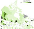
 Ontario general election 2014 - Voter Turnout by riding
 -
 By-Elections to the Ontario 41st Legislature (2014-2018)


Ontario Provincial Election 2014 - Party Vote Strength Maps
edit-
 Ontario general election 2014 - Liberal Party Vote Strength By Riding (🚩co-authored by Mr.Election)
 -
 Ontario general election 2014 - Progressive Conservative Party Vote Strength By Riding
 -
 Ontario general election 2014 - New Democratic Party Vote Strength By Riding
 -
 Ontario general election 2014 - Green Party Vote Strength By Riding (🚩co-authored by Mr.Election)
 -
 Ontario general election 2014 - Libertarian Party Vote Strength By Riding (🚩co-authored by Mr.Election)


Ontario Provincial Election 2011
edit-
 Ontario general election 2011 - Winning party vote by riding (🚩 Map re-edit co-authored by Mr.Election)

Ontario Provincial Election 2011 - Party Vote Strength Maps
edit-
 Ontario general election 2011 - Liberal Party Vote Strength By Riding (🚩co-authored by Mr.Election)
 -
 Ontario general election 2011 - Progressive Conservative Party Vote Strength By Riding
 -
 Ontario general election 2011 - New Democratic Party Vote Strength By Riding


Ontario Provincial Election 2007
edit-
 Ontario general election 2007 - Winning party vote by riding
 -
 Ontario Alternative Vote Referendum 2007 - Results by riding


Ontario Provincial Election 2007 - Party Vote Strength Maps
edit-
 Ontario general election 2007 - Liberal Party Vote Strength By Riding (🚩co-authored by Mr.Election)
 -
 Ontario general election 2007 - Green Party Vote Strength By Riding (🚩co-authored by Mr.Election)


Other Ontario Provincial Elections
edit-
 Ontario general election 1987 - Winning party vote by riding (🚩co-authored by Mr.Election)
 -
 Ontario general election 1990 - Winning party vote by riding
 -
 Ontario general election 1995 - Winning party vote by riding
 -
 Ontario general election 1999 - Winning party vote by riding (🚩co-authored by Mr.Election)
 -
 Ontario general election 2003 - Winning party vote by riding


Ontario Party Leadership Elections
edit-
 Ontario Progressive Conservative Party Leadership Election 2015 - Winning candidate by riding
 -
 Ontario Progressive Conservative Party Leadership Election 2018 - Winning candidate by riding


Maps of Quebec
editQuebec Provincial Election 2018
edit
Quebec Provincial Election 2014
editTo see additional maps of Quebec, please visit Mr.Election's Wikimedia page.
-
 Quebec general election 2014 - Winning party vote by riding
 -
 By-Elections to the Quebec 41st National Assembly (2014-2018) (🚩co-authored by Mr.Election)


Other Quebec Provincial Election Maps
edit-
 Quebec general election 1994 - Winning party vote by riding (🚩co-authored by Mr.Election)
 -
 Quebec general election 1998 - Winning party vote by riding (🚩co-authored by Mr.Election)
 -
 Quebec general election 2003 - Winning party vote by riding (🚩co-authored by Mr.Election)
 -
 Quebec general election 2007 - Winning party vote by riding
 -
 Quebec general election 2008 - Winning party vote by riding
 -
 Quebec general election 2012 - Winning party vote by riding


Quebec Referendum Maps
edit-
 Quebec independence referendum 1995 - Vote by riding
 -
 Quebec independence referendum 1995 - Vote by riding (Simple)

.svg)
Maps of New Brunswick
editTo see additional maps of New Brunswick, please visit Mr.Election's Wikimedia page.
-
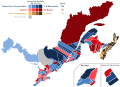
 New Brunswick general election 1978 - Winning party vote by riding
 -
 New Brunswick general election 1987 - Winning party vote by riding
 -
 New Brunswick general election 2006 - Winning party vote by riding
 -
 New Brunswick general election 2010 - Winning party vote by riding
 -
 New Brunswick general election 2014 - Winning party vote by riding
 -
 New Brunswick general election 2018 - Winning party vote by riding
 -
 New Brunswick general election 2020 - Winning party vote by riding


Maps of Prince Edward Island
editTo see additional maps of Prince Edward Island, please visit Mr.Election's Wikimedia page.
-
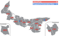
 Prince Edward Island general election 1982 - Results by District
 -
 Prince Edward Island general election 1986 - Results by District
 -
 Prince Edward Island general election 1989 - Results by District
 -
 Prince Edward Island general election 1993 - Results by District
 -
 Prince Edward Island general election 1996 - Winning party vote by riding
 -
 Prince Edward Island general election 2000 - Winning party vote by riding
 -
 Prince Edward Island general election 2003 - Winning party vote by riding
 -
 Prince Edward Island general election 2007 - Winning party vote by riding
 -
 Prince Edward Island general election 2011 - Winning party vote by riding
 -
 Prince Edward Island general election 2015 - Winning party vote by riding
 -
 Prince Edward Island general election 2019 - Winning party vote by riding
 -
 Prince Edward Island Electoral Reform Referendum 2019 - Winning Vote by Riding


Maps of Nova Scotia
edit-
 Nova Scotia general election 2003 - Winning party vote by riding (🚩co-authored by Mr.Election)
 -
 Nova Scotia general election 2006 - Winning party vote by Riding
 -
 Nova Scotia general election 2009 - Winning party vote by Riding
 -
 Nova Scotia general election 2013 - Winning party vote by Riding
 -
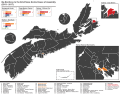 By-Elections to the 62nd Legislature of Nova Scotia (2013-2017)
 -
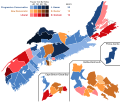
 Nova Scotia general election 2017 - Winning party vote by Riding
 -
 Nova Scotia general election 2021 - Winning party vote by Riding


.svg)


Maps of Newfoundland & Labrador
edit-
 Newfoundland & Labrador general election 1999 - Winning party vote by riding
 -
 Newfoundland & Labrador general election 2003 - Winning party vote by riding
 -
 Newfoundland & Labrador general election 2007 - Winning party vote by riding
 -
 Newfoundland & Labrador general election 2011 - Winning party vote by riding
 -
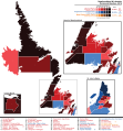 Newfoundland & Labrador general election 2015 - Winning party vote by riding
 -
 Newfoundland & Labrador general election 2019 - Winning party vote by riding
 -
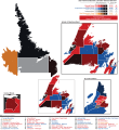 Newfoundland & Labrador general election 2021 - Winning party vote by riding


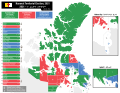
Maps of the Canadian Territories
editYukon Election Maps
edit-
 Yukon general election 1978 - Winning party vote by riding
 -
 Yukon general election 1982 - Winning party vote by riding
 -
 Yukon general election 1985 - Winning party vote by riding
 -
 Yukon general election 1989 - Winning party vote by riding
 -
 Yukon general election 1992 - Winning party vote by riding
 -
 Yukon general election 1996 - Winning party vote by riding
 -
 Yukon general election 2000 - Winning party vote by riding
 -
 Yukon general election 2002 - Winning party vote by riding
 -
 Yukon general election 2006 - Winning party vote by riding
 -
 Yukon general election 2011 - Winning party vote by riding
 -
 Yukon general election 2016 - Winning party vote by riding
 -
 Yukon general election 2021 - Winning party vote by riding


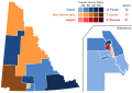
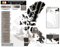
Northwest Territories & Nunavut Election Maps
edit-
 Northwest Territories general election 2015 - Winning party vote by riding
 -
 Nunavut general election 2013 - Winning party vote by riding
 -
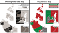
 Nunavut general election 2017 - MLA Incumbency Map Post Election
 -
 Nunavut general election 2021 - Winning party vote by riding
 -
 Nunavut general election 2021 - MLA Incumbency Map Post Election


Other Canadian Election Maps
editToronto Mayoral Election Maps
edit-
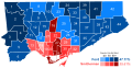 Toronto mayoral election 2010 - Winning candidate by ward
 -
 Toronto mayoral election 2014 - Winning candidate by ward


Windsor, ON Ward/Municipal Maps
edit-
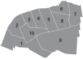 Windsor Ward Map
 -
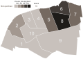 Windsor municipal election 2014 - Winning candidate by ward


2022 Windsor, Ontario Municipal Election Maps
edit-
Winning candidate vote strength by Ward and Polling district
-
 Drew Dilkens vote strength by Ward and Polling district
 -
 Chris Holt vote strength by Ward and Polling district
 -
 Voter turnout by Ward and Polling district


Maps of the United Kingdom & Ireland
editUnited Kingdom General Election 2017 Maps
editUnited Kingdom 2017 Election Maps By NUTS Region
edit-
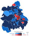
 United Kingdom general election 2017 - Winning party vote by constituency (London)
 -
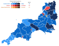 United Kingdom general election 2017 - Winning party vote by constituency (South West England)
 -
 United Kingdom general election 2017 - Winning party vote by constituency (North East England)
 -
 United Kingdom general election 2017 - Winning party vote by constituency (South East England)
 -
 United Kingdom general election 2017 - Winning party vote by constituency (West Midlands)
 -
 United Kingdom general election 2017 - Winning party vote by constituency (North West England)
 -
 United Kingdom general election 2017 - Winning party vote by constituency (Yorkshire and the Humber)
 -
 United Kingdom general election 2017 - Winning party vote by constituency (East of England)
 -
 United Kingdom general election 2017 - Winning party vote by constituency (East Midlands)
.svg)
.svg)
.svg)
.svg)
.svg)
.svg)
.svg)
.svg)
.svg)
Maps of Scotland
editMap of Scottish Parliament Elections
edit-
 Scottish parliament election 1999 - Winning party vote by constituency & regional seats
 -
 Scottish parliament election 2003 - Winning party vote by constituency & regional seats
 -
 Scottish parliament election 2007 - Winning party vote by constituency & regional seats
 -
 Scottish parliament election 2011 - Winning party vote by constituency & regional seats (🚩co-authored by Mr.Election)
 -
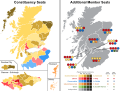
 Scottish parliament election 2016 - Winning party vote by constituency & regional seats


Maps of Wales
editMap of Welsh Parliament Elections
edit-
 Welsh assembly election 1999 - Winning party vote by constituency & regional seats
 -
 Welsh assembly election 2003 - Winning party vote by constituency & regional seats (🚩co-authored by Mr.Election)
 -
 Welsh assembly election 2007 - Winning party vote by constituency & regional seats
 -
 Welsh assembly election 2011 - Winning party vote by constituency & regional seats (🚩co-authored by Mr.Election)
 -
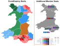 Welsh assembly election 2016 - Winning party vote by constituency & regional seats


Maps of Northern Ireland
editMap of Northern Ireland Assembly Elections
edit-
 Northern Ireland assembly election 1998 - Winning party by constituency seats
 -
 Northern Ireland assembly election 2003 - Winning party by constituency seats
 -
 Northern Ireland assembly election 2007 - Winning party by constituency seats
 -
 Northern Ireland assembly election 2011 - Winning party by constituency seats
 -
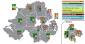 Northern Ireland assembly election 2016 - Winning party by constituency seats


Maps of London
editMap of London Assembly Elections
edit-
 London assembly election 2000 - Winning party vote by constituency & regional seats
 -
 London assembly election 2004 - Winning party vote by constituency & regional seats
 -
 London assembly election 2008 - Winning party vote by constituency & regional seats
 -
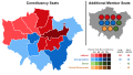 London assembly election 2012 - Winning party vote by constituency & regional seats
 -
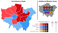 London assembly election 2016 - Winning party vote by constituency & regional seats


Maps of the Republic of Ireland
editMap of Ireland general elections
edit-
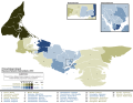
 Ireland general election 2011 - Winning party seats by electoral region
 -
 Ireland general election 2016 - Winning party seats by electoral region
 -
 Ireland general election 2016 - Blank map of constituencies


Maps of Australia & New Zealand
editMaps of Australia & New Zealand Federal Elections
editAustralia Election 2019
edit-
 Australia Federal Election 2016 - Winning Party By Division
 -
 Australia Federal Election 2016 - First Party Preference Vote By Division
 -
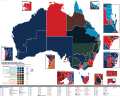 Australia Federal Election 2016 - Two-Party Preferred Vote By Division


Australia Election 2016
edit-
 Australia Federal Election 2016 - Winning Party By Division
 -
 Australia Federal Election 2016 - First Party Preference Vote By Division
 -
 Australia Federal Election 2016 - Two-Party Preferred Vote By Division
 -
 Australia Federal Election 2016 - Blank Map of Electoral Divisions
 -
 Australia Federal Election 2016 - Senate Results by Winning Party
.svg)


.svg)

New Zealand Elections
edit-
 New Zealand general election 2014 - Winning party vote by constituency & regional seats
 -
 New Zealand flag referendum 2016 - Winning flag vote by constituency (🚩co-authored by Mr.Election)
 -
 New Zealand general election 2017 - Winning party vote by constituency & regional seats


Maps of Australian States & Territories
editWestern Australia
edit-
 Western Australia Legislative Council Election 2017 - Winning party seats by electoral region

Northern Territory
edit-
 Northern Territory election 2016 - Winning Party By Division
 -
 Northern Territory election 2016 - First Party Preference & Two Party Preferred Vote by division.
 -
 Northern Territory election 2016 - Blank Map of Electoral Divisions
.svg)

.svg)
South Australia
edit-
 South Australia election 2014 - Winning Party By Division
 -
 South Australia election 2014 - First Party Preference & Two Party Preferred Vote by division.
.svg)
.svg)
New South Wales
edit-
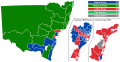 New South Wales state election 2015 - Winning Party By Division
 -
 New South Wales state election 2015 - First Party Preference Vote & Two-Party Preferred Vote By Division


Victoria
edit-
 Victoria state election 2014 - Winning Party By Division
 -
 Victoria state election 2014 - First Party Preference Vote & Two-Party Preferred Vote By Division
.svg)
.svg)
Tasmania
edit-
 Tasmania state election 2015 - Winning party seats by electoral region

Australian Capital Territory (ACT)
edit-
 Australian Capital Territory election 2016 - Winning party seats by electoral region

Maps of the United States of America
editState Legislature Election Maps (2016 Election)
edit-
 Hawaii House of Representatives Election 2016 - Results By District
 -
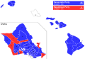 Hawaii House of Representatives Election 2016 - Results By District (Simple Colors)
 -
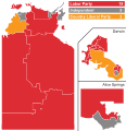
 Idaho House of Representatives Election 2016 - Results By District
 -
 Idaho Senate Election 2016 - Results By District
 -
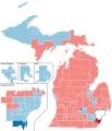 Michigan House of Representatives Election 2016 - Results By District
 -
 Michigan House of Representatives Election 2016 - Results By District (Simple Colors)
 -
 Oregon House of Representatives Election 2016 - Results By District (Simple Colors)

.svg)


.svg)
City Council Elections
edit-
 New York City City Council Election 2013 - Winning party vote by district
 -
 Chicago Aldermanic Council Election 2015 - Winning party vote by ward


2016 House of Representatives Election
edit-
 United States House of Representatives Election (Colorado) - Winning party vote by district
 -
 United States House of Representatives Election (Arizona) - Winning party vote by district
 -
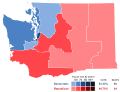 United States House of Representatives Election (Washington) - Winning party vote by district


Maps of Other Countries
editArgentinian Election Maps
edit-
 Argentinean general election 2017 - Chamber of Deputies results by province
 -
 Argentinean general election 2017 - Chamber of Senators results by province


The Bahamas Election Maps
edit-
 The Bahamas general election 2017 - Winning party vote by constituency

Belize Election Maps
edit-
 Belize general election 2008 - Winning party vote by constituency
 -
 Belize National Referendum 2008 - Winning vote by constituency
 -
 Belize general election 2012 - Winning party vote by constituency
 -
 Belize general election 2015 - Winning party vote by constituency


Bermuda Election Maps
edit-
 Bermuda general election 2017 - Winning party vote by constituency

Costa Rica Election Maps
edit-
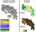
 Costa Rica Presidential & Legislative Election 2002
 -
 Costa Rica Presidential & Legislative Election 2006
 -
 Costa Rica Presidential & Legislative Election 2010
 -
 Costa Rica Presidential & Legislative Election 2014


Czech Republic Election Maps
edit-
 Czech Republic general election 2017 - Results by Region

Falkland Islands Election Maps
edit-
 Falkland Islands general election 2017 - Results by Constituency

Germany Election Maps
edit-
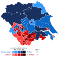
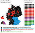
 Germany federal election 2013 - Winning party by constituency & regional seats
 -
 Germany federal election 2017 - Winning party by constituency & regional seats
 -
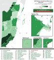
 Germany federal election 2017 - Additional Member seats by State


Iceland Election Maps
edit-
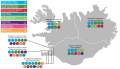 Iceland general election 2017 - Results by Constituency

Jamaica Election Maps
edit-
 Jamaica general election 2011 - Winning party vote by constituency
 -
 Jamaica general election 2016 - Winning party vote by constituency
 -
 Jamaica House of Representative Constituency Map (2011 & 2016 Elections) (Blank)


.svg)
Lesotho Election Maps
edit-
 Lesotho general election 2017 - Winning party by constituency & regional seats

Malta Election Maps
edit-
 Malta general election 2017 - Results by District

Poland Election Maps
edit
South Africa Election Maps
edit-
 Results by province of the South Africa Republic Referendum in 1960
 -
 South Africa Bantustans Map


Trinidad & Tobago Election Maps
edit-
 Trinidadian general election 2015 - Results by Constituency

Outdated & Retired Maps
editThis section contains election maps I have created in the past that are no longer in use, or have been updated by a more professionally done version of the same map. Many of these are from my early days of map-making.
-
 Belize general election 2015 - Winning party vote by constituency (🚩co-authored by Mr.Election)
 -
 Nova Scotia general election 2013
 -
 Ontario electoral ridings (2007 - 2018)
 -
 Yukon general election 2011
 -
 Yukon general election 2016
 -
 Newfoundland & Labrador general election 2015
 -
 Ontario general election 2014
 -
 London Assembly Election 2000
 -
 London Assembly Election 2004
 -
 London Assembly Election 2008
 -
 London Assembly Election 2012
 -
 London Assembly Election 2016
 -
 Australia Federal Election 2016 - Winning Party By Division
 -
 Australia Federal Election 2016 - Blank Map of Electoral Divisions
 -
 Australia Federal Election 2016 - Winning Party By Division
 -
 Australia Federal Election 2016 - First Party Preference Vote By Division
 -
 Australia Federal Election 2016 - Two-Party Preferred Vote By Division
 -
 Australia Federal Election 2016 - Blank Map of Electoral Divisions
 -
 Northern Territory election 2016 - First Party Preference Vote By Division
 -
 Northern Territory election 2016 - Two-Party Preferred Vote By Division
 -
 Germany federal election 2013 - Results By Constituency


.svg)


.svg)
.svg)

.svg)
.svg)

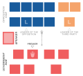
Legislature Seating Plan Diagrams
editThis section contains the seating plans of many Legislative Assemblies. Most of them are provincial/territorial legislatures from my native Canada. Some city council charts are in here as well.
NOTE - The files state the date at which the most recent election occurred. Many of these maps have had small changes made to them over time due to by-elections and defections - some by myself, some by other Wikimedia users..
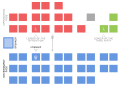
Canadian Federal Parliaments
edit-
 Canadian House of Commons Seating Plan (2015-present)
 -
 Canadian Senate Seating Plan (2015-present)
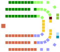
Canadian Provincial Legislatures
edit-
 British Columbia Legislative Assembly Seating Plan
 -
 Alberta Legislative Assembly Seating Plan)
 -
 Saskatchewan Legislative Assembly Seating Plan
 -
 Manitoba Legislative Assembly Seating Plan
 -
 Ontario Legislative Assembly Seating Plan
 -
 Quebec National Assembly Seating Plan
 -
 Nova Scotia House of Assembly Seating Plan
 -
 Prince Edward Island Legislative Assembly Seating Plan
 -
 New Brunswick Legislative Assembly Seating Plan
 -
 Newfoundland & Labrador House of Assembly Seating Plan
.svg)


Canadian Territorial Legislatures
edit-
 Yukon Legislative Assembly Seating Plan (2016 - present)
 -
 Northwest Territories Legislative Assembly Seating Chart
 -
 Nunavut Legislative Assembly Seating Chart


Other Legislatures
edit-
 Bahamas House of Assembly Seating Plan (2017-present)
 -
 Bahamas Senate Seating Plan (2017-present)
 -
 New Zealand House of Representatives Seating Plan (2017-present)
 -
 Northern Ireland Assembly Seating Plan (March 2017 - present)


Political Logos
editSome of my earliest SVG work was making logos of different political parties. Aside from map-making, it is still something I do from time to time. Here is all of them.
-
 Conservative Party of Canada Logo (English and French) (2018 - present)
 -
 Alberta New Democratic Party (NDP) Logo
 -
 United Conservative Party (Alberta) Logo
 -
 Manitoba Party Logo
 -
 Progressive Conservative Party of Manitoba Logo
 -
 Manitoba New Democratic Party (NDP) Logo
 -
 Northern Ontario Party Logo
 -
 Ontario Progressive Conservative Party Logo (2010-2016)
 -
 Ontario Progressive Conservative Party Logo (2016-present)
 -
 Action_démocratique_du_Québec Party Logo
 -
 New Brunswick New Democratic Party (NDP) Logo
 -
 Prince Edward Island Progressive Conservative Party Logo
 -
 Yukon New Democratic Party (NDP) Logo
.svg)
.svg)
SVG Flags
editHere are some flags I have converted from .jpeg files to .svg files.
-
 Flag of the Afro-Nova Scotian community.
 -
 Flag of Elgin County, Ontario
 -
 Flag of Essex County, Ontario (1970s?-2014)
 -
 Flag of Essex County, Ontario (2014-present)
 -
 Flag of the Town of Essex, Ontario
 -
 Flag of the Town of Lakeshore, Ontario
 -
 Flag of Amherstburg, Ontario
 -
 Flag of Tecumseh, Ontario
 -
 Flag of Kingsville, Ontario
 -
 Flag of LaSalle, Ontario
 -
 Flag of Leamington, Ontario
 -
 Flag of Orillia, Ontario
 -
 Flag of St. Thomas, Ontario
 -
 Flag of Cape Breton Island, Nova Scotia (Tartan)
 -
 Flag of Cape Breton Island, Nova Scotia (Eagle)
 -
 Flag of Cape Breton Island, Nova Scotia (popular unofficial)
 -
 Flag of Cape Breton Island, Nova Scotia (Original Blue Design)
 -
 "The New Magnolia" Mississippi Flag Winner
 -
 "Detroit Rise" flag proposal for Detroit by Deon Mixon.
 -
 Canadian Broadcasting Corporation (CBC) corporate flag.


.svg)
.svg)


.svg)
.svg)
.svg)
.svg)


Frequently Asked Questions (FAQ's)
editQ: What program do you use to make the maps?
A: I use Adobe Illustrator (AI). Any vector program would work such as GIMP or InkScape, but I have always preferred to use AI.
Q: What was the first election map you made?
A: It's not on Wikimedia because of how bad it was but it was a map of Yukon's 2011 election. It was appallingly bad since it was traced with the "Image Trace" tool as opposed to me tracing it by hand. Even the vote strength chart was traced like this and the colours ended up looking washed out and horrid. It was awful at the time but I remember thinking it looked pretty cool. The first one I uploaded to Wikimedia was my first design of the Ontario 2014 election map. The original design is under the "Outdated and Retired Maps" if you want to check it out. Since then, Ive redesigned the Ontario election maps 4 times.
Q: How long does it take to make a map?
A: It depends on the complexity of the map and how many problems with Adobe Illustrator I encounter! Smaller maps can take anywhere from 2-4 hours to make, while some of the larger and more complex maps can take a total of 10 hours of work (working on and off, of course). The 2015 Canada election map took about 13 hours to make, since it was my first major map.
Q: What is your most favourite map that you made?
A: I would have to say my Canada 2015 map. It was my first major project and even though it could use some improvements, Im still happy with how it turned out.
Q: What is your least favourite map that you made?
Im not gonna answer that :P
Q: Are you partners with Mr.Election?
A: When it comes to map-making absolutely, were a team! We have our own logo! He's a great friend, and we work together on many maps, and its the reason we've been able to make so many so quickly.
Q: Can I request a map to be made?
A: Absolutely! I do take requests for maps. I dislike the Wikimedia chat system so I prefer if you email suggestions to my personal email riley.richard1095@gmail.com. I will try to respond as quickly as I can. That being said there are some maps I cannot do, such as for a lack of reliable data on election numbers or a lack of an accurate existing boundaries map for me to base my maps off of.
Q: Where do you get the electoral data for your maps?
A: This depends on what country I am doing. If I am doing Canada or any of the provinces, I get my data from http://www.election-atlas.ca/fed/. Its a wonderful site that gives you a full listing of borders of constituencies from elections past (many of my maps are traced directly off of that site's map), who ran in each constituency, and the vote totals. Really a wonderful site. For other countries, I mostly rely on data from their respective Wikipedia pages, or even external data sites.
Q: Do you charge anything for maps?
A: For Wikimedia uploads, no. Those are fair game for anyone to use (with credit, preferably :P)
That being said, if anyone wants any custom maps, send me an e-mail, and I'd be more than happy to negotiate a price.
Q: Do you work in graphic design?
A: No, but I wish I did. I mostly do this as a hobby. I really don't have any formal graphic design training, I'm pretty much mostly self-taught.
Q: What do you do outside of map making?
A: Nothing interesting to be totally honest (laughs)! I like to keep informed of current events. I do love video games, and I own several systems. Most of what I like to do is related to technology these days.
Q: Where did you get your style of making maps?
A: I will be 100% honest, the style is copied. On each of the Canadian federal election Wikipedia pages, there is a map showing the seat count by provinces, and the different shades of colours representing the strength of the vote in each province. I ended up basing my map design off of those designs.
I ended up keeping that style when I made my maps, the reason being its simple, easy to make, and easily readable.
Q: Can I use your map(s)?
A: Absolutely! Thats why they are on Wikimedia, so people can use them for what they need them for. I only ask that myself (or Mr.Election if he had a hand in making the map) are given credit where credit is due.