Sadalmelik
Joined 5 May 2007
Just a collection of images I have made.
Topographic maps
edit- Red caption means the image should be regenerated for some reason. All of Asia & South-America & Islands should also be regenerated (too ugly/dark)
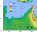
- Egypt: Israeli borders
- Israel, Lebanon, Syria, Jordan: Golan
- Libya: forgot negtweak
- Saudi Arabia: Yemeni border
- Zambia: too dark lakes
- Yemen: border line is not correct
- Blue caption means that there is something fishy about the coastline.
- The list is not complete for these; without getting better coastline data I cannot fix this
African countries
edit-
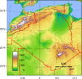 Algeria
 -
 Angola
 -
 Benin
Benin -
 Botswana
 -
 Burkina Faso
 -
 Burundi
 -
 Cameroon
 -
 Central African Republic
 -
 Chad
Chad -
 the Republic of the Congo
 -
 the Democratic Republic of the Congo
 -
 Djibouti
 -
 Egypt
Egypt -
 Eritrea
 -
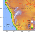
 Ethiopia
 -
 Gabon
Gabon -
 Ghana
Ghana -
 Guinea-Bissau
 -
 Guinea
 -
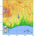 Ivory Coast
 -
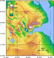
 Kenya
Kenya -
 Lesotho
 -
 Liberia
 -
 Libya
Libya -
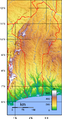
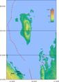
 Madagascar
 -
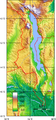 Malawi
 -
 Mali
Mali -
 Mauritania
 -
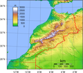 Morocco
 -
 Mozambique
 -
 Namibia
 -
 Niger
Niger -
 Nigeria
 -
 Rwanda
 -
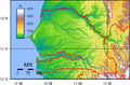 Senegal
 -
 Sierra Leone
 -
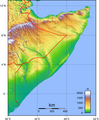 Somalia
 -
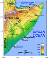 Somalia – with text
 -
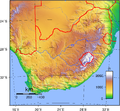 South Africa
 -
 Sudan
Sudan -
 Swaziland
 -
 Tanzania
 -
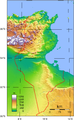 Tunisia
 -
 Togo
Togo -
 Uganda
 -
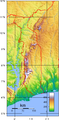
 Western Sahara
 -
 Zambia
 -
 Zimbabwe


Asian countries
edit-
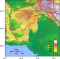
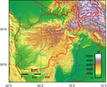 Afghanistan
 -
 Armenia
 -
 Azerbaijan
 -
 Bahrain
 -
 Cambodia
 -
 Georgia
 -
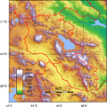
 Iran
Iran -
 Iraq
Iraq -
 Israel
 -
 Jordan
 -
 Kuwait
 -
 Kyrgyzstan
 -
 Laos
Laos -
 Lebanon
 -
 Mongolia
 -
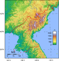 North Korea
 -
 Oman
Oman -
 Qatar
Qatar -
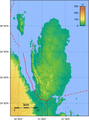
 Pakistan
 -
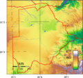
 Saudi Arabia
 -
 South Korea
 -
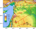 Syria
Syria -
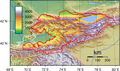
 Tajikistan
 -
 Thailand
 -
 Turkmenistan
 -
 United Arab Emirates
 -
 Uzbekistan
 -
 Vietnam
 -
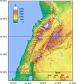
 Yemen
Yemen


American countries
edit-
 Belize
 -
 Bolivia
 -
 Colombia
 -
 Costa Rica
 -
 Cuba
Cuba -
 Ecuador
 -
 El Salvador
 -
 Guatemala
 -
 Honduras
 -
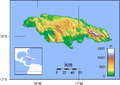 Jamaica
 -
 Nicaragua
 -
 Panama
 -
 Peru
Peru -
 Suriname
 -
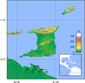 Trinidad and Tobago
 -
 Venezuela


Islands
edit-
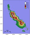
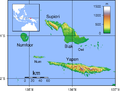
 Bali
Bali -
 Bangka
 -
 Belitung
 -
 Bougainville
 -
 Choiseul
 -
 Fergusson Island
 -
 Flores
 -
 Goodenough Island
 -
 Guadalcanal
 -
 Halmahera
 -
 Lombok
 -
 Madura
 -
 Makira
 -
 Malaita
 -
 Morotai
 -
 New Britain
 -
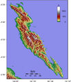
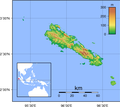
 New Caledonia
 -
 New Ireland
 -
 Nias
Nias -
 Normanby Island
 -
 Santa Isabel
 -
 Simeulue
 -
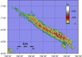
 Sumba
Sumba -
 Sumbawa


_Topography.png)


Island Groups
editIf these contain large islands, each large island should also have a separate map.
-
 Admiralty Islands
 -
 Islands near Bacan
 -
 Banggai Islands
 -
 Islands near Buton
 -
 D'Entrecasteaux Islands
 -
 Feni Islands
 -
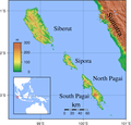 Mentawai Islands
 -
 Obi Islands
 -
 Schouten Islands in Indonesia
 -
 Schouten Islands in Papua New Guinea
 -
 Sula Islands


_Topography.png)
_Topography.png)

Big Islands/Regions
edit-
 Borneo
 -
 Java
Java -
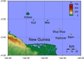
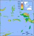
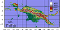 New Guinea
 -
 Sulawesi
 -
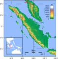 Sumatra


Topographic locator maps
edit-
 Borneo
 -
 Java
Java -
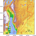
 Maluku
 -
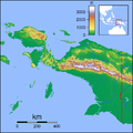 Papua
Papua -
 Sulawesi
 -
 Sumatra


Other maps
editSri Lanka
edit-
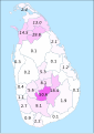
 Buddhists
 -
 Christians
 -
 Hindus
 -
 Muslims
 -
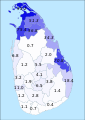
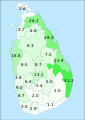
 Sinhalese
 -
 Tamils of Sri Lankan origin
 -
 Tamils of Indian origin
 -
 Sri Lankan Moors
 -
 Burghers
 -
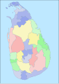 Location map


Misc Images
edit-
 Radama II, King of Madagascar
