Category:1750s maps of Peru
Media in category "1750s maps of Peru"
The following 7 files are in this category, out of 7 total.
-
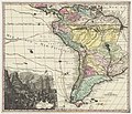
 Carte du paraguay et del pays voisins Echelle 1756.jpg 1,749 × 1,230; 532 KB
-
 ConsulterElementNum.jpg 680 × 413; 142 KB
-
 Lake-Titicaca-Jacques-Nicolas-Bellin-1758.jpg 640 × 480; 108 KB
-
-
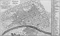
 Plano del Callao LOC 90682889.jpg 5,483 × 4,155; 3.65 MB
-
 Plano del Callao LOC 90682889.tif 5,483 × 4,155; 65.18 MB
-
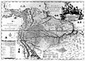 Provincia de Quitensis, Novo Regni Granatensis et Peruana (1751) - AHG.jpg 4,786 × 3,426; 8.11 MB


.jpg)

_-_AHG.jpg)