Category:1794 maps of Canada
| 1790 1791 1792 1793 1794 1795 1797 1798 → |
English: Maps of Canada from 1794 or related to Canada in 1794
Français : Les cartes du Canada de 1794 ou se rapportant au Canada en 1794
Media in category "1794 maps of Canada"
The following 10 files are in this category, out of 10 total.
-

-

-

-
 A new map of Nova Scotia, New Brunswick and Cape Breton, 1794. NYPL1567516.tiff 6,598 × 5,428; 102.47 MB
-
 A new map of Upper and Lower Canada, 1794. NYPL1567515.tiff 6,598 × 5,428; 102.47 MB
-
-
 A new map of Upper and Lower Canada, 1794 (NYPL b14115138-1567515).jpg 6,598 × 5,428; 4.57 MB
-

-
 Part of Newfoundland (3046334048).jpg 1,607 × 2,000; 3.1 MB
-
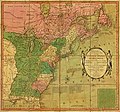
 The United States of America with the British possessions of Canada... (2675149092).jpg 2,000 × 1,487; 2.37 MB

.jpg)
.jpg)
.jpg)
.jpg)