Category:1794 maps of the United States
Subcategories
This category has the following 6 subcategories, out of 6 total.
Media in category "1794 maps of the United States"
The following 24 files are in this category, out of 24 total.
-
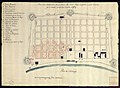 1794 mapa incendio Nueva Orleans AGI.jpg 2,096 × 1,530; 559 KB
-
 A map of the back settlements - DPLA - 2af5a3d3756e0d7fd0fbd2afed5038d9.jpg 1,000 × 759; 182 KB
-

-

-

-

-

-

-

-
 Map of the state of Kentucky - with the adjoining territories LOC 2007630404.jpg 5,723 × 4,751; 3.87 MB
-
 Map of the state of Kentucky - with the adjoining territories LOC 2007630404.tif 5,723 × 4,751; 77.79 MB
-

-
 Map of Virginia, Maryland and Delaware (NYPL b14115138-1567529).jpg 7,230 × 5,428; 6.09 MB
-
 Map of Virginia, Maryland and Delaware (NYPL b14115138-1567529).tiff 7,230 × 5,428; 112.28 MB
-
 A map of the Back Settlements (NYPL b14115138-1567530).jpg 6,598 × 5,428; 4.56 MB
-

-
 Map of the middle states of America (NYPL b15072758-434890).tiff 5,274 × 4,304; 64.95 MB
-
 Map of the United States of America (NYPL b15072779-434049).tiff 4,000 × 3,093; 35.4 MB
-
 Map of Virginia, Maryland and Delaware (NYPL b15317432-976263).tiff 6,251 × 4,080; 72.97 MB
-

-

-
 The United States of America with the British possessions of Canada... (2675149092).jpg 2,000 × 1,487; 2.37 MB
-
 Washington DC 1794-.jpg 3,593 × 2,791; 1.19 MB
-
 Washington DC 1794.jpg 4,615 × 4,012; 3.25 MB


.jpg)

.jpg)

.jpg)
.jpg)
.jpg)
.jpg)
.jpg)
.jpg)
.jpg)

