Category:Aerial photographs of Oxfordshire
Ceremonial counties of England: Bedfordshire · Berkshire · Buckinghamshire · Cambridgeshire · Cheshire · Cornwall · Cumbria · Derbyshire · Devon · Dorset · Durham · East Riding of Yorkshire · East Sussex · Essex · Gloucestershire · Greater London · Greater Manchester · Hampshire · Herefordshire · Hertfordshire · Isle of Wight · Kent · Lancashire · Leicestershire · Lincolnshire · Merseyside · Norfolk · North Yorkshire · Northamptonshire · Northumberland · Nottinghamshire · Oxfordshire · Shropshire · Somerset · South Yorkshire · Staffordshire · Suffolk · Surrey · Tyne and Wear · Warwickshire · West Midlands · West Sussex · West Yorkshire · Wiltshire · Worcestershire
City-counties: Bristol · City of London
Former historic counties: Middlesex · Sussex · Yorkshire
Other former counties:
City-counties: Bristol · City of London
Former historic counties: Middlesex · Sussex · Yorkshire
Other former counties:

Subcategories
This category has the following 2 subcategories, out of 2 total.
O
- Aerial photographs of Oxford (44 F)
Media in category "Aerial photographs of Oxfordshire"
The following 41 files are in this category, out of 41 total.
-
-

-
-

-

-
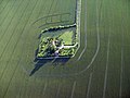
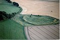 Alfred's Castle, Oxfordshire, aerial view from North.jpg 1,800 × 1,200; 324 KB
-
 Alfred's Castle, Oxfordshire, excavations 1999.jpg 839 × 573; 460 KB
-
 BAe125 aircraft from A Flight of 32 (The Royal) Squadron MOD 45147917.jpg 3,000 × 1,880; 3.87 MB
-
 Banbury from the air.jpg 1,600 × 1,200; 224 KB
-
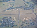
 Bicester Airfield from above - geograph.org.uk - 637350.jpg 600 × 526; 71 KB
-
 Bix Village - geograph.org.uk - 1036962.jpg 640 × 428; 86 KB
-
 Blenheim Palace from the Air - geograph.org.uk - 620690.jpg 635 × 392; 125 KB
-
 Chalgrove-22apr44.png 600 × 535; 335 KB
-
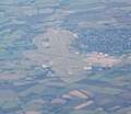
 Didcot in the Haze - geograph.org.uk - 4525525.jpg 1,024 × 768; 68 KB
-
 Didcot power station.jpg 3,072 × 2,304; 3.04 MB
-
 East Ginge from the air - geograph.org.uk - 198185.jpg 640 × 607; 92 KB
-
 Enstone Airfield (30493183044).jpg 2,851 × 2,536; 1.1 MB
-
 Final Flight of RAF Puma HC1 Helicopters MOD 45154821.jpg 4,500 × 3,000; 10.3 MB
-
 Final Flight of RAF Puma HC1 Helicopters MOD 45154822.jpg 4,500 × 3,000; 7.63 MB
-
 Floods in Oxfordshire MOD 45158453.jpg 3,000 × 2,010; 6.43 MB
-
 Former RAF Upper Heyford from the air - geograph.org.uk 2355952.jpg 640 × 480; 144 KB
-
 Grimsbury, Middleton Rd, from the air - geograph.org.uk - 1431827.jpg 640 × 480; 122 KB
-
 Grimsbury, Middleton Road from the air - geograph.org.uk - 1431835.jpg 640 × 480; 117 KB
-
 Grimsbury, School View from the air - geograph.org.uk - 1431832.jpg 640 × 480; 115 KB
-
 Grimsbury, South Street from the air - geograph.org.uk - 1431831.jpg 640 × 480; 112 KB
-
 Harwell Science and Innovation Campus 4677010 f0364f4f.jpg 544 × 408; 97 KB
-
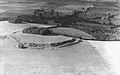
 Mountfarmafld-3jan1946.png 600 × 398; 274 KB
-
 RAF Abingdon (30493182674).jpg 4,000 × 3,000; 1.96 MB
-
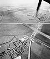 RAF Benson aerial view WWII IWM C 5435.jpg 682 × 800; 84 KB
-
 RAF Brize Norton (30493182934).jpg 2,705 × 2,353; 1.04 MB
-
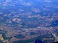 Reading from the air - geograph.org.uk - 2613135.jpg 640 × 480; 180 KB
-
 Royal Air Force Abingdon c1972 - geograph.org.uk - 1428233.jpg 640 × 402; 69 KB
-
 Royal Air Force Bomber Command, 1939-1941. CH1219.jpg 800 × 607; 76 KB
-
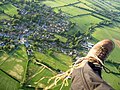
 Shrivenham from glider.jpg 1,151 × 643; 700 KB
-
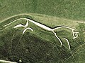 Uffington-White-Horse-sat.jpg 640 × 480; 95 KB
-
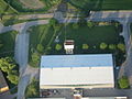
 Williams F1 at Grove.jpg 480 × 640; 101 KB
-
 Williams F1, Grove - geograph.org.uk - 305655.jpg 640 × 480; 106 KB
-
 Witney from above Long Hanborough - geograph.org.uk - 4676827.jpg 3,264 × 2,448; 4.56 MB
-
 Wittenham Clumps from the air, 1939.jpg 300 × 188; 12 KB
-
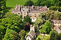 Wytham Abbey Geograph-3504897-by-Dave-Price.jpg 4,211 × 2,797; 3.68 MB
-


_Squadron_MOD_45147917.jpg)


.jpg)


.jpg)

.jpg)


