Category:Maps of Arches National Park
United States national parks: Acadia · American Samoa · Arches · Badlands · Big Bend · Biscayne · Black Canyon of the Gunnison · Bryce Canyon · Canyonlands · Capitol Reef · Carlsbad Caverns · Channel Islands · Congaree · Crater Lake · Cuyahoga Valley · Death Valley · Denali · Dry Tortugas · Everglades · Gateway Arch · Gates of the Arctic · Glacier · Glacier Bay · Grand Canyon · Grand Teton · Great Basin · Great Smoky Mountains · Guadalupe Mountains · Haleakalā · Hawaii Volcanoes · Hot Springs · Indiana Dunes · Isle Royale · Joshua Tree · Kenai Fjords · Kings Canyon · Kobuk Valley · Lake Clark · Lassen Volcanic · Mammoth Cave · Mesa Verde · Mount Rainier · North Cascades · Olympic · Petrified Forest · Pinnacles · Redwood · Rocky Mountain · Saguaro · Sequoia · Shenandoah · Theodore Roosevelt · Virgin Islands · Voyageurs · White Sands · Wind Cave · Wrangell-St. Elias · Yellowstone · Yosemite · Zion
Wikimedia category | |||||
| Upload media | |||||
| Instance of | |||||
|---|---|---|---|---|---|
| Category combines topics | |||||
| Arches National Park | |||||
national park in Grand County, Utah, United States .jpg) .jpg) | |||||
| Instance of | |||||
| Part of | |||||
| Location | Grand County, Utah | ||||
| Visitor center | |||||
| Operator | |||||
| Heritage designation |
| ||||
| IUCN protected areas category | |||||
| Inception |
| ||||
| Highest point | |||||
| Area |
| ||||
| Replaces |
| ||||
| Visitors per year |
| ||||
| official website | |||||
 | |||||
Subcategories
This category has the following 3 subcategories, out of 3 total.
Media in category "Maps of Arches National Park"
The following 21 files are in this category, out of 21 total.
-
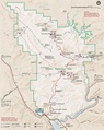
 Arches National Park Map.jpg 2,500 × 3,750; 3.52 MB
-
 Arches National Park.svg 1,000 × 1,000; 12 KB
-
 DinosaurDiamond map.svg 1,475 × 860; 769 KB
-
 Grandcounty ut.png 745 × 778; 35 KB
-
 LocMap Arches National Park.png 280 × 183; 31 KB
-
 Map Arches National Park.jpg 1,337 × 1,720; 638 KB
-
 Map of Arches National Park.png 2,770 × 3,488; 1.2 MB
-
 NPS arches-backpacking-map-2017.jpg 1,003 × 1,293; 247 KB
-
 NPS arches-backpacking-map.jpg 668 × 916; 73 KB
-
 NPS arches-camping-map.jpg 1,592 × 1,892; 516 KB
-
 NPS arches-delicate-arch-map.jpg 920 × 319; 100 KB
-
 NPS arches-devils-garden-map.gif 2,416 × 762; 132 KB
-
 NPS arches-devils-garden-map.jpg 789 × 531; 122 KB
-
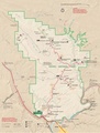
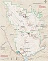 NPS arches-map.jpg 2,739 × 3,439; 1.18 MB
-
 NPS arches-map.pdf 1,641 × 2,062; 2.55 MB
-
 NPS arches-national-park-map.jpg 2,245 × 2,968; 1.56 MB
-
 NPS arches-national-park-map.pdf 1,683 × 2,225; 10.21 MB
-
 NPS arches-national-park-vegetation-map.jpg 2,008 × 2,520; 818 KB
-
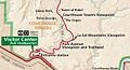 NPS arches-park-avenue-map.jpg 708 × 383; 95 KB
-
 NPS arches-simple-map.gif 1,564 × 2,086; 204 KB
-
 Utah SR 128 map.svg 1,475 × 860; 60 KB


