Category:Maps of the history of Ukraine
Countries of Europe: Albania · Andorra · Armenia‡ · Austria · Azerbaijan‡ · Belarus · Belgium · Bosnia and Herzegovina · Bulgaria · Croatia · Cyprus‡ · Czech Republic · Denmark · Estonia · Finland · France‡ · Georgia‡ · Germany · Greece · Hungary · Iceland · Republic of Ireland · Italy · Kazakhstan‡ · Latvia · Lithuania · Luxembourg · Malta · Moldova · Montenegro · Netherlands‡ · North Macedonia · Norway · Poland · Portugal‡ · Romania · Russia‡ · Serbia · Slovakia · Slovenia · Spain‡ · Sweden · Switzerland · Turkey‡ · Ukraine · United Kingdom
Limited recognition: Abkhazia‡ · Kosovo · South Ossetia‡ · Transnistria · Northern Cyprus‡
‡: partly located in Europe
Limited recognition: Abkhazia‡ · Kosovo · South Ossetia‡ · Transnistria · Northern Cyprus‡
‡: partly located in Europe
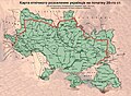
Note: This category provides links to modern maps produced to show historical events that occurred in places now within modern Ukraine.
Wikimedia category | |||||
| Upload media | |||||
| Instance of | |||||
|---|---|---|---|---|---|
| |||||
Subcategories
This category has the following 7 subcategories, out of 7 total.
!
D
H
Media in category "Maps of the history of Ukraine"
The following 102 files are in this category, out of 102 total.
-
 001 Kievan Rus' Kyivan Rus' Ukraine map 1220 1240.jpg 2,301 × 2,856; 4.69 MB
-
 0010 Ans Ukraine.png 937 × 689; 529 KB
-
 0017 Ukraine Paleolit 3.jpg 1,019 × 746; 117 KB
-
 0022 Ukraine Mesolit 1.jpg 1,013 × 744; 162 KB
-
 0025 Ukraine Mesolit 2.jpg 1,014 × 751; 171 KB
-
 0027 Ukraine Mesolit 3.png 937 × 693; 427 KB
-
 0031 Ukraine Neolit 0.png 937 × 693; 360 KB
-
 0034 Ukraine Neolit 2.png 936 × 688; 559 KB
-
 0035 Ukraine Neolit 3.jpg 1,021 × 752; 80 KB
-
 0040 Ukraine Eneolit 1.jpg 1,012 × 749; 136 KB
-
 0042 Ukraine Eneolit 2.jpg 1,012 × 751; 132 KB
-
 0042 Ukraine Eneolit.png 939 × 693; 536 KB
-
 0044 Ukraine Eneolit 3.png 938 × 693; 502 KB
-
 0052 Ukraine Bronze.png 937 × 692; 558 KB
-
 0053 Ukraine Bronze 1.png 937 × 693; 421 KB
-
 0054 Ukr Bronze 1.png 1,651 × 1,220; 948 KB
-
 0057 Ukraine Bronze 4.png 937 × 693; 519 KB
-
 0058 Ukraine Bronze 5.png 938 × 693; 511 KB
-
 0059 Ukraine Bronze 6.png 1,651 × 1,220; 734 KB
-
 007 Ukrainian Cossack Hetmanate and Russian Empire 1751-ar.jpg 1,012 × 1,256; 465 KB
-
 007 Ukrainian Cossack Hetmanate and Russian Empire 1751.jpg 767 × 952; 414 KB
-
 0200 Ukraine Sarmats.png 1,651 × 1,220; 992 KB
-
 0300 Ukraine Chernjahov.png 1,652 × 1,221; 1.24 MB
-
 0300 Ukraine Sarmats.png 1,321 × 976; 917 KB
-
 0600 Skifia.png 1,653 × 1,220; 1.39 MB
-
 0700 Ukraine Antic.png 2,223 × 1,627; 1.38 MB
-
 0729.tiff 5,174 × 3,288; 442 KB
-
 0900 Ukraine Iron1.png 1,332 × 976; 284 KB
-
 Grand Duchy of Lithuania 1430.png 2,013 × 1,724; 263 KB
-
 1764-75 Ukraine Novoros gov.png 1,817 × 1,342; 870 KB
-
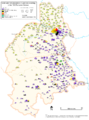
 1876 Украинцы.PNG 1,670 × 987; 1.12 MB
-
 1897 Ukrainians.jpg 1,025 × 640; 299 KB
-
 Alex K Halych-Volhynia 3-es.svg 1,856 × 1,808; 448 KB
-
 Alex K Halych-Volhynia 3.png 1,650 × 1,607; 375 KB
-
 Amount of the Tenth Grosz Contribution in the Polish-Lithuanian Commonwealth in 1790.PNG 2,981 × 3,103; 1.67 MB
-
 Antes01.png 1,243 × 966; 54 KB
-
 Antes02.png 1,243 × 966; 54 KB
-
 Bucov.png 2,100 × 2,830; 1.39 MB
-
 Bucovina division es.svg 1,003 × 1,189; 336 KB
-
 Bucovina division.svg 820 × 1,065; 395 KB
-
 Carte ethnographique de L’Europe Centrale.jpg 3,000 × 2,300; 1.64 MB
-
 Cumania (1200) eng.png 1,141 × 500; 166 KB
-
 Cumania (1200) ukr.png 1,141 × 500; 142 KB
-
 Divisions of Lithuania 1385.svg 735 × 333; 852 KB
-
 DKR map.jpg 291 × 242; 16 KB
-
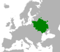
 European Region of Poland.jpg 907 × 560; 103 KB
-
 Europejski Region Polski.jpg 907 × 560; 106 KB
-
 Galicia-Volhynia map.PNG 661 × 655; 41 KB
-
 Galizka Valynskae Knyastva.png 680 × 706; 105 KB
-
 Gdmapretreat.gif 739 × 326; 27 KB
-
 Glacis russe 2014.jpg 924 × 578; 315 KB
-
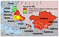
 Green Ukraine - Zeleny Klyn - Russian Federation.jpg 636 × 326; 95 KB
-
 Grody czerwienskie.png 1,684 × 3,130; 1.99 MB
-
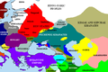
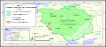
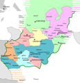
 Historical regions of Ukraine.png 1,181 × 825; 26 KB
-
 Karte Operation Jassy-Kischinew 01.png 654 × 800; 402 KB
-
 Khazarfall1.png 670 × 448; 32 KB
-
 Klesiv1600.jpg 1,179 × 919; 490 KB
-
 Lemko.PNG 320 × 320; 139 KB
-
 Lithuania Territorial Extension 1430.svg 735 × 333; 534 KB
-
 Lwowskie.png 1,052 × 1,018; 89 KB
-
 Makhnovia.svg 1,547 × 1,041; 615 KB
-
 Makhnowia.png 800 × 538; 116 KB
-
 MapaDelPrincipadoDeGalitzia-Volynia.svg 661 × 655; 1.3 MB
-
 Migration of Early Slavs.png 750 × 730; 999 KB
-
 Mitteleuropa ENG Leg wielgórski.PNG 779 × 1,072; 221 KB
-
 Mitteleuropa ENG wielgórski.PNG 779 × 1,072; 212 KB
-
 Mitteleuropa no labels wielgórski.PNG 779 × 1,072; 183 KB
-
 Mitteleuropa POL Leg wielgórski.PNG 779 × 1,072; 211 KB
-
 Mitteleuropa POL wielgórski.PNG 779 × 1,072; 201 KB
-
 Moldova (1483)-en.png 1,769 × 1,614; 4.29 MB
-
 Osterska volost XI-XIII century.jpg 960 × 878; 217 KB
-
 Pale of settlement.jpg 447 × 366; 211 KB
-
 Pale of Settlement00.JPG 2,367 × 2,879; 424 KB
-
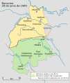
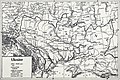
 Partition of Ukraine after the Truce of Andrusovo (1667).jpg 1,040 × 753; 174 KB
-
 PNG Jagelon.png 1,268 × 1,054; 90 KB
-
 Purple Ukraine - Malynovy Klyn - Russian Federation.jpg 636 × 326; 89 KB
-
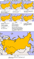 SovietEvolution.png 1,197 × 2,054; 351 KB
-
 SovietEvolutionRus.png 1,197 × 2,054; 577 KB
-
 The Crimean Khanate at its maximum extent (1525).png 2,151 × 1,324; 82 KB
-
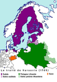 Traité de Varsovie (1705).png 1,110 × 1,600; 115 KB
-
 Ukraine 1920.jpg 3,500 × 2,333; 2.36 MB
-
 Ukraine famine map hu.png 2,848 × 1,744; 717 KB
-
 Ukraine famine map.png 2,848 × 1,744; 680 KB
-
 Ukraine Oldest sityes.PNG 2,424 × 1,790; 2.1 MB
-
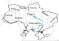
 Ukraine Regions.png 959 × 729; 706 KB
-
 Ukraine-Historical regions-fr.png 684 × 482; 40 KB
-
 Ukraine-Historical regions.png 684 × 482; 101 KB
-
 Ukrainian People's Republic.svg 1,401 × 1,198; 842 KB
-
 Ukrainians in early 20th century (2).png 1,402 × 837; 294 KB
-
 Ukrainians in early 20th century.png 1,402 × 837; 52 KB
-
 UkrainiansInEasterEurope.jpg 670 × 490; 129 KB
-
 White serbia white croatia01.png 870 × 966; 49 KB
-
 White serbia white croatia02.png 870 × 966; 48 KB
-
 Zarubinets culture.jpg 1,027 × 714; 87 KB
-
 Історія будівництва залізниць України.gif 3,224 × 2,196; 571 KB
-
 Зунр.png 493 × 385; 44 KB
-
 История строительства железных дорог Украины.svg 1,433 × 953; 620 KB
-
 Киев1207.png 554 × 575; 82 KB
-
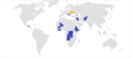
 Країни, які завершили процес ратифікації Угоди.png 5,000 × 4,205; 1.53 MB
-
 Миротворчі місії України.png 2,000 × 883; 172 KB
-
 Області УРСР 1932–1991.gif 1,000 × 700; 862 KB
-
 Україна 17-18.jpg 4,736 × 3,453; 4.31 MB


_eng.png)
_ukr.png)


-en.png)


.jpg)


.png)
.png)


.png)


