| Location
|
Upload
|
Photo
|
Object
|
Cat.
|
Coordinates
|
KGS-Nr
|
| Rehetobel
|

|
yes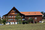
|


|
Bäuerliches Fabrikantenhaus
|
B
|
47°25′28″N 9°29′18″E / 47.42433°N 9.48822°E / 47.42433; 9.48822
|
474
|
| Rehetobel
|
|
yes
|
|
Bäuerliches Fabrikantenhaus
|
B
|
47°25′17″N 9°28′41″E / 47.42152°N 9.47807°E / 47.42152; 9.47807
|
14876
|
| Rehetobel
|
|
yes
|
|
Bäuerliches Fabrikantenhaus
|
B
|
47°25′14″N 9°28′05″E / 47.42067°N 9.468°E / 47.42067; 9.468
|
473
|
| Rehetobel
|
|

|
|
Bauernhaus
|
B
|
47°26′00″N 9°29′14″E / 47.43327°N 9.4873°E / 47.43327; 9.4873
|
11391
|
| Rehetobel
|
|
|
|
Bauernhaus
|
B
|
47°25′27″N 9°29′47″E / 47.42406°N 9.49646°E / 47.42406; 9.49646
|
11393
|
| Rehetobel
|
|
|
|
Bauernhaus
|
B
|
47°26′00″N 9°28′41″E / 47.43333°N 9.47801°E / 47.43333; 9.47801
|
11395
|
| Rehetobel
|
|
|
|
Bauernhaus
|
B
|
47°25′25″N 9°30′12″E / 47.42349°N 9.50325°E / 47.42349; 9.50325
|
11394
|
| Rehetobel
|
|
yes
|
|
Bauernhaus
|
B
|
47°25′19″N 9°28′39″E / 47.42199°N 9.47757°E / 47.42199; 9.47757
|
471
|
| Rehetobel
|
|
yes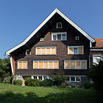
|
|
Bauernhaus
|
B
|
47°25′17″N 9°28′42″E / 47.42139°N 9.47845°E / 47.42139; 9.47845
|
14877
|
| Rehetobel
|
|
yes
|
|
Ehemaliges Weberhaus
|
B
|
47°25′17″N 9°28′40″E / 47.42144°N 9.47781°E / 47.42144; 9.47781
|
14878
|
| Rehetobel
|
|
|
|
Ehemaliges Weberhöckli
|
B
|
47°25′28″N 9°29′20″E / 47.42436°N 9.48885°E / 47.42436; 9.48885
|
14879
|
| Rehetobel
|
|
|
|
Gedeckte Holzbrücke
|
B
|
47°25′51″N 9°27′08″E / 47.4309°N 9.45225°E / 47.4309; 9.45225
|
470
|
| Rehetobel
|
|
|
|
Gedeckte Holzbrücke (1739)
|
B
|
47°25′15″N 9°27′30″E / 47.4208°N 9.45845°E / 47.4208; 9.45845
|
475
|
| Rehetobel
|
|
yes
|
|
Reformierte Kirche
|
B
|
47°25′34″N 9°28′57″E / 47.42618°N 9.4825°E / 47.42618; 9.4825
|
476
|
| Rehetobel
|
|
yes
|
|
Wirtshaus zum Bären
|
B
|
47°25′53″N 9°28′01″E / 47.43142°N 9.46705°E / 47.43142; 9.46705
|
477
|
| Rehetobel
|
|
yes
|
|
Wohnhaus
|
B
|
47°25′54″N 9°28′03″E / 47.43164°N 9.46759°E / 47.43164; 9.46759
|
14880
|
| Reute
|
|
|
|
Bauernhaus
|
B
|
47°25′25″N 9°33′58″E / 47.42354°N 9.56604°E / 47.42354; 9.56604
|
480
|
| Reute
|
|
|
|
Bauernhaus
|
B
|
47°25′14″N 9°33′33″E / 47.42052°N 9.55919°E / 47.42052; 9.55919
|
11407
|
| Reute
|
|
|
|
Bauernhaus
|
B
|
47°25′32″N 9°34′20″E / 47.42556°N 9.57209°E / 47.42556; 9.57209
|
11409
|
| Reute
|
|
|
|
Bauernhaus
|
B
|
47°25′32″N 9°34′18″E / 47.42552°N 9.57174°E / 47.42552; 9.57174
|
14884
|
| Reute
|
|
|
|
Bauernhaus
|
B
|
47°25′26″N 9°33′57″E / 47.42394°N 9.56581°E / 47.42394; 9.56581
|
14882
|
| Reute
|
|
|
|
Bauernhaus
|
B
|
47°25′27″N 9°33′58″E / 47.42428°N 9.56602°E / 47.42428; 9.56602
|
14883
|
| Reute
|
|
|
|
Bauernhaus
|
B
|
47°25′22″N 9°33′23″E / 47.4228°N 9.55644°E / 47.4228; 9.55644
|
14881
|
| Reute
|
|
|
|
Bauernhaus
|
B
|
47°25′08″N 9°34′30″E / 47.4189°N 9.57494°E / 47.4189; 9.57494
|
11401
|
| Reute
|
|
|
|
Bauernhaus
|
B
|
47°25′26″N 9°33′25″E / 47.42394°N 9.55701°E / 47.42394; 9.55701
|
11406
|
| Reute
|
|
|
|
Bauernhaus
|
B
|
47°25′12″N 9°33′50″E / 47.42°N 9.56377°E / 47.42; 9.56377
|
11403
|
| Reute
|
|
|
|
Bauernhaus
|
B
|
47°25′41″N 9°33′20″E / 47.42808°N 9.55562°E / 47.42808; 9.55562
|
11404
|
| Reute
|
|
|
|
Bauernhaus
|
B
|
47°25′04″N 9°33′52″E / 47.41769°N 9.56444°E / 47.41769; 9.56444
|
11405
|
| Reute
|
|
|
|
Ehemaliges Restaurant Rose
|
B
|
47°24′57″N 9°34′42″E / 47.41584°N 9.57847°E / 47.41584; 9.57847
|
11410
|
| Reute
|
|
|
|
Reformierte Kirche (1688)
|
B
|
47°25′12″N 9°34′31″E / 47.4201°N 9.57522°E / 47.4201; 9.57522
|
482
|
| Schönengrund
|
|
|
|
Bauernhaus
|
B
|
|
14885
|
| Schönengrund
|
|
|
|
Bauernhaus
|
B
|
47°19′32″N 9°14′07″E / 47.32567°N 9.23534°E / 47.32567; 9.23534
|
11414
|
| Schönengrund
|
|
|
|
Ehemaliges Bad Bruggli
|
B
|
47°18′54″N 9°13′39″E / 47.3151°N 9.22753°E / 47.3151; 9.22753
|
484
|
| Schönengrund
|
|
yes
|
|
Reformierte Kirche (1720)
|
B
|
47°19′33″N 9°13′35″E / 47.32577°N 9.22626°E / 47.32577; 9.22626
|
483
|
| Schwellbrunn
|
|
|
|
Bauernhaus
|
B
|
47°20′46″N 9°15′53″E / 47.34606°N 9.2648°E / 47.34606; 9.2648
|
488
|
| Schwellbrunn
|
|
|
|
Bauernhaus
|
B
|
47°20′45″N 9°15′36″E / 47.34582°N 9.2599°E / 47.34582; 9.2599
|
14889
|
| Schwellbrunn
|
|
|
|
Bauernhaus
|
B
|
47°20′45″N 9°15′52″E / 47.34582°N 9.26431°E / 47.34582; 9.26431
|
14886
|
| Schwellbrunn
|
|
|
|
Bauernhaus
|
B
|
47°20′45″N 9°15′52″E / 47.34592°N 9.26445°E / 47.34592; 9.26445
|
14887
|
| Schwellbrunn
|
|
|
|
Bauernhaus
|
B
|
47°22′11″N 9°14′12″E / 47.36961°N 9.23662°E / 47.36961; 9.23662
|
14888
|
| Schwellbrunn
|
|
|
|
Bauernhaus
|
B
|
47°21′35″N 9°13′18″E / 47.35973°N 9.22165°E / 47.35973; 9.22165
|
11422
|
| Schwellbrunn
|
|
|
|
Bauernhaus (1737)
|
B
|
47°21′54″N 9°13′50″E / 47.36502°N 9.23046°E / 47.36502; 9.23046
|
11421
|
| Schwellbrunn
|
|
|
|
Gasthaus
|
B
|
47°22′05″N 9°13′19″E / 47.36817°N 9.22201°E / 47.36817; 9.22201
|
11423
|
| Schwellbrunn
|
|
yes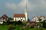
|
|
Reformierte Kirche (1648, 1877)
|
B
|
47°21′09″N 9°14′58″E / 47.3524°N 9.24952°E / 47.3524; 9.24952
|
489
|
| Schwellbrunn
|
|
|
|
Wohnhaus
|
B
|
47°21′55″N 9°13′04″E / 47.36522°N 9.21775°E / 47.36522; 9.21775
|
11424
|
| Speicher
|
|
yes
|
|
Ehemaliges Haus Zuberbühler
|
A
|
47°24′42″N 9°26′27″E / 47.411571°N 9.44092°E / 47.411571; 9.44092
|
491
|
| Speicher
|
|
|
|
Bauernhaus
|
B
|
47°24′32″N 9°27′14″E / 47.40888°N 9.45387°E / 47.40888; 9.45387
|
11444
|
| Speicher
|
|
|
|
Bauernhaus
|
B
|
47°25′39″N 9°26′14″E / 47.42751°N 9.43719°E / 47.42751; 9.43719
|
11429
|
| Speicher
|
|
|
|
Bauernhaus
|
B
|
47°24′50″N 9°26′10″E / 47.41376°N 9.43607°E / 47.41376; 9.43607
|
11430
|
| Speicher
|
|
|
|
Bauernhaus
|
B
|
47°25′03″N 9°27′36″E / 47.41743°N 9.45987°E / 47.41743; 9.45987
|
14890
|
| Speicher
|
|
|
|
Bauernhaus
|
B
|
47°23′38″N 9°26′51″E / 47.39381°N 9.44749°E / 47.39381; 9.44749
|
11438
|
| Speicher
|
|
|
|
Bauernhaus
|
B
|
47°23′45″N 9°26′11″E / 47.39588°N 9.43649°E / 47.39588; 9.43649
|
11441
|
| Speicher
|
|
|
|
Bauernhaus
|
B
|
47°24′49″N 9°27′08″E / 47.41354°N 9.45228°E / 47.41354; 9.45228
|
11431
|
| Speicher
|
|
|
|
Ehemaliges Kurhaus
|
B
|
47°24′43″N 9°25′59″E / 47.41192°N 9.433°E / 47.41192; 9.433
|
14891
|
| Speicher
|
|
yes
|
|
Reformierte Kirche (1810)
|
B
|
47°24′47″N 9°26′34″E / 47.41311°N 9.44278°E / 47.41311; 9.44278
|
11425
|
| Speicher
|
|
|
|
Schützenhaus
|
B
|
47°24′55″N 9°26′15″E / 47.41515°N 9.43744°E / 47.41515; 9.43744
|
14892
|
| Speicher
|
|
|
|
Tätschdachhaus
|
B
|
47°24′52″N 9°26′13″E / 47.41442°N 9.43683°E / 47.41442; 9.43683
|
14893
|
| Speicher
|
|
|
|
Weberhaus
|
B
|
47°25′53″N 9°26′40″E / 47.43138°N 9.44444°E / 47.43138; 9.44444
|
11442
|
| Speicher
|
|
|
|
Weberhaus
|
B
|
47°25′01″N 9°27′36″E / 47.41705°N 9.45996°E / 47.41705; 9.45996
|
14894
|
| Speicher
|
|
|
|
Weberhaus
|
B
|
47°25′39″N 9°27′01″E / 47.42761°N 9.45027°E / 47.42761; 9.45027
|
11434
|
| Speicher
|
|
|
|
Wohnhaus
|
B
|
47°25′17″N 9°27′03″E / 47.42127°N 9.45094°E / 47.42127; 9.45094
|
11437
|
| Stein
|
|
yes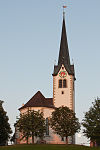
|
|
Reformierte Kirche
|
B
|
47°22′30″N 9°20′38″E / 47.37501°N 9.34385°E / 47.37501; 9.34385
|
11446
|
| Stein
|
|
yes
|
|
Haggenbrücke
|
A
|
47°23′59″N 9°20′22″E / 47.3998°N 9.33937°E / 47.3998; 9.33937
|
8306
|
| Stein
|
|
yes
|
|
Appenzeller Volkskunde-Museum
|
A
|
47°22′22″N 9°20′41″E / 47.3729°N 9.34461°E / 47.3729; 9.34461
|
8572
|
| Stein
|
|
yesGmündertobelbrücke
|
|
Gmündertobelbrücke
|
A
|
47°23′16″N 9°20′53″E / 47.387777777°N 9.348055555°E / 47.387777777; 9.348055555
|
9074
|
| Stein
|
|
|
|
Bauernhaus
|
B
|
47°22′06″N 9°20′59″E / 47.36844°N 9.34971°E / 47.36844; 9.34971
|
11452
|
| Stein
|
|
|
|
Bauernhaus
|
B
|
47°22′29″N 9°20′30″E / 47.37464°N 9.3418°E / 47.37464; 9.3418
|
11451
|
| Stein
|
|
|
|
Bauernhaus
|
B
|
47°23′31″N 9°20′20″E / 47.39181°N 9.33888°E / 47.39181; 9.33888
|
11455
|
| Stein
|
|
|
|
Bauernhaus Burg
|
B
|
47°21′47″N 9°20′16″E / 47.36298°N 9.33771°E / 47.36298; 9.33771
|
500
|
| Stein
|
|
|
|
Gedeckte Sitterbrücke
|
B
|
47°23′58″N 9°20′23″E / 47.39947°N 9.33976°E / 47.39947; 9.33976
|
10497
|
| Stein
|
|
|
|
Gedeckte Urnäschbrücke
|
B
|
|
14895
|
| Stein
|
|
|
|
Heidenhaus Rain
|
B
|
47°22′00″N 9°20′52″E / 47.36674°N 9.34781°E / 47.36674; 9.34781
|
11454
|
| Stein
|
|
|
|
Wirtshaus
|
B
|
47°21′48″N 9°20′30″E / 47.3633°N 9.34155°E / 47.3633; 9.34155
|
11457
|
| Stein
|
|
yes
|
|
Kubelbrücke
|
A
|
47°24′00″N 9°19′35″E / 47.3999°N 9.3265°E / 47.3999; 9.3265
|
10513
|
| Bezirk Hinterland
|
|
yes
|
|
Schwellbrunn
|
ISOS
|
47°21′08″N 9°14′56″E / 47.3523°N 9.249°E / 47.3523; 9.249
|
|
| Teufen
|
|
yes
|
|
Reformierte Kirche Teufen
|
B
|
47°23′24″N 9°23′15″E / 47.38999°N 9.38747°E / 47.38999; 9.38747
|
518
|
| Teufen
|
|
yesGmündertobelbrücke
|
|
Gmündertobelbrücke
|
A
|
47°23′16″N 9°20′53″E / 47.387777777°N 9.348055555°E / 47.387777777; 9.348055555
|
9074
|
| Teufen
|
|
|
|
Grubenmann-Museum
|
B
|
47°23′13″N 9°23′39″E / 47.38702°N 9.39422°E / 47.38702; 9.39422
|
14904
|
| Teufen
|
|
|
|
Bäuerliches Fabrikantenhaus
|
B
|
47°23′59″N 9°21′56″E / 47.39971°N 9.36567°E / 47.39971; 9.36567
|
504
|
| Teufen
|
|
|
|
Bauernhaus
|
B
|
47°23′52″N 9°22′09″E / 47.39774°N 9.36917°E / 47.39774; 9.36917
|
11472
|
| Teufen
|
|
|
|
Bauernhaus
|
B
|
47°23′41″N 9°23′47″E / 47.3948°N 9.39652°E / 47.3948; 9.39652
|
11465
|
| Teufen
|
|
|
|
Bauernhaus
|
B
|
47°24′02″N 9°24′41″E / 47.40046°N 9.41127°E / 47.40046; 9.41127
|
11476
|
| Teufen
|
|
|
|
Bauernhaus
|
B
|
47°23′52″N 9°24′19″E / 47.39777°N 9.40524°E / 47.39777; 9.40524
|
505
|
| Teufen
|
|
|
|
Bauernhaus
|
B
|
47°23′59″N 9°21′55″E / 47.39974°N 9.3653°E / 47.39974; 9.3653
|
14897
|
| Teufen
|
|
|
|
Bauernhaus
|
B
|
47°23′48″N 9°22′24″E / 47.39676°N 9.37325°E / 47.39676; 9.37325
|
14900
|
| Teufen
|
|
|
|
Bauernhaus
|
B
|
47°23′42″N 9°23′38″E / 47.39491°N 9.39377°E / 47.39491; 9.39377
|
11482
|
| Teufen
|
|
|
|
Bauernhaus
|
B
|
47°23′47″N 9°22′27″E / 47.39652°N 9.3741°E / 47.39652; 9.3741
|
14901
|
| Teufen
|
|
|
|
Bauernhaus
|
B
|
47°23′56″N 9°21′55″E / 47.39879°N 9.36514°E / 47.39879; 9.36514
|
14898
|
| Teufen
|
|
|
|
Bauernhaus
|
B
|
47°23′55″N 9°24′20″E / 47.39852°N 9.40551°E / 47.39852; 9.40551
|
14899
|
| Teufen
|
|
|
|
Bauernhaus
|
B
|
47°23′40″N 9°21′01″E / 47.39447°N 9.35033°E / 47.39447; 9.35033
|
11460
|
| Teufen
|
|
|
|
Bauernhaus
|
B
|
47°23′24″N 9°22′37″E / 47.38998°N 9.3769°E / 47.38998; 9.3769
|
11464
|
| Teufen
|
|
|
|
Bauernhaus
|
B
|
47°23′57″N 9°21′54″E / 47.3993°N 9.36506°E / 47.3993; 9.36506
|
14896
|
| Teufen
|
|
|
|
Bauernhaus
|
B
|
47°24′03″N 9°21′44″E / 47.40077°N 9.36212°E / 47.40077; 9.36212
|
11470
|
| Teufen
|
|
|
|
Bauernhaus
|
B
|
47°23′45″N 9°24′09″E / 47.39597°N 9.40261°E / 47.39597; 9.40261
|
11478
|
| Teufen
|
|
|
|
Ehemalige Mühle
|
B
|
47°22′41″N 9°23′54″E / 47.37805°N 9.39827°E / 47.37805; 9.39827
|
516
|
| Teufen
|
|
|
|
Ehemalige Mühle
|
B
|
47°23′23″N 9°24′12″E / 47.3897°N 9.40321°E / 47.3897; 9.40321
|
11462
|
| Teufen
|
|
|
|
Ehemalige Mühle «Pfauen«
|
B
|
47°23′49″N 9°25′18″E / 47.397°N 9.42163°E / 47.397; 9.42163
|
11480
|
| Teufen
|
|
|
|
Ehemaliger Pulverturm
|
B
|
47°22′50″N 9°23′25″E / 47.38042°N 9.3902°E / 47.38042; 9.3902
|
11471
|
| Teufen
|
|
|
|
Ehemaliges Weberhaus
|
B
|
47°23′46″N 9°24′10″E / 47.39609°N 9.4029°E / 47.39609; 9.4029
|
14902
|
| Teufen
|
|
|
|
Gedeckte Brücke «Rotenbrücke« (1862)
|
B
|
47°22′40″N 9°23′59″E / 47.37781°N 9.39984°E / 47.37781; 9.39984
|
14903
|
| Teufen
|
|
|
|
Gedeckte Sitterbrücke (1787)
|
B
|
|
522
|
| Teufen
|
|
|
|
Goldibach-Brücke (1805)
|
B
|
47°22′57″N 9°23′41″E / 47.38252°N 9.39466°E / 47.38252; 9.39466
|
513
|
| Teufen
|
|
|
|
Heidenhaus
|
B
|
47°23′55″N 9°23′27″E / 47.39851°N 9.39095°E / 47.39851; 9.39095
|
11463
|
| Teufen
|
|
|
|
Tätschdachhaus (1539)
|
B
|
47°23′31″N 9°23′52″E / 47.39184°N 9.39784°E / 47.39184; 9.39784
|
520
|
| Teufen
|
|
|
|
Wohnhaus
|
B
|
47°23′44″N 9°24′08″E / 47.39564°N 9.40226°E / 47.39564; 9.40226
|
14905
|
| Teufen
|
|
|
|
Wohnhaus
|
B
|
47°23′54″N 9°20′54″E / 47.39843°N 9.34842°E / 47.39843; 9.34842
|
11461
|
| Teufen
|
|
|
|
Wolfsstein (1695/1882)
|
B
|
47°24′11″N 9°25′37″E / 47.40313°N 9.42705°E / 47.40313; 9.42705
|
11474
|
| Teufen
|
|
|
|
Zythus
|
B
|
47°23′51″N 9°24′20″E / 47.39741°N 9.40567°E / 47.39741; 9.40567
|
14906
|
| Trogen
|
|
yes
|
|
Pfarr- und Gemeindehaus
|
A
|
47°24′28″N 9°27′54″E / 47.40766°N 9.46505°E / 47.40766; 9.46505
|
525
|
| Trogen
|
|
yes
|
|
Cantonal Library of Appenzell Ausserrhoden (PCP category B object)
|
B
|
47°24′30″N 9°27′51″E / 47.40823°N 9.46417°E / 47.40823; 9.46417
|
8923
|
| Trogen
|
|
yes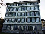
|
|
Ehemaliges Haus Tobler am Berg
|
A
|
47°24′27″N 9°27′51″E / 47.4076°N 9.46415°E / 47.4076; 9.46415
|
537
|
| Trogen
|
|
yes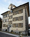
|
|
Ehemaliges Haus Zellweger Nr. 4
|
A
|
47°24′29″N 9°27′56″E / 47.408°N 9.46556°E / 47.408; 9.46556
|
532
|
| Trogen
|
|
yes
|
|
Ehemaliges Mädchenkonvikt
|
A
|
47°24′28″N 9°27′51″E / 47.4078°N 9.46428°E / 47.4078; 9.46428
|
544
|
| Trogen
|
|
yes
|
|
Fünfeckpalast
|
A
|
47°24′30″N 9°27′51″E / 47.4082°N 9.46417°E / 47.4082; 9.46417
|
529
|
| Trogen
|
|
yes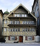
|
|
Gasthaus zur Krone
|
A
|
47°24′28″N 9°27′56″E / 47.4079°N 9.46543°E / 47.4079; 9.46543
|
536
|
| Trogen
|
|
yesRathaus
|
|
Rathaus
|
A
|
47°24′28″N 9°27′55″E / 47.4078°N 9.46525°E / 47.4078; 9.46525
|
527
|
| Trogen
|
|
yes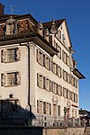
|
|
Sonnenhof
|
A
|
47°24′26″N 9°27′53″E / 47.4072°N 9.46471°E / 47.4072; 9.46471
|
545
|
| Trogen
|
|
yes
|
|
Zellwegerscher Doppelpalast
|
A
|
47°24′30″N 9°27′54″E / 47.4082°N 9.46499°E / 47.4082; 9.46499
|
528
|
| Trogen
|
|
yes
|
|
Reformierte Kirche Trogen
|
A
|
47°24′30″N 9°27′55″E / 47.40821°N 9.46539°E / 47.40821; 9.46539
|
526
|
| Trogen
|
|
|
|
Bauernhaus
|
B
|
47°24′26″N 9°29′06″E / 47.4072°N 9.4849°E / 47.4072; 9.4849
|
11397
|
| Trogen
|
|
|
|
Bauernhaus
|
B
|
47°23′56″N 9°29′10″E / 47.39884°N 9.48621°E / 47.39884; 9.48621
|
14907
|
| Trogen
|
|
|
|
Bauernhaus (1686)
|
B
|
47°23′53″N 9°28′57″E / 47.398°N 9.48255°E / 47.398; 9.48255
|
530
|
| Trogen
|
|
yes
|
|
Blaues Haus
|
B
|
47°24′21″N 9°28′12″E / 47.40588°N 9.46987°E / 47.40588; 9.46987
|
531
|
| Trogen
|
|
|
|
Ehemalige Bleiche (17./18. Jh.)
|
B
|
47°24′30″N 9°28′18″E / 47.40828°N 9.47177°E / 47.40828; 9.47177
|
538
|
| Trogen
|
|
|
|
Heidenhaus
|
B
|
47°24′11″N 9°28′51″E / 47.40298°N 9.4809°E / 47.40298; 9.4809
|
11398
|
| Trogen
|
|
|
|
Heidenhaus
|
B
|
47°23′54″N 9°29′38″E / 47.39832°N 9.4938°E / 47.39832; 9.4938
|
542
|
| Trogen
|
|
|
|
Heidenhaus
|
B
|
47°23′38″N 9°28′34″E / 47.3938°N 9.47611°E / 47.3938; 9.47611
|
11484
|
| Trogen
|
|
|
|
Wohnhaus
|
B
|
47°24′14″N 9°29′30″E / 47.40388°N 9.4918°E / 47.40388; 9.4918
|
14908
|
| Trogen
|
|
|
|
Wohnheim
|
B
|
47°24′27″N 9°27′57″E / 47.40747°N 9.46585°E / 47.40747; 9.46585
|
14909
|
| Trogen
|
|
yes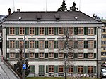
|
|
Kantonsbibliothek Appenzell Ausserrhoden
|
A
|
47°24′28″N 9°27′54″E / 47.40766°N 9.46505°E / 47.40766; 9.46505
|
9323
|
| Urnäsch
|
|
yes
|
|
Appenzeller Brauchtumsmuseum
|
A
|
47°19′02″N 9°16′58″E / 47.317359°N 9.2828°E / 47.317359; 9.2828
|
8507
|
| Urnäsch
|
|
yes
|
|
Wohnhaus mit Mühle
|
A
|
47°19′42″N 9°17′34″E / 47.32839°N 9.292719°E / 47.32839; 9.292719
|
552
|
| Urnäsch
|
|
|
|
Bauernhaus
|
B
|
47°19′51″N 9°16′44″E / 47.33084°N 9.27886°E / 47.33084; 9.27886
|
11492
|
| Urnäsch
|
|
yes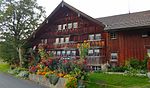
|
|
Bauernhaus
|
B
|
47°18′42″N 9°14′46″E / 47.31159°N 9.2461°E / 47.31159; 9.2461
|
11491
|
| Urnäsch
|
|
|
|
Bauernhaus
|
B
|
47°18′22″N 9°13′48″E / 47.30616°N 9.22992°E / 47.30616; 9.22992
|
11493
|
| Urnäsch
|
|
|
|
Bauernhaus
|
B
|
47°18′32″N 9°15′44″E / 47.30881°N 9.26225°E / 47.30881; 9.26225
|
11495
|
| Urnäsch
|
|
|
|
Bauernhaus
|
B
|
47°19′54″N 9°16′56″E / 47.33155°N 9.28221°E / 47.33155; 9.28221
|
11499
|
| Urnäsch
|
|
|
|
Bauernhaus
|
B
|
47°18′32″N 9°16′15″E / 47.30902°N 9.27074°E / 47.30902; 9.27074
|
549
|
| Urnäsch
|
|
|
|
Bauernhaus
|
B
|
47°18′10″N 9°16′15″E / 47.30269°N 9.27074°E / 47.30269; 9.27074
|
11494
|
| Urnäsch
|
|
|
|
Bauernhaus (1708)
|
B
|
47°18′39″N 9°15′30″E / 47.31087°N 9.25839°E / 47.31087; 9.25839
|
550
|
| Urnäsch
|
|
|
|
Gasthaus Rossfall
|
B
|
47°16′46″N 9°16′47″E / 47.27937°N 9.27981°E / 47.27937; 9.27981
|
14910
|
| Urnäsch
|
|
|
|
Heidenhaus
|
B
|
47°18′07″N 9°16′17″E / 47.302°N 9.27126°E / 47.302; 9.27126
|
11496
|
| Urnäsch
|
|
|
|
Tätschdachhaus
|
B
|
47°17′59″N 9°16′36″E / 47.29963°N 9.27655°E / 47.29963; 9.27655
|
11400
|
| Urnäsch
|
|
|
|
Weberhöckli
|
B
|
47°18′37″N 9°16′40″E / 47.31029°N 9.27784°E / 47.31029; 9.27784
|
11399
|
| Urnäsch
|
|
|
|
Wohnhaus, Nr. 521
|
B
|
47°18′24″N 9°15′47″E / 47.30659°N 9.26311°E / 47.30659; 9.26311
|
11498
|
| Wald
|
|
|
|
Bäuerliches Fabrikantenhaus
|
B
|
47°24′30″N 9°29′40″E / 47.40827°N 9.49448°E / 47.40827; 9.49448
|
11506
|
| Wald
|
|
|
|
Bauernhaus
|
B
|
47°24′52″N 9°28′54″E / 47.41453°N 9.48176°E / 47.41453; 9.48176
|
11504
|
| Wald
|
|
|
|
Bauernhaus
|
B
|
47°24′43″N 9°30′26″E / 47.41201°N 9.50735°E / 47.41201; 9.50735
|
553
|
| Wald
|
|
|
|
Bauernhaus
|
B
|
47°24′42″N 9°30′27″E / 47.41177°N 9.50744°E / 47.41177; 9.50744
|
14911
|
| Wald
|
|
|
|
Bauernhaus
|
B
|
47°24′57″N 9°28′51″E / 47.41576°N 9.4809°E / 47.41576; 9.4809
|
11505
|
| Wald
|
|
|
|
Bauernhaus
|
B
|
47°24′29″N 9°29′47″E / 47.40816°N 9.49634°E / 47.40816; 9.49634
|
14912
|
| Wald
|
|
|
|
Heidenhaus
|
B
|
47°24′21″N 9°30′22″E / 47.40574°N 9.50598°E / 47.40574; 9.50598
|
11503
|
| Wald
|
|
|
|
Reformierte Kirche (1686)
|
B
|
47°24′55″N 9°29′20″E / 47.41541°N 9.48887°E / 47.41541; 9.48887
|
558
|
| Wald
|
|
yes
|
|
Steinbogenbrücke
|
B
|
47°24′29″N 9°30′14″E / 47.40794°N 9.50378°E / 47.40794; 9.50378
|
14913
|
| Waldstatt
|
|
|
|
Bauernhaus
|
B
|
47°21′10″N 9°16′51″E / 47.35281°N 9.28097°E / 47.35281; 9.28097
|
560
|
| Waldstatt
|
|
|
|
Bauernhaus
|
B
|
47°20′52″N 9°16′46″E / 47.34771°N 9.27953°E / 47.34771; 9.27953
|
14915
|
| Waldstatt
|
|
|
|
Bauernhaus
|
B
|
47°20′51″N 9°16′49″E / 47.34748°N 9.28035°E / 47.34748; 9.28035
|
563
|
| Waldstatt
|
|
|
|
Bauernhaus
|
B
|
47°21′08″N 9°17′30″E / 47.35233°N 9.29171°E / 47.35233; 9.29171
|
14916
|
| Waldstatt
|
|
|
|
Bauernhaus
|
B
|
47°21′02″N 9°17′30″E / 47.35049°N 9.29157°E / 47.35049; 9.29157
|
566
|
| Waldstatt
|
|
|
|
Bauernhaus
|
B
|
47°21′30″N 9°16′58″E / 47.35838°N 9.28264°E / 47.35838; 9.28264
|
14914
|
| Waldstatt
|
|
|
|
Bauernhaus
|
B
|
47°21′32″N 9°17′03″E / 47.35878°N 9.28406°E / 47.35878; 9.28406
|
11508
|
| Waldstatt
|
|
|
|
Bauernhaus
|
B
|
47°21′58″N 9°17′21″E / 47.36603°N 9.28913°E / 47.36603; 9.28913
|
11509
|
| Waldstatt
|
|
yes
|
|
Reformierte Kirche (1720)
|
B
|
47°21′24″N 9°17′00″E / 47.35657°N 9.28347°E / 47.35657; 9.28347
|
565
|
| Walzenhausen
|
|
yes
|
|
Bäuerliches Fabrikantenhaus
|
B
|
47°26′19″N 9°35′41″E / 47.43872°N 9.59486°E / 47.43872; 9.59486
|
11514
|
| Walzenhausen
|
|
|
|
Bauernhaus
|
B
|
47°26′33″N 9°37′45″E / 47.44242°N 9.62925°E / 47.44242; 9.62925
|
14920
|
| Walzenhausen
|
|
yes
|
|
Bauernhaus
|
B
|
47°26′18″N 9°35′28″E / 47.43822°N 9.59119°E / 47.43822; 9.59119
|
14921
|
| Walzenhausen
|
|
|
|
Bauernhaus
|
B
|
47°26′58″N 9°36′36″E / 47.44945°N 9.61°E / 47.44945; 9.61
|
14917
|
| Walzenhausen
|
|
|
|
Bauernhaus
|
B
|
47°26′32″N 9°37′43″E / 47.44221°N 9.6287°E / 47.44221; 9.6287
|
14918
|
| Walzenhausen
|
|
yes
|
|
Bauernhaus
|
B
|
47°26′37″N 9°34′44″E / 47.44361°N 9.57891°E / 47.44361; 9.57891
|
11513
|
| Walzenhausen
|
|
yes
|
|
Bauernhaus
|
B
|
47°26′28″N 9°34′46″E / 47.44124°N 9.57932°E / 47.44124; 9.57932
|
11517
|
| Walzenhausen
|
|
yes
|
|
Bauernhaus
|
B
|
47°26′50″N 9°35′41″E / 47.44725°N 9.59478°E / 47.44725; 9.59478
|
568
|
| Walzenhausen
|
|
yes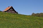
|
|
Bauernhaus
|
B
|
47°26′21″N 9°35′30″E / 47.43908°N 9.59169°E / 47.43908; 9.59169
|
11523
|
| Walzenhausen
|
|
|
|
Bauernhaus
|
B
|
47°26′33″N 9°37′47″E / 47.44246°N 9.62982°E / 47.44246; 9.62982
|
14919
|
| Walzenhausen
|
|
|
|
Bauernhaus mit Torkel
|
B
|
47°26′34″N 9°37′29″E / 47.44282°N 9.62461°E / 47.44282; 9.62461
|
11519
|
| Walzenhausen
|
|
|
|
Doppelbauernhaus
|
B
|
47°26′33″N 9°37′49″E / 47.44241°N 9.63019°E / 47.44241; 9.63019
|
570
|
| Walzenhausen
|
|
yes
|
|
Doppelbauernhaus
|
B
|
47°26′36″N 9°35′29″E / 47.44333°N 9.5913°E / 47.44333; 9.5913
|
11520
|
| Walzenhausen
|
|
|
|
Doppelwohnhaus
|
B
|
47°26′32″N 9°36′17″E / 47.44234°N 9.60477°E / 47.44234; 9.60477
|
11516
|
| Walzenhausen
|
|
|
|
Ehemalige Mühle
|
B
|
47°27′10″N 9°35′47″E / 47.45267°N 9.59645°E / 47.45267; 9.59645
|
11521
|
| Walzenhausen
|
|
yes
|
|
Ehemalige Mühle
|
B
|
47°26′51″N 9°35′44″E / 47.44745°N 9.59548°E / 47.44745; 9.59548
|
14922
|
| Walzenhausen
|
|
yes
|
|
Ehemalige Zwirnerei
|
B
|
47°26′31″N 9°35′10″E / 47.44203°N 9.58618°E / 47.44203; 9.58618
|
14923
|
| Walzenhausen
|
|
|
|
Ehemaliger Rebbauernhof
|
B
|
47°27′15″N 9°35′42″E / 47.45428°N 9.5951°E / 47.45428; 9.5951
|
11511
|
| Walzenhausen
|
|
|
|
Ferggerhaus
|
B
|
47°27′11″N 9°35′44″E / 47.45318°N 9.59543°E / 47.45318; 9.59543
|
11510
|
| Walzenhausen
|
|
yes
|
|
Heidenhaus
|
B
|
47°26′49″N 9°35′20″E / 47.44702°N 9.58888°E / 47.44702; 9.58888
|
11522
|
| Walzenhausen
|
|
yes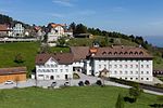
|
|
Kloster-Gebäude
|
B
|
47°26′35″N 9°36′44″E / 47.44318°N 9.61226°E / 47.44318; 9.61226
|
14924
|
| Walzenhausen
|
|
yes
|
|
Reformierte Kirche
|
B
|
47°27′03″N 9°36′17″E / 47.45082°N 9.60479°E / 47.45082; 9.60479
|
569
|
| Walzenhausen
|
|
|
|
Wohnhaus
|
B
|
47°27′25″N 9°35′38″E / 47.45705°N 9.59385°E / 47.45705; 9.59385
|
11524
|
| Wolfhalden
|
|
yes
|
|
Alte Mühle Wolfhalden
|
A
|
47°26′41″N 9°32′16″E / 47.4448°N 9.53779°E / 47.4448; 9.53779
|
571
|
| Wolfhalden
|
|
|
|
Museum Wolfhalden
|
B
|
47°27′12″N 9°33′08″E / 47.45338°N 9.55216°E / 47.45338; 9.55216
|
14928
|
| Wolfhalden
|
|
|
|
Bauernhaus
|
B
|
47°27′00″N 9°32′42″E / 47.45007°N 9.54489°E / 47.45007; 9.54489
|
11531
|
| Wolfhalden
|
|
|
|
Bauernhaus
|
B
|
47°27′22″N 9°34′10″E / 47.45599°N 9.56949°E / 47.45599; 9.56949
|
11527
|
| Wolfhalden
|
|
|
|
Bauernhaus
|
B
|
47°27′20″N 9°32′42″E / 47.45551°N 9.54488°E / 47.45551; 9.54488
|
14925
|
| Wolfhalden
|
|
|
|
Bauernhaus
|
B
|
47°27′19″N 9°32′41″E / 47.45526°N 9.54461°E / 47.45526; 9.54461
|
11532
|
| Wolfhalden
|
|
|
|
Bauernhaus
|
B
|
47°27′29″N 9°33′13″E / 47.45799°N 9.55364°E / 47.45799; 9.55364
|
14926
|
| Wolfhalden
|
|
|
|
Bauernhaus
|
B
|
47°27′23″N 9°33′04″E / 47.45625°N 9.55123°E / 47.45625; 9.55123
|
11534
|
| Wolfhalden
|
|
|
|
Doppelbauernhaus
|
B
|
47°26′39″N 9°32′23″E / 47.44407°N 9.53964°E / 47.44407; 9.53964
|
14927
|
| Wolfhalden
|
|
|
|
Ehemalige Bodenmühle
|
B
|
47°27′50″N 9°33′09″E / 47.46393°N 9.55242°E / 47.46393; 9.55242
|
11526
|
| Wolfhalden
|
|
|
|
Reformierte Kirche (1652)
|
B
|
47°27′14″N 9°33′02″E / 47.45401°N 9.55062°E / 47.45401; 9.55062
|
576
|
| Wolfhalden
|
|
|
|
Weberhaus
|
B
|
47°27′40″N 9°33′25″E / 47.461°N 9.55692°E / 47.461; 9.55692
|
11536
|
| Wolfhalden
|
|
|
|
Weberhaus
|
B
|
47°27′40″N 9°33′25″E / 47.46113°N 9.55696°E / 47.46113; 9.55696
|
14929
|


_318.JPG)


_328.JPG)


