File:At Royal Botanic Gardens, Kew 2024 089.jpg

Size of this preview: 800 × 533 pixels. Other resolutions: 320 × 213 pixels | 640 × 427 pixels | 1,024 × 683 pixels | 1,280 × 853 pixels | 2,560 × 1,707 pixels | 6,960 × 4,640 pixels.
Original file (6,960 × 4,640 pixels, file size: 21.53 MB, MIME type: image/jpeg)
Captions
Captions
Add a one-line explanation of what this file represents
Summary
Object
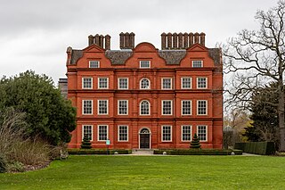
| James Wyatt: Kew Palace
|
|||||||||||||||||||||||||||
|---|---|---|---|---|---|---|---|---|---|---|---|---|---|---|---|---|---|---|---|---|---|---|---|---|---|---|---|
| Architect |
|
.jpg) | |||||||||||||||||||||||||
| Title |
Kew Palace |
||||||||||||||||||||||||||
| Part of |
Kew Gardens |
||||||||||||||||||||||||||
| Object type |
house museum / palace / independent museum |
||||||||||||||||||||||||||
| Date |
1631 |
||||||||||||||||||||||||||
| Collection |
|
||||||||||||||||||||||||||
| Object location |
|
||||||||||||||||||||||||||
| References |
http://www.nationaltrustcollections.org.uk/results?Collections=720726f5fffffe077b00940c880d2852 |
||||||||||||||||||||||||||
| Authority file | |||||||||||||||||||||||||||
| Other versions |
|
||||||||||||||||||||||||||


Photograph
| Date | 16:57:18.18+01:00 |
| Source | Own work |
| Author | Photograph by Mike Peel (www.mikepeel.net). |
| Permission (Reusing this file) |
CC-BY-SA-4.0. Please attribute as per the author line above. |
| Camera location | | View this and other nearby images on: OpenStreetMap |
|---|
| This image is licensed under a Creative Commons Attribution-Share Alike licence, which gives you permission to freely use the image for any purpose, so long as you attribute it as requested here, and you must make any modified versions of it available under an identical license.
If you want to use this image under a different license, for example if you can't give attribution or if you can't share a derivative work under the same licence, then I may ask for a small fee to do so, which will help me cover the cost of my photography equipment. If you use this image outside of the Wikimedia projects, then I'd appreciate it if you could let me know. This isn't compulsory, but it would be nice of you. You can contact me on-wiki or by this form This image was taken using a Canon EOS 90D. |
Licensing
This file is licensed under the Creative Commons Attribution-Share Alike 4.0 International license.
- You are free:
- to share – to copy, distribute and transmit the work
- to remix – to adapt the work
- Under the following conditions:
- attribution – You must give appropriate credit, provide a link to the license, and indicate if changes were made. You may do so in any reasonable manner, but not in any way that suggests the licensor endorses you or your use.
- share alike – If you remix, transform, or build upon the material, you must distribute your contributions under the same or compatible license as the original.
File history
Click on a date/time to view the file as it appeared at that time.
| Date/Time | Thumbnail | Dimensions | User | Comment | |
|---|---|---|---|---|---|
| current | 22:30, 28 February 2024 | | 6,960 × 4,640 (21.53 MB) | Mike Peel (talk | contribs) | Uploaded with LrMediaWiki 1.8.0, LR 13.2 Mac |
You cannot overwrite this file.
File usage on Commons
The following page uses this file: