Maps I created
edit
Some licenses of my pictures
edit
Pictures
edit
 A classical example of waste in the streets of London.
 The waste reaches everywhere. In this case, it is accumulated in the door of a typical house of the Royal Borough of Kensington and Chelsea in London.
 Classical bird's-eye view from an aeroplane.
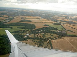 Classical bird's-eye view from an aeroplane.
 Classical bird's-eye view from an aeroplane.
 The racecourse is a classical meeting point for the people of Chester.
 The race has started!
 Six jockeys and their horses taking a curve.
 The Traitor's Gate can be acceded from the River Thames.
 The Spanish Armory exhibition in the Tower of London.
 A train is departing at from a station in the Royal Borough of Kensington and Chelsea in London.
 A misspelling in a notice in the Tower of London. The Spanish word "guide" bears a grave accent on the "i". The grave accent does not exist in Spanish. It should be, instead, an acute accent.
 A monument to Robert Baden-Powell in London. The inscription says: Robert First Baron Baden-Powell of Gilwell Om 1857-1941. Founder of the Boy Scout Movement.
 The plaque of the monument to Robert Baden-Powell in London.
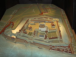 A scale model of the Tower of London. It can be found inside the tower.
 A typical Asian food restaurant in the Royal Borough of Kensington and Chelsea, London.
 A wide variety of objects can be found in the Natural History Museum of London. This, is one of them.
 Hanging skeletons live up the ceiling of one of the side corridors of the main hall of the Natural History Museum of London.
 Kensington Gardens of London in the summer.
 Harrods memorial to Dodi Al-Fayed and Princess Diana.
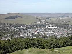 Panoramic view of Buxton from the top of Peak District.
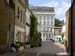 Typical street of the Royal Borough of Kensington and Chelsea in London.
.
.
.
File:Franco Riuades2.jpgFascist general Francisco Franco visiting the flooded shire of Vallès Occidental in 1962.
File:Franco Riuades.jpgFascist general Francisco Franco visiting the flooded shire of Vallès Occidental in 1962.
File:Riuades 1962 5.jpgEffects of the floods in the shire of Vallès Occidental in 1962.
File:Riuades 1962 2.jpgEffects of the floods in the shire of Vallès Occidental in 1962.
File:Ripollet Nevada.jpgEffects of the windfall in the shire of Vallès Occidental in 1962.
.
.
.
.
 The Riu Ripoll seen from La Timba, in Sabadell, Catalonia, Spain.
 The Riu Ripoll seen from La Timba, in Sabadell, Catalonia, Spain.
 The Riu Ripoll seen from La Timba, in Sabadell, Catalonia, Spain.
 In some strech, La Timba is just a half-meter width.
 The locals have planted different species of plants, like this Palm tree. The grass, grows naturally on the clay soil.
 In the mid 1990s, the local police of Sabadell locked the fence so the locals could no longer cultivate their orchards on the cliffs of La Timba.
 In the picture, the fence that sepparates the precipice from the upper side of La Timba, next to the Santiga street, can be seen.
File:Timba Sabadell Localització.PNGMap of La Timba.
In the picture, the fence that sepparates the precipice from the upper side of La Timba, next to the Santiga street, can be seen.
File:Timba Sabadell Localització.PNGMap of La Timba.
.
.
.
.
 Iberian lion of Bujalance, in Andalusia, Spain.
File:AzailaIberianTomb.jpgIberian tomb of Azaila, in Aragón, Spain.
Iberian lion of Bujalance, in Andalusia, Spain.
File:AzailaIberianTomb.jpgIberian tomb of Azaila, in Aragón, Spain.
.
.
.
.
.
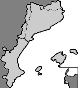 Map of the Catalan Countries.
 Map of the Catalan Countries.
.
.
.
.
.
 Reconstruction of Fort San Miguel.
 Lieutenant Esteban José Martínez Fernández y Martínez de la Sierra, Marina real, circa 1785.
.
.
.
.
.
 Miquelets in a popular celebration in Badalona, Catalonia, Spain.
 Miquelets in a popular celebration in Badalona, Catalonia, Spain.
 Miquelets in a popular celebration in Badalona, Catalonia, Spain.
 Miquelets in a popular celebration in Badalona, Catalonia, Spain.
.
.
.
.
.
 Nootka Sound, marked in a NASA map of Vancouver Island.
File:FriendlyCove.jpgFriendly Cove, Nootka Sound, British Columbia, Canada, where the natives from the region first met the Europeans in the late 18th century, and where the Spanish built Fort San Miguel, the first formal colony in British Columbia.
File:FriendlyCove2.jpgFriendly Cove, Nootka Sound, British Columbia, Canada, where the natives from the region first met the Europeans in the late 18th century, and where the Spanish built Fort San Miguel, the first formal colony in British Columbia.
File:AlberniInlet1.jpgAlberni inlet or canal, British Columbia, Canada. Port Alberni is located at the head of the inlet. Both places are named after Pere d'Alberní i Teixidor, Catalan explorer at the service of the Spanish Crown who was appointed in the region from 1790 to 1792.
File:AlberniInlet2.jpgAlberni inlet or canal, British Columbia, Canada. Port Alberni is located at the head of the inlet. Both places are named after Pere d'Alberní i Teixidor, Catalan explorer at the service of the Spanish Crown who was appointed in the region from 1790 to 1792.
Nootka Sound, marked in a NASA map of Vancouver Island.
File:FriendlyCove.jpgFriendly Cove, Nootka Sound, British Columbia, Canada, where the natives from the region first met the Europeans in the late 18th century, and where the Spanish built Fort San Miguel, the first formal colony in British Columbia.
File:FriendlyCove2.jpgFriendly Cove, Nootka Sound, British Columbia, Canada, where the natives from the region first met the Europeans in the late 18th century, and where the Spanish built Fort San Miguel, the first formal colony in British Columbia.
File:AlberniInlet1.jpgAlberni inlet or canal, British Columbia, Canada. Port Alberni is located at the head of the inlet. Both places are named after Pere d'Alberní i Teixidor, Catalan explorer at the service of the Spanish Crown who was appointed in the region from 1790 to 1792.
File:AlberniInlet2.jpgAlberni inlet or canal, British Columbia, Canada. Port Alberni is located at the head of the inlet. Both places are named after Pere d'Alberní i Teixidor, Catalan explorer at the service of the Spanish Crown who was appointed in the region from 1790 to 1792.


