Category:1750s maps of Pennsylvania
States of the United States: California · Delaware · Florida · Georgia · Kentucky · Louisiana · Maine · Maryland · Massachusetts · Mississippi · New Hampshire · New Jersey · New York · North Carolina · Ohio · Pennsylvania · Rhode Island · South Carolina · Tennessee · Vermont · Virginia
Subcategories
This category has the following 8 subcategories, out of 8 total.
- 1756 maps of Pennsylvania (6 F)
- 1759 maps of Pennsylvania (2 F)
P
Media in category "1750s maps of Pennsylvania"
The following 22 files are in this category, out of 22 total.
-
 (A trader's map of the Ohio country before 1753. LOC gm71002324.jpg 8,845 × 6,217; 7.17 MB
-
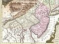 1756 Lotter Map of Eastern Pennsylvania, & New Jersey cropped from Geographicus-1756.jpg 3,600 × 2,700; 4.38 MB
-

-
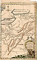 A Map of the Western parts of the Colony of Virginia, 1754.jpg 952 × 1,544; 1.78 MB
-
-
 Cumberland md braddock road.jpg 2,136 × 988; 601 KB
-
 French British Forts 1753 1758.png 328 × 423; 32 KB
-

-

-
 Kitfry-1-.jpg 15,216 × 9,552; 93.04 MB
-
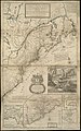
 Map of the Country about the Mississippi, Circa 1755 WDL9587.png 1,729 × 1,024; 2.66 MB
-
-

-

-
 Ohio1755.jpg 933 × 700; 131 KB
-

-
 Plano de Philadelphia. LOC 74691685.jpg 8,769 × 6,288; 7.39 MB
-

-
-
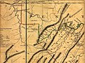
 Washington Pennsylvania Map.jpg 4,743 × 6,136; 15.91 MB
-
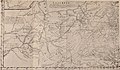
 Washington Pennsylvania Mapb.jpg 4,549 × 5,742; 12 MB
-
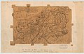
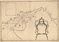
 “A Map of the Land about Red Stone and Fort Pitt,” Used by George Washington WDL9576.png 1,024 × 1,408; 2.14 MB


.jpg)


.jpg)

.jpg)

.jpg)
.jpg)


