Category:1750s maps of Virginia
States of the United States: California · Delaware · Florida · Georgia · Kentucky · Louisiana · Maine · Maryland · Massachusetts · Mississippi · New Hampshire · New Jersey · New York · North Carolina · Ohio · Pennsylvania · Rhode Island · South Carolina · Tennessee · Vermont · Virginia
Subcategories
This category has only the following subcategory.
Media in category "1750s maps of Virginia"
The following 15 files are in this category, out of 15 total.
-

-

-
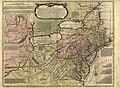
 A new and accurate map of Virginia & Maryland LOC 74693265.jpg 2,769 × 4,264; 2.16 MB
-
 A new and accurate map of Virginia & Maryland LOC 74693266.jpg 2,892 × 4,192; 2.2 MB
-
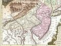 1756 Lotter Map of Eastern Pennsylvania, & New Jersey cropped from Geographicus-1756.jpg 3,600 × 2,700; 4.38 MB
-
-
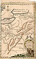 A Map of the Western parts of the Colony of Virginia, 1754.jpg 952 × 1,544; 1.78 MB
-
 A Map of Virginia, .N & S. Carolina, etc. - R. Baldwin - btv1b530895622.jpg 3,352 × 2,768; 1.34 MB
-

-
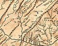 Borden's tract.jpg 360 × 288; 35 KB
-
 Carte de la Virginie et du Maryland (4584051818).jpg 2,000 × 1,524; 3.36 MB
-

-
 Kitfry-1-.jpg 15,216 × 9,552; 93.04 MB
-

-
 Powells creek.jpg 1,859 × 1,251; 1.15 MB


.jpg)
.jpg)

.jpg)
