Category:1795 maps
| ← · 1790 · 1791 · 1792 · 1793 · 1794 · 1795 · 1796 · 1797 · 1798 · 1799 · → |
Deutsch: Karten mit Bezug zum Jahr 1795
English: Maps related to the year 1795
Español: Mapas relativos al año 1795
Français : Cartes concernant l’an 1795
Русский: Карты 1795 года
Subcategories
This category has the following 8 subcategories, out of 8 total.
Media in category "1795 maps"
The following 51 files are in this category, out of 51 total.
-
-
 1795 Berchum.png 1,197 × 823; 2.42 MB
-
 1795 Berchumer Fasselgehölz.png 973 × 809; 1.73 MB
-

-
 Antonio Zatta, L'Arabia (FL33131162 2491055).jpg 12,316 × 9,494; 156.98 MB
-
 Antonio Zatta, Le Dodeci Tribu d'Israele (FL36566264 3914271).jpg 11,480 × 8,295; 132.42 MB
-

-

-
 Carte de Gale et Duberger 1795 (Centre-du-Québec).PNG 859 × 981; 1.13 MB
-
 Carte de Gale et Duberger 1795.PNG 4,935 × 2,240; 11.28 MB
-
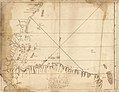 Costa de tierra firme desde el Cabo Gracias a Dios hasta la Ysla Cosumuel LOC 90683545.jpg 7,626 × 5,876; 4.89 MB
-
 Costa de tierra firme desde el Cabo Gracias a Dios hasta la Ysla Cosumuel LOC 90683545.tif 7,626 × 5,876; 128.2 MB
-
 Didier Robert de Vaugondy, Judee ou Terre Sainte (FL6878954 2368994).jpg 2,800 × 1,986; 1.88 MB
-
 Environs of Athens.jpg 3,880 × 2,829; 8.03 MB
-
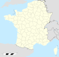 France location map-Departements 1795.svg 2,000 × 1,922; 640 KB
-
 Franz Johann Joseph von Reilly, Karte von Asien (FL27958478 2485802).jpg 20,793 × 16,020; 428.31 MB
-

-
 Giovanni Maria Cassini, L'Impero della Russia in Europa (FL36379276 2606674).jpg 10,485 × 14,105; 212.28 MB
-

-
 Horwood's Plan of London (1792-1799); Horse Shoe Brewery.jpg 1,081 × 810; 186 KB
-
 Innerkrain oder der Adelsberger Kreis 1795.jpg 9,996 × 7,813; 12.77 MB
-

-
 Jeu géographique de la République Française - présenté à la Convention Nationale LOC 79695291.tif 9,452 × 6,531; 176.61 MB
-
 Kaluga vicegerency.jpg 5,335 × 4,930; 4.56 MB
-
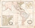 Karte von Amerika - nach D'Anville und Pownall - neu verzeichnet LOC 96686660.jpg 10,016 × 7,894; 11.69 MB
-
 Karte von Amerika - nach D'Anville und Pownall - neu verzeichnet LOC 96686660.tif 10,016 × 7,894; 226.21 MB
-
 Reilly 302.jpg 1,132 × 902; 417 KB
-
 Map from An history of Birmingham.jpg 4,323 × 3,214; 2.91 MB
-
 Map of a portion of Bayou St. John, New Orleans. LOC 2013585051.jpg 5,697 × 4,625; 3.29 MB
-
 Map of a portion of Bayou St. John, New Orleans. LOC 2013585051.tif 5,697 × 4,625; 75.38 MB
-
 Map of Argolis.jpg 5,294 × 3,756; 14.26 MB
-

-

-
-

-
 Map of the World from the best authorities. LOC 98687102.jpg 6,384 × 3,672; 3.95 MB
-
 Map of the World from the best authorities. LOC 98687102.tif 6,384 × 3,672; 67.07 MB
-
 Natur und Kunst Producten Karte von Krain 1795.jpg 11,443 × 8,188; 10.6 MB
-

-

-
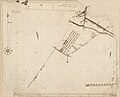
 Plan de coupe du Bastion de Brozillay.png 353 × 498; 528 KB
-
 Plan de la Villa 1795 by Le Brun.png 522 × 480; 398 KB
-
 Plan of the Cities of London and Westminster, 1790s, R. Horwood.png 4,000 × 2,208; 21.43 MB
-
 The island of St. Eustatius corruptly St. Eustatia (4586550799).jpg 2,000 × 1,754; 3.38 MB
-
 The Kingdom of France is represented under the form of a ship. LOC 91680104.jpg 11,550 × 7,001; 16.63 MB
-
 The Kingdom of France is represented under the form of a ship. LOC 91680104.tif 11,550 × 7,001; 231.35 MB
-

-

-
 Two plans in South America - Santa Elena and Melo RMG F0334.tiff 5,401 × 6,945; 107.32 MB
-
 WBR-1795.png 1,642 × 1,389; 1.97 MB
-
 План Николаева 1795.jpg 2,256 × 1,808; 560 KB
.jpg)


.jpg)
.jpg)


.PNG)


.jpg)


.jpg)
.jpg)
.jpg)
;_Horse_Shoe_Brewery_(cropped).jpg)
;_Horse_Shoe_Brewery.jpg)


_of_north_latitude_intended_more_immediately_to_show_the_frontier_boundary_between_the_United_States_and_the_Indian_Tribes_RMG_K1084.jpg)
.jpg)


_on_the_commencement_of_the_seventeenth_century_LOC_2006626086.jpg)


.jpg)

.jpg)
.jpg)

