Category:1840s maps of Georgia
Countries of Europe: Albania · Armenia‡ · Austria · Azerbaijan‡ · Belarus · Belgium · Bosnia and Herzegovina · Bulgaria · Croatia · Cyprus‡ · Czech Republic · Denmark · Finland · France‡ · Georgia‡ · Germany · Greece · Hungary · Republic of Ireland · Italy · Lithuania · Netherlands‡ · Norway · Poland · Portugal‡ · Romania · Russia‡ · Serbia · Slovakia · Slovenia · Spain‡ · Sweden · Switzerland · Turkey‡ · Ukraine · United Kingdom
Limited recognition: Abkhazia‡
‡: partly located in Europe
Limited recognition: Abkhazia‡
‡: partly located in Europe
Media in category "1840s maps of Georgia"
The following 4 files are in this category, out of 4 total.
-
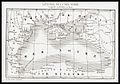 Leonard Chodzko. Littoral de la Mer-Noire. 1840.jpg 1,200 × 840; 288 KB
-
 Map of Tbilisi 1844.jpg 9,364 × 8,432; 48.82 MB
-

-
 Lowry, J.W.; Sharpe, J. Russia at the Caucasus. 1847 (B).jpg 1,396 × 854; 337 KB


.jpg)