Category:1850s maps of Hesse
Federal states of Germany:
Media in category "1850s maps of Hesse"
The following 26 files are in this category, out of 26 total.
-

-
 Darmstadt-Hofmeierei 1850.jpg 2,548 × 1,896; 2.39 MB
-

-

-
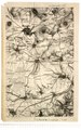
 Karl Julius Gutberlet - Kalvarienberg und Frauenberg.jpg 4,189 × 5,215; 9.4 MB
-
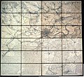
 Karte der Gegend zwischen Gudensberg und Harle.tif 3,415 × 5,451; 53.28 MB
-

-
 Bauernheim 1851.JPG 637 × 469; 93 KB
-
 Bensheim 1832 1850.jpg 1,788 × 1,256; 1.14 MB
-
 Bensheim 1832-1850.jpg 891 × 546; 325 KB
-
 Düstere Landwehr ausgeschnitten aus Kartenblatt Trendelburg von 1857.jpg 2,068 × 1,332; 992 KB
-
 Flurstück An der Landwehr, Kartenblatt Veckerhagen, Landesaufnahme von 1857.jpg 808 × 1,028; 306 KB
-
 Friedenseiche und Läusebusch im Kartenblatt Hofgeismar von 1859 (cropped).jpg 1,000 × 1,000; 384 KB
-
 Fulda.jpg 6,861 × 7,203; 14.63 MB
-
 Immenhausen 1859.jpg 1,692 × 1,550; 1.17 MB
-
 Karte der Umgebung von Frankfurt, um 1850.jpg 5,103 × 4,711; 7.63 MB
-
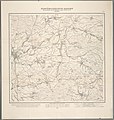
 Kurfürstentum Hessen, Kartenblatt Hofgeismar von 1859.jpg 6,142 × 6,378; 7.38 MB
-
 Kurfürstentum Hessen, Kartenblatt Sababurg von 1857.jpg 6,141 × 6,377; 8.64 MB
-
 Kurfürstentum Hessen, Kartenblatt Trendelburg von 1857.jpg 6,141 × 6,377; 9.97 MB
-
 Kurfürstentum Hessen, Kartenblatt Veckerhagen von 1857.jpg 6,141 × 6,377; 6.16 MB
-
 Kurfürstentum Hessen, Kartenblatt Wilhelmshöhe von 1859.jpg 6,142 × 6,378; 9.07 MB
-
 Kurfürstentum Hessen, Kartenblatt Zierenberg von 1859.jpg 6,141 × 6,377; 7.13 MB
-
 Landwehr zwischen Immenhausen und Holzhausen.png 1,190 × 1,409; 1.52 MB
-
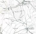 Landwehr zwischen Udenhausen und Carlsdorf.jpg 2,256 × 2,120; 1.36 MB
-
 Reinersen in der Landesaufnahme von 1857 und 1859 des Kurfürstenthums Hessen.png 2,126 × 2,142; 3.35 MB
-
 Saalekreis - Stift Merseburg - Weimar - Jena.jpg 5,110 × 6,696; 15.41 MB
.jpg)


.jpg)


