Category:1860s maps of Paraguay
Countries of the Americas: Argentina · The Bahamas · Belize · Bolivia · Brazil · Canada · Chile · Colombia · Costa Rica · Cuba · Ecuador · Guatemala · Jamaica · Mexico · Panama · Paraguay · Peru · Saint Vincent and the Grenadines · United States of America · Uruguay · Venezuela
Other areas: Puerto Rico
Other areas: Puerto Rico
Media in category "1860s maps of Paraguay"
The following 30 files are in this category, out of 30 total.
-

-
-
-
 Battlefield.png 2,066 × 1,464; 3.32 MB
-
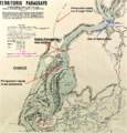 Timbó and Tayí.png 969 × 1,011; 2.42 MB
-
 Humaitá by Chodasiewicz.png 1,920 × 1,080; 1.17 MB
-
 Humaitá and its surroundings.jpg 1,683 × 794; 448 KB
-
 Humaita landward.png 1,926 × 1,592; 3.72 MB
-
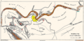
 Humaitá at bay.png 1,206 × 912; 1.29 MB
-
 Humaitá detail.png 567 × 479; 662 KB
-
 Humaitá hemmed in.png 716 × 543; 320 KB
-
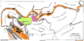
 Humaitá, the endgame.png 1,206 × 912; 1.31 MB
-
 Location of Fort Itapiru.png 3,470 × 4,457; 9.91 MB
-
 Planta de Humaytá.jpg 1,318 × 1,008; 268 KB
-
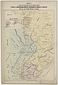
 Strategic Map Humaita 1866.png 2,063 × 1,549; 4.08 MB
-

-
-
 Emergency tramway past Curupayty.png 817 × 758; 1.22 MB
-
 Humaitá (Thompson Plate II).png 1,729 × 857; 1.04 MB
-
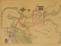
 Humaitá environs and landward defences.png 1,729 × 857; 670 KB
-
 Humaitá landward defences.png 1,729 × 857; 679 KB
-
 Le Tour du monde-04-p099.jpg 2,557 × 2,855; 1,007 KB
-
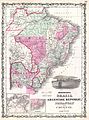
 Map of Brazil, Bolivia, Paraguay, and Uruguay; Map of Chili WDL145.png 1,320 × 1,024; 2.92 MB
-

-

-
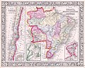
 Republique Argentine, Uruguay, Chili et Paraguay 1862.jpg 3,030 × 3,835; 2.27 MB
-
 Southeastern Paraguay 1867-8.jpg 3,617 × 5,453; 19.53 MB
-
 Strategic Situation 1865.jpg 1,554 × 3,460; 722 KB
-
 Thompson Plate II.1.png 1,729 × 857; 661 KB
-
 Tuyutí to Tuyu-Cué.jpg 2,225 × 1,437; 1.06 MB
.jpg)


.png)


