Category:1860s maps of Puerto Rico
States of the United States: Alabama · Alaska · Arizona · Arkansas · California · Colorado · Connecticut · Delaware · Florida · Georgia · Idaho · Illinois · Indiana · Iowa · Kansas · Kentucky · Louisiana · Maine · Maryland · Massachusetts · Michigan · Minnesota · Mississippi · Missouri · Montana · Nebraska · Nevada · New Hampshire · New Jersey · New Mexico · New York · North Carolina · North Dakota · Ohio · Oklahoma · Oregon · Pennsylvania · Rhode Island · South Carolina · South Dakota · Tennessee · Texas · Utah · Vermont · Virginia · Washington · West Virginia · Wisconsin · Wyoming – Washington, D.C.
Puerto Rico
Puerto Rico
Media in category "1860s maps of Puerto Rico"
The following 9 files are in this category, out of 9 total.
-
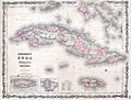 1861 Johnson's Map of Cuba, Jamaica ^ Porto Rico - Geographicus - Cuba-j-61.jpg 3,000 × 2,266; 1.91 MB
-
 1862 Johnson Map of Cuba and Porto Rico - Geographicus - Cuba-johnson-1862.jpg 4,000 × 3,126; 3.72 MB
-

-

-

-

-

-

-


;_Mapa_de_los_contornos_de_San_Juan_de_Puerto_Rico_(inset);_Plano_de_San_Juan_de_Puerto_Rico_(NYPL_Hades-1902807-1808083).jpg)
;_Mapa_de_los_contornos_de_San_Juan_de_Puerto_Rico_(inset);_Plano_de_San_Juan_de_Puerto_Rico_(NYPL_Hades-1902807-1808084).jpg)
;_Mapa_de_los_contornos_de_San_Juan_de_Puerto_Rico_(inset);_Plano_de_San_Juan_de_Puerto_Rico_(NYPL_Hades-1902807-1808085).jpg)
;_Mapa_de_los_contornos_de_San_Juan_de_Puerto_Rico_(inset);_Plano_de_San_Juan_de_Puerto_Rico_(NYPL_Hades-1902807-1808082).jpg)