Category:1861 maps of Ohio
States of the United States: California · Delaware · Florida · Georgia · Illinois · Iowa · Louisiana · Maryland · Massachusetts · Michigan · Nevada · North Carolina · Ohio · South Carolina · Texas · Utah · Virginia · West Virginia – Washington, D.C.
| 1860 1861 → |
Media in category "1861 maps of Ohio"
The following 9 files are in this category, out of 9 total.
-
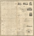
 Map of Ashland County, Ohio LOC 2012591129.jpg 15,247 × 16,456; 34.41 MB
-
 Map of Ashland County, Ohio LOC 2012591129.tif 15,247 × 16,456; 717.84 MB
-
 Map of Lucas Co., Ohio LOC 2012591113.jpg 15,868 × 15,646; 35.86 MB
-
 Map of Lucas Co., Ohio LOC 2012591113.tif 15,868 × 15,646; 710.31 MB
-

-
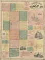
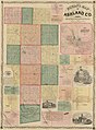 Nunan's map of Ashland Co., Ohio - showing the sections, farms, lots, & villages LOC 2012592384.jpg 12,585 × 17,080; 28.01 MB
-
 Nunan's map of Ashland Co., Ohio - showing the sections, farms, lots, & villages LOC 2012592384.tif 12,585 × 17,080; 614.98 MB
-
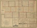
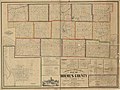 Sectional & topographical map of Holmes County, Ohio LOC 2012591117.jpg 16,093 × 12,119; 27.3 MB
-
 Sectional & topographical map of Holmes County, Ohio LOC 2012591117.tif 16,093 × 12,119; 557.99 MB


.jpg)

