Category:1861 maps of Washington, D.C.
States of the United States: California · Delaware · Florida · Georgia · Illinois · Iowa · Louisiana · Maryland · Massachusetts · Michigan · Nevada · North Carolina · Ohio · South Carolina · Texas · Utah · Virginia · West Virginia – Washington, D.C.
| ← 1860 1861 1863 1864 1865 1867 |
Subcategories
This category has only the following subcategory.
Media in category "1861 maps of Washington, D.C."
The following 5 files are in this category, out of 5 total.
-
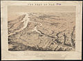 Birds eye view of part of Maryland, Distr of Columbia and part of Virginia (2675386400).jpg 2,000 × 1,467; 2.71 MB
-

-

-

-

.jpg)

.jpg)
