Category:1861 maps of Iowa
States of the United States: California · Delaware · Florida · Georgia · Illinois · Iowa · Louisiana · Maryland · Massachusetts · Michigan · Mississippi · Nevada · North Carolina · Ohio · South Carolina · Texas · Utah · Virginia · West Virginia · Wisconsin – Washington, D.C.
| ← 1860 1861 1862 1865 1868 1869 |
Media in category "1861 maps of Iowa"
The following 2 files are in this category, out of 2 total.
-
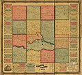 Map of Keokuk County, Iowa LOC 2012587580.jpg 15,417 × 14,090; 26.89 MB
-
 Map of Keokuk County, Iowa LOC 2012587580.tif 15,417 × 14,090; 621.49 MB
