Category:1870s maps of Serbia
Countries of Europe: Armenia‡ · Austria · Azerbaijan‡ · Belgium · Bosnia and Herzegovina · Bulgaria · Croatia · Cyprus‡ · Czech Republic · Denmark · Finland · France‡ · Georgia‡ · Germany · Greece · Hungary · Republic of Ireland · Italy · Latvia · Lithuania · Luxembourg · Netherlands‡ · Norway · Poland · Portugal‡ · Romania · Russia‡ · Serbia · Slovenia · Spain‡ · Sweden · Switzerland · Turkey‡ · Ukraine · United Kingdom
Limited recognition: Abkhazia‡
‡: partly located in Europe
Limited recognition: Abkhazia‡
‡: partly located in Europe
Media in category "1870s maps of Serbia"
The following 9 files are in this category, out of 9 total.
-
 Greater Serbia, Miloš Milojević (1873).jpg 976 × 717; 371 KB
-

-
 1876 - General-Karte von Bosnien, der Hercegovina, von Serbien und Montenegro.jpg 23,376 × 15,604; 94.48 MB
-

-
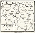 Carte de La Serbie de 1878.jpg 1,640 × 1,513; 276 KB
-
-
 План Београда... - (publié par Stephan Zaritch) - btv1b53021121t.jpg 12,056 × 15,898; 22.1 MB
-

-
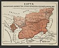
 Карта Балкан по Сан-Стефанскому миру.jpg 1,912 × 1,465; 1.06 MB
.jpg)
_With_numerous_maps_and_notes%27_(11108574054).jpg)


%D0%9D%D0%B5%D1%87%D0%B0%D0%B5%D0%B2.jpg)
_-_btv1b53021121t.jpg)
_With_numerous_maps_and_notes%27_(11109683093).jpg)
