Category:1885 maps of Delaware
States of the United States: California · Connecticut · Delaware · Florida · Georgia · Illinois · Iowa · Kansas · Kentucky · Louisiana · Maine · Maryland · Massachusetts · Michigan · Minnesota · Mississippi · Missouri · Nevada · New Hampshire · New Jersey · New York · North Carolina · Ohio · Oregon · Pennsylvania · Rhode Island · Tennessee · Texas · Vermont · Virginia · Washington · Wisconsin – Washington, D.C.
| 1884 1885 |
Subcategories
This category has the following 2 subcategories, out of 2 total.
Media in category "1885 maps of Delaware"
The following 13 files are in this category, out of 13 total.
-
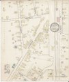
 Clayton, Delaware (2674623320).jpg 2,000 × 1,776; 2.72 MB
-
 Dover, Delaware (2673796829).jpg 2,000 × 1,483; 2.9 MB
-
 Georgetown, Delaware (2673800713).jpg 2,000 × 1,583; 2.42 MB
-
 Harrington, Delaware (2674620036).jpg 2,000 × 1,569; 2.2 MB
-
 Middletown, Delaware (2674619046).jpg 2,000 × 1,584; 2.49 MB
-
 Milford, Delaware (2673797843).jpg 2,000 × 1,583; 2.6 MB
-
 Sanborn Fire Insurance Map from Frederica, Kent County, Delaware. LOC sanborn01210 001.jpg 6,450 × 7,650; 2.77 MB
-
 Sanborn Fire Insurance Map from Frederica, Kent County, Delaware. LOC sanborn01210 001.tif 6,450 × 7,650; 141.17 MB
-
 Sanborn Fire Insurance Map from Harrington, Kent County, Delaware. LOC sanborn01213 001.jpg 6,450 × 7,650; 3.59 MB
-
 Sanborn Fire Insurance Map from Harrington, Kent County, Delaware. LOC sanborn01213 001.tif 6,450 × 7,650; 141.17 MB
-
 Sanborn Fire Insurance Map from Seaford, Sussex County, Delaware. LOC sanborn01223 001.jpg 6,450 × 7,650; 3.31 MB
-
 Sanborn Fire Insurance Map from Seaford, Sussex County, Delaware. LOC sanborn01223 001.tif 6,450 × 7,650; 141.17 MB
-
 Smyrna, Delaware (2673801993).jpg 2,000 × 1,569; 2.75 MB
.jpg)
.jpg)
.jpg)
.jpg)
.jpg)
.jpg)


.jpg)