Category:1885 maps of Vermont
States of the United States: California · Connecticut · Delaware · Florida · Georgia · Illinois · Iowa · Kansas · Kentucky · Louisiana · Maine · Maryland · Massachusetts · Michigan · Minnesota · Mississippi · Missouri · Nevada · New Hampshire · New Jersey · New York · North Carolina · Ohio · Oregon · Pennsylvania · Rhode Island · Tennessee · Texas · Vermont · Virginia · Washington · Wisconsin – Washington, D.C.
| 1880 1884 1885 1886 1887 1889 → |
Subcategories
This category has the following 7 subcategories, out of 7 total.
S
Media in category "1885 maps of Vermont"
The following 4 files are in this category, out of 4 total.
-
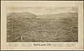 Rutland, Vt. (2675171617).jpg 2,000 × 1,212; 1.92 MB
-
 Rutland, Vt. LOC 75696630.jpg 10,416 × 5,984; 12.6 MB
-
 Rutland, Vt. LOC 75696630.tif 10,416 × 5,984; 178.33 MB
-
 Sanborn Fire Insurance Map from Bristol, Addison County, Vermont. LOC sanborn08911 001.jpg 6,450 × 7,650; 3.17 MB
.jpg)

