Category:1885 maps of Kansas
States of the United States: California · Connecticut · Delaware · Florida · Georgia · Illinois · Iowa · Kansas · Kentucky · Louisiana · Maine · Maryland · Massachusetts · Michigan · Minnesota · Mississippi · Missouri · Nevada · New Hampshire · New Jersey · New York · North Carolina · Ohio · Oregon · Pennsylvania · Rhode Island · Tennessee · Texas · Vermont · Virginia · Washington · Wisconsin – Washington, D.C.
| 1882 1883 1884 1885 1886 1887 1888 1889 → |
Subcategories
This category has the following 12 subcategories, out of 12 total.
S
Media in category "1885 maps of Kansas"
The following 41 files are in this category, out of 41 total.
-
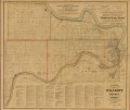
 Edward's map of Wyandott County, Kansas LOC 2012593083.jpg 16,360 × 13,800; 25.19 MB
-
 Edward's map of Wyandott County, Kansas LOC 2012593083.tif 16,360 × 13,800; 645.93 MB
-

-
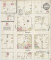
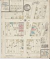
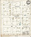
 Sanborn Fire Insurance Map from Junction City, Geary County, Kansas. LOC sanborn02997 001-1.tif 6,450 × 7,650; 141.17 MB
-

-
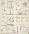
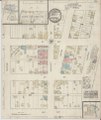
 Sanborn Fire Insurance Map from Junction City, Geary County, Kansas. LOC sanborn02997 001-2.tif 6,450 × 7,650; 141.17 MB
-

-
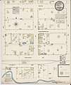
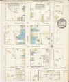
 Sanborn Fire Insurance Map from Junction City, Geary County, Kansas. LOC sanborn02997 001-3.tif 6,450 × 7,650; 141.17 MB
-
 Map of Dickinson County, Kansas LOC 2012593086.jpg 10,795 × 14,028; 21.7 MB
-
 Map of Dickinson County, Kansas LOC 2012593086.tif 10,795 × 14,028; 433.25 MB
-
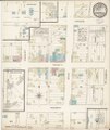
 Sanborn Fire Insurance Map from Alma, Wabaunsee County, Kansas. LOC sanborn02882 001.jpg 6,450 × 7,650; 3.67 MB
-
 Sanborn Fire Insurance Map from Alma, Wabaunsee County, Kansas. LOC sanborn02882 001.tif 6,450 × 7,650; 141.17 MB
-

-
 Sanborn Fire Insurance Map from Baxter Springs, Cherokee County, Kansas. LOC sanborn02897 001.tif 6,450 × 7,650; 141.17 MB
-
 Sanborn Fire Insurance Map from Carbondale, Osage County, Kansas. LOC sanborn02916 001.jpg 6,450 × 7,650; 3.85 MB
-
 Sanborn Fire Insurance Map from Carbondale, Osage County, Kansas. LOC sanborn02916 001.tif 6,450 × 7,650; 141.17 MB
-

-
 Sanborn Fire Insurance Map from Cawker City, Mitchell County, Kansas. LOC sanborn02917 001.tif 6,450 × 7,650; 141.17 MB
-
 Sanborn Fire Insurance Map from Centralia, Nemaba County, Kansas. LOC sanborn02919 001.jpg 6,450 × 7,650; 3.58 MB
-
 Sanborn Fire Insurance Map from Centralia, Nemaba County, Kansas. LOC sanborn02919 001.tif 6,450 × 7,650; 141.17 MB
-
 Sanborn Fire Insurance Map from Cherokee, Crawford County, Kansas. LOC sanborn02923 001.jpg 6,450 × 7,650; 3.59 MB
-
 Sanborn Fire Insurance Map from Cherokee, Crawford County, Kansas. LOC sanborn02923 001.tif 6,450 × 7,650; 141.17 MB
-
-
 Sanborn Fire Insurance Map from Coffeyville, Montgomery County, Kansas. LOC sanborn02930 001.tif 6,450 × 7,650; 141.17 MB
-
 Sanborn Fire Insurance Map from Grenola, Elk County, Kansas. LOC sanborn02975 001.jpg 6,450 × 7,650; 3.57 MB
-
 Sanborn Fire Insurance Map from Grenola, Elk County, Kansas. LOC sanborn02975 001.tif 6,450 × 7,650; 141.17 MB
-
 Sanborn Fire Insurance Map from Howard, Elk County, Kansas. LOC sanborn02989 001.jpg 6,450 × 7,650; 3.48 MB
-
 Sanborn Fire Insurance Map from Howard, Elk County, Kansas. LOC sanborn02989 001.tif 6,450 × 7,650; 141.17 MB
-
 Sanborn Fire Insurance Map from Irving, Marshall County, Kansas. LOC sanborn02995 001.jpg 6,450 × 7,650; 2.97 MB
-
 Sanborn Fire Insurance Map from Irving, Marshall County, Kansas. LOC sanborn02995 001.tif 6,450 × 7,650; 141.17 MB
-
 Sanborn Fire Insurance Map from Neodesha, Wilson County, Kansas. LOC sanborn03037 001.jpg 6,450 × 7,650; 4.14 MB
-

-
 Sanborn Fire Insurance Map from Osage Mission, Neosbe County, Kansas. LOC sanborn03046 001.tif 6,450 × 7,650; 141.17 MB
-

-
 Sanborn Fire Insurance Map from Oskaloosa, Jefferson County, Kansas. LOC sanborn03049 001.tif 6,450 × 7,650; 141.17 MB
-
 Sanborn Fire Insurance Map from Sedan, Chattwuqa County, Kansas. LOC sanborn03078 001.jpg 6,450 × 7,650; 3.44 MB
-
 Sanborn Fire Insurance Map from Sedan, Chattwuqa County, Kansas. LOC sanborn03078 001.tif 6,450 × 7,650; 141.17 MB
-
 Sanborn Fire Insurance Map from Vining, Washington County, Kansas. LOC sanborn03101 001.jpg 6,450 × 7,650; 3.99 MB
-
 Sanborn Fire Insurance Map from Vining, Washington County, Kansas. LOC sanborn03101 001.tif 6,450 × 7,650; 141.17 MB
-
-
 Sanborn Fire Insurance Map from Winchester, Jefferson County, Kansas. LOC sanborn03116 001.tif 6,450 × 7,650; 141.17 MB


