Category:1886 maps of Kansas
States of the United States: California · Connecticut · Georgia · Illinois · Iowa · Kansas · Kentucky · Louisiana · Maine · Maryland · Massachusetts · Michigan · Mississippi · Missouri · Montana · New Hampshire · New Jersey · New Mexico · New York · Ohio · Pennsylvania · Rhode Island · South Carolina · South Dakota · Tennessee · Texas · Utah · Vermont · Virginia · West Virginia · Wisconsin · Wyoming
Puerto Rico
Puerto Rico
| 1882 1883 1884 1885 1886 1887 1888 1889 → |
Subcategories
This category has the following 2 subcategories, out of 2 total.
Media in category "1886 maps of Kansas"
The following 13 files are in this category, out of 13 total.
-
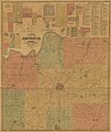 Edward's map of Johnson Co., Kansas LOC 2012593084.jpg 15,268 × 18,147; 35.9 MB
-
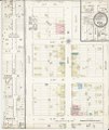
 Sanborn Fire Insurance Map from Burr Oak, Jewell County, Kansas. LOC sanborn02910 001.jpg 6,450 × 7,650; 3.64 MB
-
 Sanborn Fire Insurance Map from Burr Oak, Jewell County, Kansas. LOC sanborn02910 001.tif 6,450 × 7,650; 141.17 MB
-
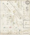
 Sanborn Fire Insurance Map from Coldwater, Comanche County, Kansas. LOC sanborn02932 001.jpg 6,450 × 7,650; 3.24 MB
-
 Sanborn Fire Insurance Map from Coldwater, Comanche County, Kansas. LOC sanborn02932 001.tif 6,450 × 7,650; 141.17 MB
-
 Sanborn Fire Insurance Map from Erie, Neosho County, Kansas. LOC sanborn02954 001.jpg 6,450 × 7,650; 3.67 MB
-
 Sanborn Fire Insurance Map from Erie, Neosho County, Kansas. LOC sanborn02954 001.tif 6,450 × 7,650; 141.17 MB
-

-
 Sanborn Fire Insurance Map from Greenleaf, Washington County, Kansas. LOC sanborn02973 001.tif 6,450 × 7,650; 141.17 MB
-
 Sanborn Fire Insurance Map from Mankato, Jewell County, Kansas. LOC sanborn03026 001.jpg 6,450 × 7,650; 3.33 MB
-
 Sanborn Fire Insurance Map from Mankato, Jewell County, Kansas. LOC sanborn03026 001.tif 6,450 × 7,650; 141.17 MB
-
 Sanborn Fire Insurance Map from Wetmore, Nemaha County, Kansas. LOC sanborn03111 001.jpg 6,450 × 7,650; 3.53 MB
-
 Sanborn Fire Insurance Map from Wetmore, Nemaha County, Kansas. LOC sanborn03111 001.tif 6,450 × 7,650; 141.17 MB


