Category:1886 maps of Montana
States of the United States: California · Connecticut · Georgia · Illinois · Iowa · Kansas · Kentucky · Louisiana · Maryland · Michigan · Mississippi · Missouri · Montana · New Jersey · New Mexico · New York · Ohio · Pennsylvania · South Carolina · South Dakota · Tennessee · Texas · Utah · Virginia · West Virginia · Wisconsin · Wyoming
Puerto Rico
Puerto Rico
| ← 1883 1884 1886 1888 1889 → |
Media in category "1886 maps of Montana"
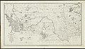
The following 13 files are in this category, out of 13 total.
-
-

-
 Sanborn Fire Insurance Map from Billings, Yellowstone County, Montana. LOC sanborn04939 002-1.tif 6,450 × 7,650; 141.17 MB
-

-
 Sanborn Fire Insurance Map from Billings, Yellowstone County, Montana. LOC sanborn04939 002-2.tif 6,450 × 7,650; 141.17 MB
-

-
 Sanborn Fire Insurance Map from Miles City, Custer County, Montana. LOC sanborn05053 002-1.tif 6,450 × 7,650; 141.17 MB
-

-
 Sanborn Fire Insurance Map from Miles City, Custer County, Montana. LOC sanborn05053 002-2.tif 6,450 × 7,650; 141.17 MB
-

-
 Sanborn Fire Insurance Map from Townsend, Broadwater County, Montana. LOC sanborn05111 002.tif 6,450 × 7,650; 141.17 MB
-

-


