Category:1886 maps of California
States of the United States: California · Connecticut · Georgia · Illinois · Iowa · Kansas · Kentucky · Louisiana · Maine · Maryland · Massachusetts · Michigan · Mississippi · Missouri · Montana · New Hampshire · New Jersey · New Mexico · New York · Ohio · Pennsylvania · Rhode Island · South Carolina · South Dakota · Tennessee · Texas · Utah · Vermont · Virginia · West Virginia · Wisconsin · Wyoming
Puerto Rico
Puerto Rico
| ← 1880 1881 1883 1884 1885 1886 1887 1888 1889 → |
Subcategories
This category has the following 12 subcategories, out of 12 total.
S
Media in category "1886 maps of California"
The following 79 files are in this category, out of 79 total.
-

-

-
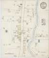
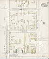
 Sanborn Fire Insurance Map from Arcata, Humboldt County, California. LOC sanborn00391 001-1.tif 6,450 × 7,650; 141.17 MB
-

-
 Sanborn Fire Insurance Map from Arcata, Humboldt County, California. LOC sanborn00391 001-2.tif 6,450 × 7,650; 141.17 MB
-

-
-

-
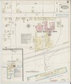
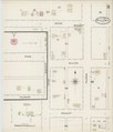
 Sanborn Fire Insurance Map from Benicia, Solano County, California. LOC sanborn00417 001-1.tif 6,450 × 7,650; 141.17 MB
-

-
 Sanborn Fire Insurance Map from Benicia, Solano County, California. LOC sanborn00417 001-2.tif 6,450 × 7,650; 141.17 MB
-

-
 Sanborn Fire Insurance Map from Benicia, Solano County, California. LOC sanborn00417 001-3.tif 6,450 × 7,650; 141.17 MB
-

-
 Sanborn Fire Insurance Map from Benicia, Solano County, California. LOC sanborn00417 001-4.tif 6,450 × 7,650; 141.17 MB
-

-
 Sanborn Fire Insurance Map from Benicia, Solano County, California. LOC sanborn00417 001-5.tif 6,450 × 7,650; 141.17 MB
-

-
 Sanborn Fire Insurance Map from Benicia, Solano County, California. LOC sanborn00417 001-6.tif 6,450 × 7,650; 141.17 MB
-
 Bulletin (1886) (20233773129).jpg 2,052 × 3,274; 1.06 MB
-

-
 Sanborn Fire Insurance Map from Calistoga, Napa County, California. LOC sanborn00442 001-1.tif 6,450 × 7,650; 141.17 MB
-

-
 Sanborn Fire Insurance Map from Calistoga, Napa County, California. LOC sanborn00442 001-2.tif 6,450 × 7,650; 141.17 MB
-

-
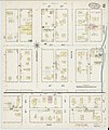
 Sanborn Fire Insurance Map from Colusa, Colusa County, California. LOC sanborn00475 001-1.tif 6,450 × 7,650; 141.17 MB
-
-
 Sanborn Fire Insurance Map from Colusa, Colusa County, California. LOC sanborn00475 001-2.tif 6,450 × 7,650; 141.17 MB
-

-
 Sanborn Fire Insurance Map from Colusa, Colusa County, California. LOC sanborn00475 001-3.tif 6,450 × 7,650; 141.17 MB
-

-
 Sanborn Fire Insurance Map from Colusa, Colusa County, California. LOC sanborn00475 001-4.tif 6,450 × 7,650; 141.17 MB
-
 EB9 San Francisco - map of environs.jpg 857 × 1,185; 310 KB
-
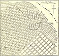 EB9 San Francisco - map of north-eastern part.jpg 1,321 × 1,254; 635 KB
-
 General view of Pasadena looking towards the Sierra Madre Mts.jpg 1,884 × 1,190; 1.16 MB
-

-

-

-
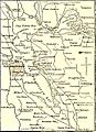
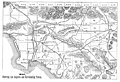 Map showing Los Angeles and Surrounding Towns.jpg 1,620 × 1,101; 789 KB
-
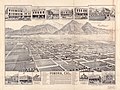 Pomona, Cal. LOC 2004633325.jpg 8,261 × 6,166; 8.4 MB
-
 Pomona, Cal. LOC 2004633325.tif 8,261 × 6,166; 145.73 MB
-

-
 Sanborn Fire Insurance Map from Saint Helena, Napa County, California. LOC sanborn00800 001-1.tif 6,450 × 7,650; 141.17 MB
-

-
 Sanborn Fire Insurance Map from Saint Helena, Napa County, California. LOC sanborn00800 001-2.tif 6,450 × 7,650; 141.17 MB
-

-
 Sanborn Fire Insurance Map from Saint Helena, Napa County, California. LOC sanborn00800 001-3.tif 6,450 × 7,650; 141.17 MB
-

-

-
 Sanborn Fire Insurance Map from Ferndale, Humboldt County, California. LOC sanborn00541 001.tif 6,450 × 7,650; 141.17 MB
-

-
 Sanborn Fire Insurance Map from Gonzales, Monterey County, California. LOC sanborn00571 001.tif 6,450 × 7,650; 141.17 MB
-

-
 Sanborn Fire Insurance Map from Lompoc, Santa Barbara County, California. LOC sanborn00648 001.tif 6,450 × 7,650; 141.17 MB
-

-
 Sanborn Fire Insurance Map from San Pedro, Los Angeles County, California. LOC sanborn00827 001.tif 6,450 × 7,650; 141.17 MB
-

-
-

-

-

-

-

-

-

-

-

-
-

-

-

-

-
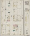
 Sanborn Fire Insurance Map from Willows, Glenn County, California. LOC sanborn00933 001-1.tif 6,450 × 7,650; 141.17 MB
-

-
 Sanborn Fire Insurance Map from Willows, Glenn County, California. LOC sanborn00933 001-2.tif 6,450 × 7,650; 141.17 MB
-
 Sanborn Fire Insurance Map from Willows, Glenn County, California. LOC sanborn00933 001-3.jpg 8,621 × 10,094; 4.94 MB
-
 Sanborn Fire Insurance Map from Willows, Glenn County, California. LOC sanborn00933 001-3.tif 8,621 × 10,094; 248.97 MB
-

-
 Sanborn Fire Insurance Map from Willows, Glenn County, California. LOC sanborn00933 001-4.tif 6,450 × 7,650; 141.17 MB
.jpg)


_(20233773129).jpg)


_on_Southern_Pacific_R.R.,_and_sixteen_miles_east_of_Perris,_on_the_LOC_73694679.jpg)


