Category:1896 U.S. presidential election maps
Subcategories
This category has the following 2 subcategories, out of 2 total.
Media in category "1896 U.S. presidential election maps"
The following 18 files are in this category, out of 18 total.
-
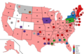
 1896 Electoral Map.png 1,182 × 635; 179 KB
-
 1896 Presidential Election in Massachusetts By Municipality.svg 810 × 502; 236 KB
-
 1896 US Presidential Election in Florida by county.svg 800 × 769; 2.03 MB
-
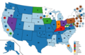
 1896DemocraticPresidentialNomination1stBallot.png 1,513 × 983; 96 KB
-
 1896DemocraticPresidentialNomination2ndBallot.png 1,513 × 983; 91 KB
-
 1896DemocraticPresidentialNomination3rdBallot.png 1,513 × 983; 89 KB
-
 1896DemocraticPresidentialNomination4thBallot.png 1,513 × 983; 88 KB
-
 1896DemocraticPresidentialNomination5thBallot.png 1,513 × 983; 79 KB
-
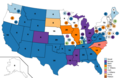
 1896DemocraticVicePresidentialNomination1stBallot.png 1,513 × 983; 94 KB
-
 1896DemocraticVicePresidentialNomination2ndBallot.png 1,513 × 983; 87 KB
-
 1896DemocraticVicePresidentialNomination3rdBallot.png 1,513 × 983; 83 KB
-
 1896DemocraticVicePresidentialNomination4thBallot.png 1,513 × 983; 79 KB
-
 1896DemocraticVicePresidentialNomination5thBallot.png 1,513 × 983; 78 KB
-
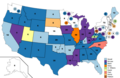
 1896RepublicanPresidentialNomination1stBallot.png 1,513 × 983; 90 KB
-
 ElectoralCollege1896-Large.png 1,182 × 635; 103 KB
-
 ElectoralCollege1896.svg 1,020 × 593; 25 KB
-
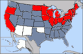 Map of USA presidential elections 1896.PNG 280 × 183; 13 KB
-
 Wjb1896.jpg 962 × 586; 83 KB


