Category:1972 U.S. presidential election maps
Subcategories
This category has the following 5 subcategories, out of 5 total.
1
Media in category "1972 U.S. presidential election maps"
The following 15 files are in this category, out of 15 total.
-
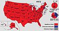
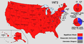 1972 Electoral Map.png 1,182 × 635; 171 KB
-
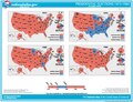
 1972 Presidential Election, Results by Congressional District.png 1,543 × 994; 94 KB
-
 1972 United States Presidential Election in Mahoning County, Ohio.svg 649 × 416; 147 KB
-
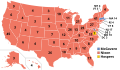
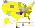 1972DemocraticPresidentialPrimaries.png 640 × 500; 58 KB
-
 1972DemocraticPresidentialPrimaries.svg 959 × 593; 113 KB
-
 1972DemPrimaries.png 796 × 595; 32 KB
-
 1972USPresidentialElectionbyMargin.svg 647 × 432; 3.66 MB
-
 Elect12.pdf 1,591 × 1,218; 1.41 MB
-
 Electoral college 1972.jpg 1,182 × 635; 111 KB
-
 ElectoralCollege1972-Large.png 1,182 × 635; 105 KB
-
 ElectoralCollege1972.svg 1,020 × 593; 28 KB
-
 Hawaii 1972.png 2,435 × 1,351; 14 KB
-
 Map of USA presidential elections 1972.PNG 280 × 183; 13 KB
-
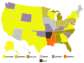
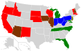
 Republican presidential primary results, 1972.png 959 × 593; 97 KB
-
 United States Democratic presidential primaries, 1972 by state.svg 959 × 593; 37 KB


