Category:18th-century maps of New Mexico
States of the United States: Alabama · Alaska · Arizona · Arkansas · California · Colorado · Connecticut · Delaware · Florida · Georgia · Hawaii · Illinois · Indiana · Kansas · Kentucky · Louisiana · Maine · Maryland · Massachusetts · Michigan · Minnesota · Mississippi · Missouri · Montana · Nevada · New Hampshire · New Jersey · New Mexico · New York · North Carolina · North Dakota · Ohio · Oklahoma · Oregon · Pennsylvania · Rhode Island · South Carolina · Tennessee · Texas · Utah · Vermont · Virginia · Washington · West Virginia · Wisconsin – Washington, D.C.
Puerto Rico
Puerto Rico
Media in category "18th-century maps of New Mexico"
The following 8 files are in this category, out of 8 total.
-
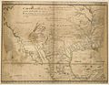 1721 Map of the new part of French Louisiana.jpg 8,104 × 6,291; 14.19 MB
-
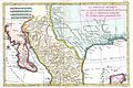 1780 Bonne Map of Texas, Louisiana ^ New Mexico - Geographicus - Texas2-bonne-1780.jpg 3,000 × 2,002; 1.13 MB
-
 Apachean ca.18-century.png 863 × 730; 141 KB
-

-

-
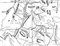 Escalante's Route BHoU-p10.png 3,919 × 2,965; 226 KB
-
 History and government of New Mexico (1921) (14779940671).jpg 2,944 × 1,888; 586 KB
-
 Homann Amplissimae Regionis Mississipi c. 1720 UTA.jpg 6,000 × 5,321; 16.4 MB


_(14779940671).jpg)
