Category:1919 maps of Canada
Countries of North America: Canada · Costa Rica · Mexico · Panama · United States of America‡
‡: partly located in North America
‡: partly located in North America
| ← 1910 1911 1912 1913 1914 1915 1916 1917 1918 1919 → |
English: Maps of Canada from 1919 or related to Canada in 1919
Français : Les cartes du Canada de 1919 ou se rapportant au Canada en 1919
Media in category "1919 maps of Canada"
The following 7 files are in this category, out of 7 total.
-

-

-
 Chataway’s Map of Winnipeg (1919) (2212284333).jpg 7,991 × 9,549; 15.16 MB
-
 Oaxaca map in 1919, from- Plans of Mexican towns 1919-1- (cropped).jpg 944 × 959; 164 KB
-

-
 Report of the Canadian Arctic Expedition 1913-18 (1919) (20600971638).jpg 2,974 × 1,862; 975 KB
-
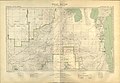 Swan River Sectional Map 221 (1919) (3743151359).jpg 9,856 × 6,788; 9.84 MB
_(20334812659).jpg)
_(2212284333).jpg)
.jpg)
.jpg)
_(20600971638).jpg)
_(3743151359).jpg)
_(14797225553).jpg)