Category:20th-century maps of North Carolina
States of the United States: Alabama · Alaska · Arizona · Arkansas · California · Colorado · Connecticut · Delaware · Florida · Georgia · Hawaii · Idaho · Illinois · Indiana · Iowa · Kansas · Kentucky · Louisiana · Maine · Maryland · Massachusetts · Michigan · Minnesota · Mississippi · Missouri · Montana · Nebraska · Nevada · New Hampshire · New Jersey · New Mexico · New York · North Carolina · North Dakota · Ohio · Oklahoma · Oregon · Pennsylvania · Rhode Island · South Carolina · South Dakota · Tennessee · Texas · Utah · Vermont · Virginia · Washington · West Virginia · Wisconsin · Wyoming – Washington, D.C.
Puerto Rico
Puerto Rico
Subcategories
This category has the following 9 subcategories, out of 9 total.
Media in category "20th-century maps of North Carolina"
The following 20 files are in this category, out of 20 total.
-
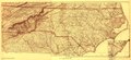
 (North Carolina LOC 99447452.jpg 9,173 × 4,235; 9.71 MB
-
 (North Carolina LOC 99447452.tif 9,173 × 4,235; 111.14 MB
-
 EB1911 North Carolina.jpg 2,472 × 1,834; 2.42 MB
-
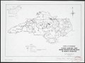
 Flood control and shore protection projects in North Carolina LOC 2005630694.jpg 4,494 × 3,377; 1.6 MB
-
 Flood control and shore protection projects in North Carolina LOC 2005630694.tif 4,494 × 3,377; 43.42 MB
-
 Forest conditions of western North Carolina. LOC 99446147.jpg 8,352 × 5,182; 5.64 MB
-
 Forest conditions of western North Carolina. LOC 99446147.tif 8,352 × 5,182; 123.83 MB
-
 General soil map of North Carolina LOC 2007629229.jpg 10,344 × 10,444; 11.16 MB
-
 General soil map of North Carolina LOC 2007629229.tif 10,344 × 10,444; 309.08 MB
-
 General soil map, Jackson County, North Carolina LOC 93681868.jpg 7,589 × 5,780; 5.24 MB
-
 General soil map, Jackson County, North Carolina LOC 93681868.tif 7,589 × 5,780; 125.5 MB
-
 General soil map, Rockingham County, North Carolina LOC 81693474.jpg 6,057 × 6,688; 4.89 MB
-
 General soil map, Rockingham County, North Carolina LOC 81693474.tif 6,057 × 6,688; 115.9 MB
-
 Terracing of farm lands (1908) (14796790803).jpg 3,056 × 1,308; 883 KB
-
 Transportation map of North Carolina and South Carolina. LOC 77694802.jpg 6,656 × 5,181; 4.1 MB
-
 Transportation map of North Carolina and South Carolina. LOC 77694802.tif 6,656 × 5,181; 98.66 MB
-
 Transportation map of North Carolina and South Carolina. LOC 77694845.jpg 6,679 × 5,169; 4 MB
-
 Transportation map of North Carolina and South Carolina. LOC 77694845.tif 6,679 × 5,169; 98.77 MB
-
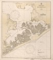
 United States, East Coast, North Carolina - New River Inlet LOC 2012586817.jpg 8,634 × 9,909; 10.66 MB
-
 United States, East Coast, North Carolina - New River Inlet LOC 2012586817.tif 8,634 × 9,909; 244.77 MB


_(14796790803).jpg)
